
Robin Hood (Chorlton on Medlock, Manchester): Difference between revisions
m (Text replacement - "width=34%|service=leaflet|" to "service=leaflet|width=34%|") |
m (Text replacement - "No Copy in NLS" to "No copy in NLS") |
||
| (10 intermediate revisions by the same user not shown) | |||
| Line 1: | Line 1: | ||
__NOTOC__{{ | __NOTOC__{{PlaceNamesItemTop|Lat=53.462865|Lon=-2.231022|AdministrativeDivision=Lancashire|Vicinity=On lost Ducie Grove; N of Denmark Road, S of Devas Street, in Chorlton on Medlock|Type=Public house|Interest=Robin Hood name| | ||
Status=Defunct|Demonym=|Riding=|GreaterLondon=|Year=1867|Aka=|Century=|Cluster1=Manchester|Cluster2=|Cluster3=|Image=robin-hood-chorlton-on-medlock-manchester-google-earth-street-view-1.jpg|Postcards=|ExtraCat1=|ExtraCat2=|ExtraCat3=|ExtraCat4=|ExtraCat5=|ExtraLink1=|ExtraLink2=|ExtraLink3=|ExtraLink4=|ExtraLink5=|ExtraLinkName1=|ExtraLinkName2=|ExtraLinkName3=|ExtraLinkName4=|ExtraLinkName5=|GeopointPrefix=|GeopointSuffix=|VicinitySuffix=|StatusSuffix=|DatePrefix=|DateSuffix=}} | Status=Defunct|Demonym=|Riding=|GreaterLondon=|Year=1867|Aka=|Century=|Cluster1=Manchester|Cluster2=|Cluster3=|Image=robin-hood-chorlton-on-medlock-manchester-google-earth-street-view-1.jpg|Postcards=|ExtraCat1=|ExtraCat2=|ExtraCat3=|ExtraCat4=|ExtraCat5=|ExtraLink1=|ExtraLink2=|ExtraLink3=|ExtraLink4=|ExtraLink5=|ExtraLinkName1=|ExtraLinkName2=|ExtraLinkName3=|ExtraLinkName4=|ExtraLinkName5=|GeopointPrefix=|GeopointSuffix=|VicinitySuffix=|StatusSuffix=|DatePrefix=|DateSuffix=}} | ||
{{#display_map:{{#var:Coords}}~{{#replace:{{PAGENAME}}|'|'}} | {{#display_map:{{#var:Coords}}~{{#replace:{{PAGENAME}}|'|'}}|width=34%|enablefullscreen=yes}}<div class="pnMapLegend">Centrepoint of the lost Ducie Grove which connected Denmark Road, to the south, and Devas Street, then named Ducie Street, to the north.</div> | ||
[[File:{{#var: | [[File:{{#var:Image}}|thumb|right|500px|The Robin Hood was situated on the stretch of Ducie Grove that continued north here from the present Dilworth Street / Google Earth Street View.]]<div class="no-img"> | ||
<p id="byline">By Henrik Thiil Nielsen, 2019-03-04. Revised by {{#realname:{{REVISIONUSER}}}}, {{REVISIONYEAR}}-{{REVISIONMONTH}}-{{REVISIONDAY2}}.</p> | <p id="byline">By Henrik Thiil Nielsen, 2019-03-04. Revised by {{#realname:{{REVISIONUSER}}}}, {{REVISIONYEAR}}-{{REVISIONMONTH}}-{{REVISIONDAY2}}.</p> | ||
The Robin Hood on the now lost Ducie Grove in Chorlton on Medlock, Manchester, figures in licensing registers from 1867 to 1967<ref>[https://pubhistory.co.uk//Lancashire/ManchesterR/RobinHoodDucie.shtml Pub History: Robin Hood, 49 Ducie Grove, Chorlton on Medlock, Manchester, Lancashire.]</ref> and so may have closed for good shortly after celebrating its centennial. It disappeared when the street on which it was situated was turned into a parking lot. Ducie Grove ran almost due north from Denmark Road – at the slight bend where the latter changes it direction a bit to head due west – to Devas Street, which was then named Ducie Street and connected Oxford Road and Lloyd Street (now Lloyd Street North). Ducie Grove is shown, without name, on the 1844 tithe map, but the tithe award does not mention a public house there.<ref>[https://www.thegenealogist.co.uk The Genealogist: Chorlton on Medlock tithe map, Piece 18, Sub-Piece 074, Sub-Image 001] ( | The Robin Hood on the now lost Ducie Grove in Chorlton on Medlock, Manchester, figures in licensing registers from 1867 to 1967<ref>[https://pubhistory.co.uk//Lancashire/ManchesterR/RobinHoodDucie.shtml Pub History: Robin Hood, 49 Ducie Grove, Chorlton on Medlock, Manchester, Lancashire.]</ref> and so may have closed for good shortly after celebrating its centennial. It disappeared when the street on which it was situated was turned into a parking lot. Ducie Grove ran almost due north from Denmark Road – at the slight bend where the latter changes it direction a bit to head due west – to Devas Street, which was then named Ducie Street and connected Oxford Road and Lloyd Street (now Lloyd Street North). Ducie Grove is shown, without name, on the 1844 tithe map, but the tithe award does not mention a public house there.<ref>[https://www.thegenealogist.co.uk The Genealogist: Chorlton on Medlock tithe map, Piece 18, Sub-Piece 074, Sub-Image 001] (£)</ref> | ||
Its place in the sequence of entries in the 1881 census suggests that the Robin Hood was situated somewhere along the stretch of Ducie Grove that would have connected Devas and Dilworth streets had it existed today.<ref>[https://www.thegenealogist.co.uk The Genealogist: 1881 Census. Lancashire, Pirce 03922, Image 00089] ( | Its place in the sequence of entries in the 1881 census suggests that the Robin Hood was situated somewhere along the stretch of Ducie Grove that would have connected Devas and Dilworth streets had it existed today.<ref>[https://www.thegenealogist.co.uk The Genealogist: 1881 Census. Lancashire, Pirce 03922, Image 00089] (£).</ref> This is confirmed by a local blog post on the pub.<ref>[http://pubs-of-manchester.blogspot.com/2011/08/robin-hood-ducie-grove.html Pubs of Manchester, Past & Present: Robin Hood, Ducie Grove.]</ref> | ||
The excellent Pub History website lists information from trade directories and censuses on publicans and other residents for 1876 to 1911.<ref>[https://pubhistory.co.uk//Lancashire/ManchesterR/RobinHoodDucie.shtml Pub History: Robin Hood, 49 Ducie Grove, Chorlton on Medlock, Manchester, Lancashire.]</ref> | The excellent Pub History website lists information from trade directories and censuses on publicans and other residents for 1876 to 1911.<ref>[https://pubhistory.co.uk//Lancashire/ManchesterR/RobinHoodDucie.shtml Pub History: Robin Hood, 49 Ducie Grove, Chorlton on Medlock, Manchester, Lancashire.]</ref> | ||
{{ | {{PlaceNamesItemAllusionsAndRecords}} | ||
== Gazetteers == | == Gazetteers == | ||
* Not included in {{:Dobson, Richard Barrie 1976a}}, pp. 293-311. | * Not included in {{:Dobson, Richard Barrie 1976a}}, pp. 293-311. | ||
== MS sources == | == MS sources == | ||
* [https://www.thegenealogist.co.uk The Genealogist: 1881 Census. Lancashire, Pirce 03922, Image 00089] | * [https://www.thegenealogist.co.uk The Genealogist: 1881 Census. Lancashire, Pirce 03922, Image 00089] | ||
* [https://www.thegenealogist.co.uk The Genealogist: Chorlton on Medlock tithe map, Piece 18, Sub-Piece 074, Sub-Image 001] ( | * [https://www.thegenealogist.co.uk The Genealogist: Chorlton on Medlock tithe map, Piece 18, Sub-Piece 074, Sub-Image 001] (£). | ||
== Printed and web sources == | == Printed and web sources == | ||
| Line 21: | Line 21: | ||
== Maps == | == Maps == | ||
* [https://maps.nls.uk/view/126522869#zoom=4&lat=7662&lon=2443&layers=BT 25" O.S. map ''Lancashire'' CIV.15 (1893; surveyed 1888-89)] | * [https://maps.nls.uk/view/126522869#zoom=4&lat=7662&lon=2443&layers=BT 25" O.S. map ''Lancashire'' CIV.15 (1893; surveyed 1888-89)] | ||
* 25" O.S. map ''Lancashire'' CIV.15 (''c.'' 1908; ''c.'' 1904). No | * 25" O.S. map ''Lancashire'' CIV.15 (''c.'' 1908; ''c.'' 1904). No copy in NLS | ||
* [https://maps.nls.uk/geo/explore/#zoom=17&lat=53.4618&lon=-2.2315&layers=168&b=5 25" O.S. map ''Lancashire'' CIV.15 (1922; rev. 1915-16)] (georeferenced) | * [https://maps.nls.uk/geo/explore/#zoom=17&lat=53.4618&lon=-2.2315&layers=168&b=5 25" O.S. map ''Lancashire'' CIV.15 (1922; rev. 1915-16)] (georeferenced) | ||
* [https://maps.nls.uk/view/126522872#zoom=4&lat=7807&lon=2350&layers=BT 25" O.S. map ''Lancashire'' CIV.15 (1922; rev. 1915-16)] | * [https://maps.nls.uk/view/126522872#zoom=4&lat=7807&lon=2350&layers=BT 25" O.S. map ''Lancashire'' CIV.15 (1922; rev. 1915-16)] | ||
| Line 35: | Line 35: | ||
<!--== Brief mention == | <!--== Brief mention == | ||
* --> | * --> | ||
{{ | {{PlaceNamesItemAlsoSee}} | ||
== Notes == | == Notes == | ||
<references/> | <references/> | ||
| Line 41: | Line 41: | ||
<div id="gallery"> | <div id="gallery"> | ||
{{ | {{ImageGalleryIntroduction}} | ||
<gallery widths="195px"> | <gallery widths="195px"> | ||
File:robin-hood-chorlton-on-medlock-manchester-google-earth-street-view-1.jpg|The Robin Hood was situated on the stretch of Ducie Grove that continued north here from the present Dilworth Street / Google Earth Street View. | File:robin-hood-chorlton-on-medlock-manchester-google-earth-street-view-1.jpg|The Robin Hood was situated on the stretch of Ducie Grove that continued north here from the present Dilworth Street / Google Earth Street View. | ||
| Line 48: | Line 48: | ||
</div> | </div> | ||
{{ | {{PlaceNamesItemNavigation}} | ||
Latest revision as of 01:06, 13 February 2021
| Locality | |
|---|---|
| Coordinate | 53.462865, -2.231022 |
| Adm. div. | Lancashire |
| Vicinity | On lost Ducie Grove; N of Denmark Road, S of Devas Street, in Chorlton on Medlock |
| Type | Public house |
| Interest | Robin Hood name |
| Status | Defunct |
| First Record | 1867 |

By Henrik Thiil Nielsen, 2019-03-04. Revised by Henrik Thiil Nielsen, 2021-02-13.
The Robin Hood on the now lost Ducie Grove in Chorlton on Medlock, Manchester, figures in licensing registers from 1867 to 1967[1] and so may have closed for good shortly after celebrating its centennial. It disappeared when the street on which it was situated was turned into a parking lot. Ducie Grove ran almost due north from Denmark Road – at the slight bend where the latter changes it direction a bit to head due west – to Devas Street, which was then named Ducie Street and connected Oxford Road and Lloyd Street (now Lloyd Street North). Ducie Grove is shown, without name, on the 1844 tithe map, but the tithe award does not mention a public house there.[2]
Its place in the sequence of entries in the 1881 census suggests that the Robin Hood was situated somewhere along the stretch of Ducie Grove that would have connected Devas and Dilworth streets had it existed today.[3] This is confirmed by a local blog post on the pub.[4]
The excellent Pub History website lists information from trade directories and censuses on publicans and other residents for 1876 to 1911.[5]
Gazetteers
- Not included in Dobson, R. B., ed.; Taylor, J., ed. Rymes of Robyn Hood: an Introduction to the English Outlaw (London, 1976), pp. 293-311.
MS sources
- The Genealogist: 1881 Census. Lancashire, Pirce 03922, Image 00089
- The Genealogist: Chorlton on Medlock tithe map, Piece 18, Sub-Piece 074, Sub-Image 001 (£).
Printed and web sources
Maps
- 25" O.S. map Lancashire CIV.15 (1893; surveyed 1888-89)
- 25" O.S. map Lancashire CIV.15 (c. 1908; c. 1904). No copy in NLS
- 25" O.S. map Lancashire CIV.15 (1922; rev. 1915-16) (georeferenced)
- 25" O.S. map Lancashire CIV.15 (1922; rev. 1915-16)
- 25" O.S. map Lancashire CIV.15 (1935; rev. 1933)
- 6" O.S. map Lancashire CIV.SE (1909; rev. 1905) (georeferenced)
- 6" O.S. map Lancashire CIV (1848; surveyed 1845)
- 6" O.S. map Lancashire CIV (1923; rev. 1915-21).
Discussion
Also see
Notes
- ↑ Pub History: Robin Hood, 49 Ducie Grove, Chorlton on Medlock, Manchester, Lancashire.
- ↑ The Genealogist: Chorlton on Medlock tithe map, Piece 18, Sub-Piece 074, Sub-Image 001 (£)
- ↑ The Genealogist: 1881 Census. Lancashire, Pirce 03922, Image 00089 (£).
- ↑ Pubs of Manchester, Past & Present: Robin Hood, Ducie Grove.
- ↑ Pub History: Robin Hood, 49 Ducie Grove, Chorlton on Medlock, Manchester, Lancashire.
Image gallery
Click any image to display it in the lightbox, where you can navigate between images by clicking in the right or left side of the current image.
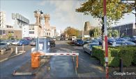
The Robin Hood was situated on the stretch of Ducie Grove that continued north here from the present Dilworth Street / Google Earth Street View.

Ducie Grove led north from about this point on Denmark Road / Google Earth Street View.
