
Robin Hood (Burham): Difference between revisions
m (Text replacement - "PlaceNamesItemQuery" to "PlaceNamesItemAllusionsAndRecords") |
m (Text replacement - "ImgGalleryIntro" to "ImageGalleryIntroduction") |
||
| Line 32: | Line 32: | ||
<div id="gallery"> | <div id="gallery"> | ||
{{ | {{ImageGalleryIntroduction}} | ||
<gallery widths="195px"> | <gallery widths="195px"> | ||
File:geograph-3064333-by-Marathon.jpg|Robin Hood, Burham / [http://www.geograph.org.uk/photo/3064333 Marathon, 1 Aug. 2012, Creative Commons, via Geograph.] | File:geograph-3064333-by-Marathon.jpg|Robin Hood, Burham / [http://www.geograph.org.uk/photo/3064333 Marathon, 1 Aug. 2012, Creative Commons, via Geograph.] | ||
Revision as of 13:53, 7 January 2021
| Locality | |
|---|---|
| Coordinate | 51.337853, 0.488217 |
| Adm. div. | Kent |
| Vicinity | 364 Common Road, Blue Bell Hill, Chatham; Burham Common |
| Type | Public house |
| Interest | Robin Hood name |
| Status | Extant |
| First Record | 1897 |
| A.k.a. | The Robin Hood Pub; Robin Hood and Little John |

By Henrik Thiil Nielsen, 2018-10-12. Revised by Henrik Thiil Nielsen, 2021-01-07.
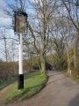
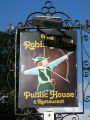
The Robin Hood in Burham is located at the end of a short lane on the north side of Common Road. It has been in existence at least since 1897.Dobson & Taylor list the pub as "[a]n inn on the edge of Buckmore Park, not far from the Rochester-Maidstone road".[1] "Buckmore Park" is labelled "Buckmore Wood" on the O.S. maps listed below. All the maps, the earliest online published in 1897, include the pub under the name "Robin Hood & Little John", which has now been shortened to The Robin Hood, and the pub, like many of those that have survived the pub death in recent years, has become a gastropub.
Gazetteers
Maps
- 25" O.S. map Kent XXXI.2 (c. 1875; surveyed 1865). No Copy in NLS
- 25" O.S. map Kent XXXI.2 (1897; rev. 1895) (georeferenced)
- 25" O.S. map Kent XXXI.2 (1897; rev. 1895)
- 25" O.S. map Kent XXXI.2 (1908; rev. 1907)
- 25" O.S. map Kent XXXI.2 (1934; rev. 1933)
- 25" O.S. map Kent XXXI.2 (1946; rev. 1939)
- 6" O.S. map Kent XXXI (1869; surveyed 1864-65)
- 6" O.S. map Kent XXXI.NW (1898; rev. 1895) (georeferenced)
- 6" O.S. map Kent XXXI.NW (1898; rev. 1895)
- 6" O.S. map Kent XXXI.NW (1910; rev. 1907)
- 6" O.S. map Kent XXXI.NW (c. 1936; rev. 1933)
- 6" O.S. map Kent XXXI.NW (c. 1946; rev. 1938)
- 6" O.S. map Kent XXXI.NW (c. 1949; rev. 1939).
Background
Also see
Notes
Image gallery
Click any image to display it in the lightbox, where you can navigate between images by clicking in the right or left side of the current image.
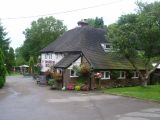
Robin Hood, Burham / Marathon, 1 Aug. 2012, Creative Commons, via Geograph.
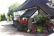
The Robin Hood / From the pub's website.
The Robin Hood, Blue Bell Hill / Chris Whippet, 15 Apr. 2014; Creative Commons, via Geograph
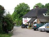
Robin Hood, Blue Bell Hill / Chris Whippet, 11 Jun. 2009; Creative Commons, via Geograph.
Sign of the Robin Hood / Andy Stephenson, 22 Mar. 2009; Creative Commons, via Geograph.
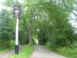
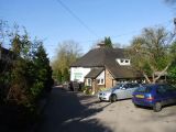
Track leading to The Robin Hood / Marathon, 1 Aug. 2012; Creative Commons, via Geograph.
Sign of the Robin Hood / David Anstiss, 14 Oct. 2012; Creative Commons, via Geograph.


