
Robin Hood (Burham): Difference between revisions
m (Text replacement - "Creative Commons via Geograph" to "Creative Commons, via Geograph") |
rh>Henryfunk mNo edit summary |
||
| Line 29: | Line 29: | ||
== Notes == | == Notes == | ||
<references/> | <references/> | ||
</div> | |||
< | <div id="gallery"> | ||
{{ImgGalleryIntro}} | {{ImgGalleryIntro}} | ||
<gallery widths="195px"> | <gallery widths="195px"> | ||
| Line 43: | Line 44: | ||
File:Bolton, C 19xxa-r.jpg|{{:Bolton, C 19xxa}} / Private collection. | File:Bolton, C 19xxa-r.jpg|{{:Bolton, C 19xxa}} / Private collection. | ||
</gallery> | </gallery> | ||
</div> | |||
{{PnItemNav}} | {{PnItemNav}} | ||
Revision as of 16:40, 15 May 2020
[[File:|thumb|right|500px|Robin Hood, Burham / Marathon, 1 Aug. 2012, Creative Commons, via Geograph.]]
By Henrik Thiil Nielsen, 2018-10-12. Revised by 18.218.55.14, 2020-05-15.
Dobson & Taylor list the pub as "[a]n inn on the edge of Buckmore Park, not far from the Rochester-Maidstone road".[1] "Buckmore Park" is labelled "Buckmore Wood" on the O.S. maps listed below. All the maps, the earliest online published in 1897, include the pub under the name "Robin Hood & Little John", which has now been shortened to The Robin Hood, and the pub, like many of those that have survived the pub death in recent years, has become a gastropub.Template:PnItemQry
Gazetteers
Maps
- 25" O.S. map Kent XXXI.2 (c. 1875; surveyed 1865). No Copy in NLS
- 25" O.S. map Kent XXXI.2 (1897; rev. 1895) (georeferenced)
- 25" O.S. map Kent XXXI.2 (1897; rev. 1895)
- 25" O.S. map Kent XXXI.2 (1908; rev. 1907)
- 25" O.S. map Kent XXXI.2 (1934; rev. 1933)
- 25" O.S. map Kent XXXI.2 (1946; rev. 1939)
- 6" O.S. map Kent XXXI (1869; surveyed 1864-65)
- 6" O.S. map Kent XXXI.NW (1898; rev. 1895) (georeferenced)
- 6" O.S. map Kent XXXI.NW (1898; rev. 1895)
- 6" O.S. map Kent XXXI.NW (1910; rev. 1907)
- 6" O.S. map Kent XXXI.NW (c. 1936; rev. 1933)
- 6" O.S. map Kent XXXI.NW (c. 1946; rev. 1938)
- 6" O.S. map Kent XXXI.NW (c. 1949; rev. 1939).
Background
Notes
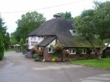
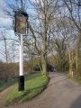
Robin Hood, Burham / Marathon, 1 Aug. 2012, Creative Commons, via Geograph.
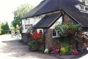
The Robin Hood / From the pub's website.
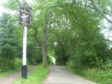
The Robin Hood, Blue Bell Hill / Chris Whippet, 15 Apr. 2014; Creative Commons, via Geograph
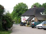
Robin Hood, Blue Bell Hill / Chris Whippet, 11 Jun. 2009; Creative Commons, via Geograph.
Sign of the Robin Hood / Andy Stephenson, 22 Mar. 2009; Creative Commons, via Geograph.
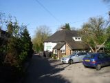
Track leading to The Robin Hood / Marathon, 1 Aug. 2012; Creative Commons, via Geograph.
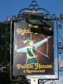
Sign of the Robin Hood / David Anstiss, 14 Oct. 2012; Creative Commons, via Geograph.


