
Robin Hood (Burham): Difference between revisions
mNo edit summary |
mNo edit summary |
||
| Line 1: | Line 1: | ||
__NOTOC__{{PnItemTop|Lat=51.337853|Lon= 0.488217|AdmDiv=Kent|Vicinity=364 Common Road, Blue Bell Hill, Chatham; Burham Common|Type=Public house|Interest=Robin Hood name|Status=Extant|Demonym=English|Riding=|GreaterLondon=|Year=|Aka=The Robin Hood Pub; Robin Hood and Little John|Century= | __NOTOC__{{PnItemTop|Lat=51.337853|Lon= 0.488217|AdmDiv=Kent|Vicinity=364 Common Road, Blue Bell Hill, Chatham; Burham Common|Type=Public house|Interest=Robin Hood name|Status=Extant|Demonym=English|Riding=|GreaterLondon=|Year=1897|Aka=The Robin Hood Pub; Robin Hood and Little John|Century=|Cluster1=|Cluster2=|Cluster3=|Image=geograph-3064333-by-Marathon.jpg|Postcards=Yes|ExtraCat1=Places named after Little John|ExtraCat2=|ExtraCat3=|ExtraCat4=|ExtraCat5=|ExtraLink1=|ExtraLink2=|ExtraLink3=|ExtraLink4=|ExtraLink5=|ExtraLinkName1=|ExtraLinkName2=|ExtraLinkName3=|ExtraLinkName4=|ExtraLinkName5=|GeopointPrefix=|GeopointSuffix=|StatusSuffix=|DatePrefix=|DateSuffix=}} | ||
{{#display_map:{{#var:Coords}}~{{#replace:{{PAGENAME}}|'|'}}|width=34%}}<div class="pnMapLegend">Robin Hood, Burham</div> | {{#display_map:{{#var:Coords}}~{{#replace:{{PAGENAME}}|'|'}}|width=34%}}<div class="pnMapLegend">Robin Hood, Burham</div> | ||
[[File:{{#var:Pnimage}}|thumb|right|500px|Robin Hood, Burham / [http://www.geograph.org.uk/photo/3064333 Marathon, 1 Aug. 2012, Creative Commons via Geograph.]]] | [[File:{{#var:Pnimage}}|thumb|right|500px|Robin Hood, Burham / [http://www.geograph.org.uk/photo/3064333 Marathon, 1 Aug. 2012, Creative Commons via Geograph.]]] | ||
| Line 6: | Line 6: | ||
== Gazetteers == | == Gazetteers == | ||
* {{:Dobson, Richard Barrie 1976a}}, p. 298. | * {{:Dobson, Richard Barrie 1976a}}, p. 298. | ||
<!--== Sources == | <!--== Sources ==--> | ||
== Maps == | == Maps == | ||
* 25" O.S. map ''Kent'' XXXI.2 (''c.'' 1875; surveyed 1865). No Copy in NLS | * 25" O.S. map ''Kent'' XXXI.2 (''c.'' 1875; surveyed 1865). No Copy in NLS | ||
* [https://maps.nls.uk/geo/explore/#zoom=17&lat=51.3382&lon=0.4876&layers=168&b=5 25" O.S. map ''Kent'' XXXI.2 (1897; rev. 1895)] (georeferenced) | * [https://maps.nls.uk/geo/explore/#zoom=17&lat=51.3382&lon=0.4876&layers=168&b=5 25" O.S. map ''Kent'' XXXI.2 (1897; rev. 1895)] (georeferenced) | ||
* [https://maps.nls.uk/view/103678529#zoom=3&lat=4796&lon=8330&layers=BT 25" O.S. map ''Kent'' XXXI.2 (1897; rev. 1895)] | * [https://maps.nls.uk/view/103678529#zoom=3&lat=4796&lon=8330&layers=BT 25" O.S. map ''Kent'' XXXI.2 (1897; rev. 1895)] | ||
* [https://maps.nls.uk/view/103678526#zoom=4&lat=4912&lon=8583&layers=BT 25" O.S. map ''Kent'' XXXI.2 (1908; rev. 1907)] | * [https://maps.nls.uk/view/103678526#zoom=4&lat=4912&lon=8583&layers=BT 25" O.S. map ''Kent'' XXXI.2 (1908; rev. 1907)] | ||
| Line 15: | Line 15: | ||
* [https://maps.nls.uk/view/103678520#zoom=5&lat=5090&lon=8435&layers=BT 25" O.S. map ''Kent'' XXXI.2 (1946; rev. 1939)] | * [https://maps.nls.uk/view/103678520#zoom=5&lat=5090&lon=8435&layers=BT 25" O.S. map ''Kent'' XXXI.2 (1946; rev. 1939)] | ||
* [https://maps.nls.uk/view/102343525#zoom=5&lat=8732&lon=5869&layers=BT 6" O.S. map ''Kent'' XXXI (1869; surveyed 1864-65)] | * [https://maps.nls.uk/view/102343525#zoom=5&lat=8732&lon=5869&layers=BT 6" O.S. map ''Kent'' XXXI (1869; surveyed 1864-65)] | ||
* [https://maps.nls.uk/geo/explore/#zoom=16&lat=51.3382&lon=0.4863&layers=6&b=5 6" O.S. map ''Kent'' XXXI.NW (1898; rev. 1895)] (georeferenced) | * [https://maps.nls.uk/geo/explore/#zoom=16&lat=51.3382&lon=0.4863&layers=6&b=5 6" O.S. map ''Kent'' XXXI.NW (1898; rev. 1895)] (georeferenced) | ||
* [https://maps.nls.uk/view/101429010#zoom=4&lat=4717&lon=6021&layers=BT 6" O.S. map ''Kent'' XXXI.NW (1898; rev. 1895)] | * [https://maps.nls.uk/view/101429010#zoom=4&lat=4717&lon=6021&layers=BT 6" O.S. map ''Kent'' XXXI.NW (1898; rev. 1895)] | ||
* [https://maps.nls.uk/view/101429007#zoom=4&lat=4763&lon=6540&layers=BT 6" O.S. map ''Kent'' XXXI.NW (1910; rev. 1907)] | * [https://maps.nls.uk/view/101429007#zoom=4&lat=4763&lon=6540&layers=BT 6" O.S. map ''Kent'' XXXI.NW (1910; rev. 1907)] | ||
* [https://maps.nls.uk/view/101429004#zoom=4&lat=4758&lon=6262&layers=BT 6" O.S. map ''Kent'' XXXI.NW (''c.'' 1936; rev. 1933)] | * [https://maps.nls.uk/view/101429004#zoom=4&lat=4758&lon=6262&layers=BT 6" O.S. map ''Kent'' XXXI.NW (''c.'' 1936; rev. 1933)] | ||
* [https://maps.nls.uk/view/101429001#zoom=4&lat=4622&lon=6202&layers=BT 6" O.S. map ''Kent'' XXXI.NW (''c.'' 1946; rev. 1938)] | * [https://maps.nls.uk/view/101429001#zoom=4&lat=4622&lon=6202&layers=BT 6" O.S. map ''Kent'' XXXI.NW (''c.'' 1946; rev. 1938)] | ||
* [https://maps.nls.uk/view/101428998#zoom=4&lat=4680&lon=6418&layers=BT 6" O.S. map ''Kent'' XXXI.NW (''c.'' 1949; rev. 1939)] | * [https://maps.nls.uk/view/101428998#zoom=4&lat=4680&lon=6418&layers=BT 6" O.S. map ''Kent'' XXXI.NW (''c.'' 1949; rev. 1939).] | ||
<!--== Discussion ==--> | <!--== Discussion ==--> | ||
== Background == | == Background == | ||
Revision as of 23:08, 12 October 2018
[[File:|thumb|right|500px|Robin Hood, Burham / Marathon, 1 Aug. 2012, Creative Commons via Geograph.]]
By Henrik Thiil Nielsen, 2018-10-12. Revised by Henrik Thiil Nielsen, 2018-10-12.
Gazetteers
Maps
- 25" O.S. map Kent XXXI.2 (c. 1875; surveyed 1865). No Copy in NLS
- 25" O.S. map Kent XXXI.2 (1897; rev. 1895) (georeferenced)
- 25" O.S. map Kent XXXI.2 (1897; rev. 1895)
- 25" O.S. map Kent XXXI.2 (1908; rev. 1907)
- 25" O.S. map Kent XXXI.2 (1934; rev. 1933)
- 25" O.S. map Kent XXXI.2 (1946; rev. 1939)
- 6" O.S. map Kent XXXI (1869; surveyed 1864-65)
- 6" O.S. map Kent XXXI.NW (1898; rev. 1895) (georeferenced)
- 6" O.S. map Kent XXXI.NW (1898; rev. 1895)
- 6" O.S. map Kent XXXI.NW (1910; rev. 1907)
- 6" O.S. map Kent XXXI.NW (c. 1936; rev. 1933)
- 6" O.S. map Kent XXXI.NW (c. 1946; rev. 1938)
- 6" O.S. map Kent XXXI.NW (c. 1949; rev. 1939).
Background
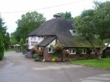
Robin Hood, Burham / Marathon, 1 Aug. 2012, Creative Commons via Geograph.
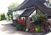
The Robin Hood / From the pub's website.
The Robin Hood, Blue Bell Hill / Chris Whippet, 15 Apr. 2014; Creative Commons via Geograph
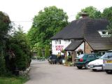
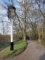
Robin Hood, Blue Bell Hill / Chris Whippet, 11 Jun. 2009; Creative Commons via Geograph.
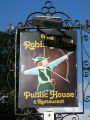
Sign of the Robin Hood / Andy Stephenson, 22 Mar. 2009; Creative Commons via Geograph.
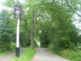
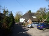
Track leading to The Robin Hood / Marathon, 1 Aug. 2012; Creative Commons via Geograph.
Sign of the Robin Hood / David Anstiss, 14 Oct. 2012; Creative Commons via Geograph.
- Botton, C 19xxa-r.jpg
Botton, C 19xxa / Private collection.


