Robin Hood (Bufflers Holt): Difference between revisions
From International Robin Hood Bibliography
mNo edit summary |
m (Text replacement - "{{PlaceNamesItemAlsoSee}}== Notes ==" to "{{PlaceNamesItemAlsoSee}} == Notes ==") |
||
| (35 intermediate revisions by the same user not shown) | |||
| Line 1: | Line 1: | ||
__NOTOC__ | __NOTOC__{{PlaceNamesItemTop|Lat=52.011604|Lon=-1.029993|AdministrativeDivision=Buckinghamshire|Vicinity=Bufflers Holt, 3.25 km WSW of Buckingham|Type=Public house|Interest=Robin Hood name|Status=Extant|Demonym=|Riding=|GreaterLondon=|Year=1863|Aka=|Century=|Cluster1=|Cluster2=|Cluster3=|Image=Robin Hood (Bufflers Holt, Buckinghamshire).jpg|Postcards=|ExtraCat1=|ExtraCat2=|ExtraCat3=|ExtraCat4=|ExtraCat5=|ExtraLink1=|ExtraLink2=|ExtraLink3=|ExtraLink4=|ExtraLink5=|ExtraLinkName1=|ExtraLinkName2=|ExtraLinkName3=|ExtraLinkName4=|ExtraLinkName5=|GeopointPrefix=|GeopointSuffix=|StatusSuffix=|DatePrefix=|DateSuffix=}} | ||
{{ | {{#display_map:52.011604,-1.029993|width=34%|enablefullscreen=yes}}<div class="pnMapLegend">The pub.</div> | ||
[[File:Robin Hood (Bufflers Holt, Buckinghamshire).jpg|frame|right|The Robin Hood pub and restaurant / [http://www.therobinhoodbuckingham.co.uk The Robin Hood, Buckingham.]]]<div class="no-img"> | |||
<p id="byline">By Henrik Thiil Nielsen, 2013-08-07. Revised by {{#realname:{{REVISIONUSER}}}}, {{REVISIONYEAR}}-{{REVISIONMONTH}}-{{REVISIONDAY2}}.</p> | |||
The Robin Hood pub, now also a restaurant, dates back at least as far as 1863, when it is listed in a trade directory.<ref>[http://pubshistory.com/Buckinghamshire/Buckingham/Traders1863.shtml Buckingham 1863 Dutton, Allen & Co Traders directory.]</ref> This is the Robin Hood inn "2 miles N.W. of Buckingham" listed in Dobson & Taylor.<ref>{{:Dobson, Richard Barrie 1976a}}, p. 295, ''s.n.'' 'The Robin Hood'.</ref> The earliest map to include it that I have found so far is the 6" O.S. map of the area published in 1885 (see Maps section below). | |||
{{#display_map:52.011604,-1.029993|width=34%}}<div class="pnMapLegend"> | |||
[[File:Robin Hood (Bufflers Holt, Buckinghamshire).jpg|frame|right|The Robin Hood pub and restaurant | |||
<p id="byline">By Henrik Thiil Nielsen, 2013-08-07. Revised by {{#realname:{{REVISIONUSER}}}}, {{REVISIONYEAR}}-{{REVISIONMONTH}}-{{REVISIONDAY2}}.</p | |||
The Robin Hood pub | |||
== Gazetteers == | |||
* {{:Dobson, Richard Barrie 1976a}}, p. 295, ''s.n.'' 'The Robin Hood'. | * {{:Dobson, Richard Barrie 1976a}}, p. 295, ''s.n.'' 'The Robin Hood'. | ||
== Sources == | |||
* [http://pubshistory.com/Buckinghamshire/Buckingham/Traders1863.shtml Buckingham 1863 Dutton, Allen & Co Traders directory] | |||
* [http://www.therobinhoodbuckingham.co.uk The Robin Hood (pub website).] | * [http://www.therobinhoodbuckingham.co.uk The Robin Hood (pub website).] | ||
=== Notes | |||
== Maps == | |||
* [https://maps.nls.uk/geo/explore/#zoom=17&lat=52.0118&lon=-1.0289&layers=168&b=5 25" O.S. map ''Buckinghamshire'' XIII.5 (1900; rev. 1899)] (georeferenced) | |||
* [http://maps.nls.uk/view/104180885#zoom=5&lat=1626&lon=13076&layers=BT 25" O.S. map ''Buckinghamshire'' XIII.5 (1900; rev. 1899)] | |||
* [http://maps.nls.uk/view/104180882#zoom=5&lat=1523&lon=12637&layers=BT 25" O.S. map ''Buckinghamshire'' XIII.5 (1923; rev. 1920)] | |||
* [http://maps.nls.uk/view/102340109#zoom=6&lat=5431&lon=4156&layers=BT 6" O.S. map ''Buckinghamshire'' XIII (1885; surveyed 1880)] | |||
* [http://maps.nls.uk/view/101449198#zoom=5&lat=1535&lon=3770&layers=BT 6" O.S. map ''Buckinghamshire'' XIII.NW (1900; rev. 1899)] | |||
* [http://maps.nls.uk/geo/explore/#zoom=17&lat=52.0118&lon=-1.0299&layers=171&b=1 6" O.S. map ''Buckinghamshire'' XIII.NW (1900; rev. 1899)] (georeferenced) | |||
* [http://maps.nls.uk/view/102340106#zoom=6&lat=6229&lon=3625&layers=BT 6" O.S. map ''Buckinghamshire'' XIII (1923; rev. 1920-21)] | |||
* [http://maps.nls.uk/view/101449195#zoom=5&lat=1841&lon=3988&layers=BT 6" O.S. map ''Buckinghamshire'' XIII.NW (1923; rev. 1920-21)] | |||
* [http://maps.nls.uk/view/101449192#zoom=5&lat=1741&lon=3761&layers=BT 6" O.S. map ''Buckinghamshire'' XIII (1952; rev. 1950).] | |||
{{PlaceNamesItemAlsoSee}} | |||
== Notes == | |||
<references/> | <references/> | ||
</div> | </div> | ||
{{ | {{PlaceNamesItemNavigation}} | ||
Latest revision as of 00:44, 6 January 2021
| Locality | |
|---|---|
| Coordinate | 52.011604, -1.029993 |
| Adm. div. | Buckinghamshire |
| Vicinity | Bufflers Holt, 3.25 km WSW of Buckingham |
| Type | Public house |
| Interest | Robin Hood name |
| Status | Extant |
| First Record | 1863 |
The pub.

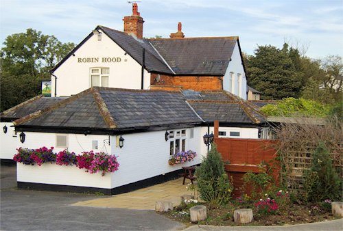
The Robin Hood pub and restaurant / The Robin Hood, Buckingham.
By Henrik Thiil Nielsen, 2013-08-07. Revised by Henrik Thiil Nielsen, 2021-01-06.
The Robin Hood pub, now also a restaurant, dates back at least as far as 1863, when it is listed in a trade directory.[1] This is the Robin Hood inn "2 miles N.W. of Buckingham" listed in Dobson & Taylor.[2] The earliest map to include it that I have found so far is the 6" O.S. map of the area published in 1885 (see Maps section below).
Gazetteers
- Dobson, R. B., ed.; Taylor, J., ed. Rymes of Robyn Hood: an Introduction to the English Outlaw (London, 1976), p. 295, s.n. 'The Robin Hood'.
Sources
Maps
- 25" O.S. map Buckinghamshire XIII.5 (1900; rev. 1899) (georeferenced)
- 25" O.S. map Buckinghamshire XIII.5 (1900; rev. 1899)
- 25" O.S. map Buckinghamshire XIII.5 (1923; rev. 1920)
- 6" O.S. map Buckinghamshire XIII (1885; surveyed 1880)
- 6" O.S. map Buckinghamshire XIII.NW (1900; rev. 1899)
- 6" O.S. map Buckinghamshire XIII.NW (1900; rev. 1899) (georeferenced)
- 6" O.S. map Buckinghamshire XIII (1923; rev. 1920-21)
- 6" O.S. map Buckinghamshire XIII.NW (1923; rev. 1920-21)
- 6" O.S. map Buckinghamshire XIII (1952; rev. 1950).
Also see
Notes
