
Robin Hood (Brierley Hill)
[[File:|thumb|right|500px|The Robin Hood, Merry Hill / Brian Clift, 1 June 1975;[1] Creative Commons, via Geograph.]]
By Henrik Thiil Nielsen, 2020-10-23. Revised by Henrik Thiil Nielsen, 2020-10-23.
The Robin Hood in Brierley Hill was situated on the west side of Pedmore Road (A4036; Merry Hill) at a currently unoccupied plot between the latter road and an unnamed road snaking roughly north-south past Brierley Hill Shopping Centre.
The site of the pub straddles a footpath, oriented NW–SE, which connects those streets. The now demoilished pub is included in O.S. maps dating from 1884 to 1947 (see below). No doubt the long-defunct New Robin Hood Colliery on the east side of Pedmore Road was named after the pub. So also were, directly or indirectly, several other localities in Brierley Hill. See Brierley Hill place-name cluster.
https://www.setlist.fm/venue/the-robin-hood-brierley-hill-england-5bd75308.html
Gazetteers
- Not included in Dobson, R. B., ed.; Taylor, J., ed. Rymes of Robyn Hood: an Introduction to the English Outlaw (London, 1976), pp. 293-311.
Maps
- 25" O.S. map Staffordshire LXXI.7 (1884; surveyed 1881–82)
- 25" O.S. map Worcestershire IV.7 (1903; rev. 1901) (georeferenced)
- 25" O.S. map Worcestershire IV.7 (1903; rev. 1901)
- 25" O.S. map Staffordshire LXXI.7 (1920; rev. 1914)
- 25" O.S. map Staffordshire LXXI.7 (1947; rev. 1939)
- 6" O.S. map Worcestershire IV.NE (1887; surveyed 1881–82)
- 6" O.S. map Staffordshire LXXI.NE (1904; rev. 1901) (georeferenced)
- 6" O.S. map Staffordshire LXXI.NE (1904; rev. 1901)
- 6" O.S. map Staffordshire LXXI (1921; rev. 1914)
- 6" O.S. map Staffordshire LXXI.NE (1921; rev. 1914)
- 6" O.S. map Staffordshire LXXI.NE (c. 1946; rev. 1938).
Notes
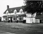
The Robin Hood, Merry Hill / Brian Clift, 1 June 1975; Creative Commons, via Geograph.
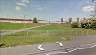
The site of the Robin Hood / Google Earth Street View.

