Robin Hood (Brierley Hill): Difference between revisions
mNo edit summary |
m (Text replacement - "ImgGalleryIntro" to "ImageGalleryIntroduction") |
||
| (14 intermediate revisions by the same user not shown) | |||
| Line 1: | Line 1: | ||
__NOTOC__{{ | __NOTOC__{{PlaceNamesItemTop|Lat=52.4796|Lon=-2.1068|AdministrativeDivision=Staffordshire|Vicinity=Merry Hill; immediately W of Pedmore Road (A4036); adjacent to Brierley Hill Shopping Centre|Type=Public house|Interest=Robin Hood name| | ||
Status=Defunct|Demonym=|Riding=|GreaterLondon=|Year=1884|Aka=Robin Hood Inn|Century=|Cluster1=Brierley Hill|Cluster2=|Cluster3=|Image=geograph-1117934-by-Brian-Clift.jpg|Postcards=|ExtraCat1=|ExtraCat2=|ExtraCat3=|ExtraCat4=|ExtraCat5=|ExtraLink1=|ExtraLink2=|ExtraLink3=|ExtraLink4=|ExtraLink5=|ExtraLinkName1=|ExtraLinkName2=|ExtraLinkName3=|ExtraLinkName4=|ExtraLinkName5=|GeopointPrefix=|GeopointSuffix=|VicinitySuffix=|StatusSuffix=|DatePrefix=|DateSuffix=}} | Status=Defunct|Demonym=|Riding=|GreaterLondon=|Year=1884|Aka=Robin Hood Inn|Century=|Cluster1=Brierley Hill|Cluster2=|Cluster3=|Image=geograph-1117934-by-Brian-Clift.jpg|Postcards=|ExtraCat1=|ExtraCat2=|ExtraCat3=|ExtraCat4=|ExtraCat5=|ExtraLink1=|ExtraLink2=|ExtraLink3=|ExtraLink4=|ExtraLink5=|ExtraLinkName1=|ExtraLinkName2=|ExtraLinkName3=|ExtraLinkName4=|ExtraLinkName5=|GeopointPrefix=|GeopointSuffix=|VicinitySuffix=|StatusSuffix=|DatePrefix=|DateSuffix=}} | ||
{{#display_map:{{#var:Coords}}~{{#replace:{{PAGENAME}}|'|'}}|width=34%}}<div class="pnMapLegend">The New Robin Hood Colliery was located in the area now occupied by Nottingham Way.</div> | {{#display_map:{{#var:Coords}}~{{#replace:{{PAGENAME}}|'|'}}|width=34%|fullscreen=yes}}<div class="pnMapLegend">The New Robin Hood Colliery was located in the area now occupied by Nottingham Way.</div> | ||
[[File:{{#var: | [[File:{{#var:Image}}|thumb|right|500px|The Robin Hood, Merry Hill / [https://m.geograph.org.uk/photo/1117934 Brian Clift, 1 June 1975; Creative Commons, via Geograph.]]] | ||
<p id="byline">By Henrik Thiil Nielsen, 2020-10-23. Revised by {{#realname:{{REVISIONUSER}}}}, {{REVISIONYEAR}}-{{REVISIONMONTH}}-{{REVISIONDAY2}}.</p><div class="no-img"> | <p id="byline">By Henrik Thiil Nielsen, 2020-10-23. Revised by {{#realname:{{REVISIONUSER}}}}, {{REVISIONYEAR}}-{{REVISIONMONTH}}-{{REVISIONDAY2}}.</p><div class="no-img"> | ||
The Robin Hood in Brierley Hill was situated on the west side of Pedmore Road (A4036; Merry Hill) at a | The Robin Hood in Brierley Hill was situated on the west side of Pedmore Road (A4036; Merry Hill) at a currently unoccupied plot between the latter road and an unnamed road snaking roughly north–south past Brierley Hill Shopping Centre. | ||
The site of the pub straddles a footpath, oriented NW–SE, which connects those streets. The pub is included in O.S. maps dating from 1884 to 1947 (see below). | The site of the pub straddles a footpath, oriented NW–SE, which connects those streets. The now demolished pub is included in O.S. maps dating from 1884 to 1947 (see below). It was still in business in 2003.<ref>[https://www.setlist.fm/venue/the-robin-hood-brierley-hill-england-5bd75308.html setList.fm: The Robin Hood Brierley Hill Concert Setlists.]</ref> There was a concert room at the back of the pub.<ref name="flickr">[https://www.flickr.com/photos/brianac37/5639928243/ Flickr: Robin Hood (demolished).]</ref> No doubt the long-defunct [[New Robin Hood Colliery (Brierley Hill)|New Robin Hood Colliery]] on the east side of Pedmore Road was named after the pub. So also were presumably, directly or indirectly, several other localities in Brierley Hill. See [[Brierley Hill place-name cluster]]. The black and white photo of the pub uploaded to Geograph by Brian Clift is dated 1 June 1975,<ref>[https://m.geograph.org.uk/photo/1117934 Geograph: SO9286 – The Robin Hood, Merry Hill]</ref> but the same photo uploaded to Flickr, probably also by the photographer himself, is dated 1967.<ref name="flickr"/> | ||
{{ | {{PlaceNamesItemAllusionsAndRecords}} | ||
== Gazetteers == | == Gazetteers == | ||
* Not included in {{:Dobson, Richard Barrie 1976a}}, pp. 293-311. | * Not included in {{:Dobson, Richard Barrie 1976a}}, pp. 293-311. | ||
== Sources == | |||
* [https://www.flickr.com/photos/brianac37/5639928243/ Flickr: Robin Hood (demolished)] | |||
* [https://www.setlist.fm/venue/the-robin-hood-brierley-hill-england-5bd75308.html setList.fm: The Robin Hood Brierley Hill Concert Setlists.] | |||
== Maps == | == Maps == | ||
* [https://maps.nls.uk/view/115476343#zoom=5&lat=7328&lon=7647&layers=BT 25" O.S. map ''Staffordshire'' LXXI.7 (1884; surveyed 1881–82)] | * [https://maps.nls.uk/view/115476343#zoom=5&lat=7328&lon=7647&layers=BT 25" O.S. map ''Staffordshire'' LXXI.7 (1884; surveyed 1881–82)] | ||
| Line 30: | Line 33: | ||
<!--== Brief mention == | <!--== Brief mention == | ||
* --> | * --> | ||
{{ | {{PlaceNamesItemAlsoSee}} | ||
== Notes == | == Notes == | ||
| Line 37: | Line 40: | ||
</div> | </div> | ||
{{ | {{ImageGalleryIntroduction}} | ||
<gallery widths="195px"> | <gallery widths="195px"> | ||
geograph-1117934-by-Brian-Clift.jpg|The Robin Hood, Merry Hill / [https://m.geograph.org.uk/photo/1117934 Brian Clift, 1 June 1975; Creative Commons, via Geograph.] | geograph-1117934-by-Brian-Clift.jpg|The Robin Hood, Merry Hill / [https://m.geograph.org.uk/photo/1117934 Brian Clift, 1 June 1975; Creative Commons, via Geograph.] | ||
| Line 44: | Line 47: | ||
{{ | {{PlaceNamesItemNavigation}} | ||
Latest revision as of 13:53, 7 January 2021
| Locality | |
|---|---|
| Coordinate | 52.4796, -2.1068 |
| Adm. div. | Staffordshire |
| Vicinity | Merry Hill; immediately W of Pedmore Road (A4036); adjacent to Brierley Hill Shopping Centre |
| Type | Public house |
| Interest | Robin Hood name |
| Status | Defunct |
| First Record | 1884 |
| A.k.a. | Robin Hood Inn |

By Henrik Thiil Nielsen, 2020-10-23. Revised by Henrik Thiil Nielsen, 2021-01-07.
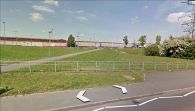
The Robin Hood in Brierley Hill was situated on the west side of Pedmore Road (A4036; Merry Hill) at a currently unoccupied plot between the latter road and an unnamed road snaking roughly north–south past Brierley Hill Shopping Centre.
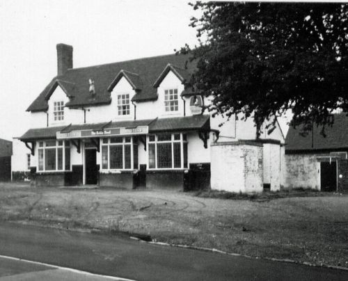
The site of the pub straddles a footpath, oriented NW–SE, which connects those streets. The now demolished pub is included in O.S. maps dating from 1884 to 1947 (see below). It was still in business in 2003.[1] There was a concert room at the back of the pub.[2] No doubt the long-defunct New Robin Hood Colliery on the east side of Pedmore Road was named after the pub. So also were presumably, directly or indirectly, several other localities in Brierley Hill. See Brierley Hill place-name cluster. The black and white photo of the pub uploaded to Geograph by Brian Clift is dated 1 June 1975,[3] but the same photo uploaded to Flickr, probably also by the photographer himself, is dated 1967.[2]
Gazetteers
- Not included in Dobson, R. B., ed.; Taylor, J., ed. Rymes of Robyn Hood: an Introduction to the English Outlaw (London, 1976), pp. 293-311.
Sources
Maps
- 25" O.S. map Staffordshire LXXI.7 (1884; surveyed 1881–82)
- 25" O.S. map Worcestershire IV.7 (1903; rev. 1901) (georeferenced)
- 25" O.S. map Worcestershire IV.7 (1903; rev. 1901)
- 25" O.S. map Staffordshire LXXI.7 (1920; rev. 1914)
- 25" O.S. map Staffordshire LXXI.7 (1947; rev. 1939)
- 6" O.S. map Worcestershire IV.NE (1887; surveyed 1881–82)
- 6" O.S. map Staffordshire LXXI.NE (1904; rev. 1901) (georeferenced)
- 6" O.S. map Staffordshire LXXI.NE (1904; rev. 1901)
- 6" O.S. map Staffordshire LXXI (1921; rev. 1914)
- 6" O.S. map Staffordshire LXXI.NE (1921; rev. 1914)
- 6" O.S. map Staffordshire LXXI.NE (c. 1946; rev. 1938).
Also see
Notes
Image gallery
Click any image to display it in the lightbox, where you can navigate between images by clicking in the right or left side of the current image.
The Robin Hood, Merry Hill / Brian Clift, 1 June 1975; Creative Commons, via Geograph.


