
Robin Hood (Brentwood): Difference between revisions
m (Text replacement - "<div class="no-img"><p id="byline">" to "<div class="no-img"> <p id="byline">") |
mNo edit summary |
||
| Line 4: | Line 4: | ||
[[File:Robin hood brentwood essex google earth.jpg|thumb|right|500px|The Robin Hood has lost the Hood and is now the robin ''sans'' capitals / Google Earth Street View.]]<div class="no-img"> | [[File:Robin hood brentwood essex google earth.jpg|thumb|right|500px|The Robin Hood has lost the Hood and is now the robin ''sans'' capitals / Google Earth Street View.]]<div class="no-img"> | ||
<p id="byline">By Henrik Thiil Nielsen, 2016-06-26. Revised by {{#realname:{{REVISIONUSER}}}}, {{REVISIONYEAR}}-{{REVISIONMONTH}}-{{REVISIONDAY2}}.</p> | <p id="byline">By Henrik Thiil Nielsen, 2016-06-26. Revised by {{#realname:{{REVISIONUSER}}}}, {{REVISIONYEAR}}-{{REVISIONMONTH}}-{{REVISIONDAY2}}.</p> | ||
On Chapman & André's 1777 map of Essex (see Maps section and detail of map below), the Robin Hood, a public house, is indicated just north of Brentwood by the side of a road now named Ongar Road. There was an advertisement for the pub in the ''Chelmsford Chronicle'' for 20 Jan.<ref name="millerchristy">{{:Christy, Miller 1887a}}, p. 138.</ref> On a 6" O.S. map of the area based on surveying carried out in 1866, the pub is indicated as "Robin Hood", while on an O.S. 6" map based on surveying done in 1895 the pub appears as "Robin Hood & Little John" (see Maps section below). That was also the form of the name displayed on its sign in 1887 according to Miller Christy.<ref name="millerchristy"/> The pub is still there but is now named the Robin (the feathered kind). In the meantime it has bequeathed its former name to adjacent [[Robin Hood Road (Brentwood)|Robin Hood Road]]. Information on publicans gleaned from trade directories etc. from the period 1828–1937 can be found at | On Chapman & André's 1777 map of Essex (see Maps section and detail of map below), the Robin Hood, a public house, is indicated just north of Brentwood by the side of a road now named Ongar Road. There was an advertisement for the pub in the ''Chelmsford Chronicle'' for 20 Jan.<ref name="millerchristy">{{:Christy, Miller 1887a}}, p. 138.</ref> On a 6" O.S. map of the area based on surveying carried out in 1866, the pub is indicated as "Robin Hood", while on an O.S. 6" map based on surveying done in 1895 the pub appears as "Robin Hood & Little John" (see Maps section below). That was also the form of the name displayed on its sign in 1887 according to Miller Christy.<ref name="millerchristy"/> The pub is still there but is now named the Robin (the feathered kind). In the meantime it has bequeathed its former name to adjacent [[Robin Hood Road (Brentwood)|Robin Hood Road]]. Information on publicans gleaned from trade directories etc. from the period 1828–1937 can be found at the Pub Wiki (see Sources below).{{PnItemQry}} | ||
== Gazetteers == | == Gazetteers == | ||
* Not included in {{:Dobson, Richard Barrie 1976a}}, pp. 293-311. | * Not included in {{:Dobson, Richard Barrie 1976a}}, pp. 293-311. | ||
| Line 10: | Line 10: | ||
== Sources == | == Sources == | ||
* {{:Christy, Miller 1887a}}, p. 138. | * {{:Christy, Miller 1887a}}, p. 138. | ||
* [https:// | * [https://pubwiki.co.uk/EssexPubs/Brentwood/robin.shtml Pub Wiki: Robin Hood & Little John, Ongar Road, Brentwood.]<ref>Also see there [https://pubwiki.co.uk/Essex1937/Essex1937Ro.shtml The Essex 1937 Pub Directory – Ro].</ref> | ||
== Maps == | == Maps == | ||
Revision as of 07:48, 3 September 2020


By Henrik Thiil Nielsen, 2016-06-26. Revised by Henrik Thiil Nielsen, 2020-09-03.
On Chapman & André's 1777 map of Essex (see Maps section and detail of map below), the Robin Hood, a public house, is indicated just north of Brentwood by the side of a road now named Ongar Road. There was an advertisement for the pub in the Chelmsford Chronicle for 20 Jan.[1] On a 6" O.S. map of the area based on surveying carried out in 1866, the pub is indicated as "Robin Hood", while on an O.S. 6" map based on surveying done in 1895 the pub appears as "Robin Hood & Little John" (see Maps section below). That was also the form of the name displayed on its sign in 1887 according to Miller Christy.[1] The pub is still there but is now named the Robin (the feathered kind). In the meantime it has bequeathed its former name to adjacent Robin Hood Road. Information on publicans gleaned from trade directories etc. from the period 1828–1937 can be found at the Pub Wiki (see Sources below).Template:PnItemQry
Gazetteers
- Not included in Dobson, R. B., ed.; Taylor, J., ed. Rymes of Robyn Hood: an Introduction to the English Outlaw (London, 1976), pp. 293-311.
Sources
- Christy, Miller. The Trade Signs of Essex: A Popular Account of the Origins and Meanings of the Public House & Other Signs Now or Formerly Found in the County of Essex (Chelmsford; London, 1887), p. 138.
- Pub Wiki: Robin Hood & Little John, Ongar Road, Brentwood.[2]
Maps
- Chapman, John, cartog.; André, Peter, cartog. A Map of the County of Essex: from an Actual Survey Taken in MDCCLXXII, LXXIII & MDCCLXXIV (London, 1777), plate XVII.
- 6" O.S. map of Essex LXVII (1881; surveyed 1866)
- 6" O.S. map of Essex LXVII.NE (1898; surveyed 1895.)
Notes
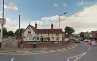
The Robin Hood has lost the Hood and is now the robin sans capitals / Google Earth Street View.
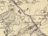
The Robin Hood is indicated just north of Brentwood / From superb scan of entire map at Biblioteca Virtual del Patrimoni Bibliogràfico (click to enlarge).
