
Robin Hood (Boston): Difference between revisions
m (Text replacement - "width=34%|service=leaflet|" to "service=leaflet|width=34%|") |
m (Text replacement - "|service=leaflet|" to "|") |
||
| Line 1: | Line 1: | ||
__NOTOC__{{PnItemTop|Lat=52.973264|Lon=-0.024763|AdmDiv=Lincolnshire|Vicinity=104 High Street, Boston|Type=Public house|Interest=Robin Hood name|Status=Extant|Demonym=|Riding=|GreaterLondon=|Year=1861|Aka=|Century=|Cluster1=|Cluster2=Boston|Cluster3=|Image=geograph-3675752-by-Dave-Hitchborne.jpg|Postcards=|ExtraCat1=|ExtraCat2=|ExtraCat3=|ExtraCat4=|ExtraCat5=|ExtraLink1=|ExtraLink2=|ExtraLink3=|ExtraLink4=|ExtraLink5=|ExtraLinkName1=|ExtraLinkName2=|ExtraLinkName3=|ExtraLinkName4=|ExtraLinkName5=|GeopointPrefix=|GeopointSuffix=|StatusSuffix=|DatePrefix=|DateSuffix=}} | __NOTOC__{{PnItemTop|Lat=52.973264|Lon=-0.024763|AdmDiv=Lincolnshire|Vicinity=104 High Street, Boston|Type=Public house|Interest=Robin Hood name|Status=Extant|Demonym=|Riding=|GreaterLondon=|Year=1861|Aka=|Century=|Cluster1=|Cluster2=Boston|Cluster3=|Image=geograph-3675752-by-Dave-Hitchborne.jpg|Postcards=|ExtraCat1=|ExtraCat2=|ExtraCat3=|ExtraCat4=|ExtraCat5=|ExtraLink1=|ExtraLink2=|ExtraLink3=|ExtraLink4=|ExtraLink5=|ExtraLinkName1=|ExtraLinkName2=|ExtraLinkName3=|ExtraLinkName4=|ExtraLinkName5=|GeopointPrefix=|GeopointSuffix=|StatusSuffix=|DatePrefix=|DateSuffix=}} | ||
{{#display_map:{{#var:Coords}}~{{#replace:{{PAGENAME}}|'|'}} | {{#display_map:{{#var:Coords}}~{{#replace:{{PAGENAME}}|'|'}}|width=34%|enablefullscreen=yes}}<div class="pnMapLegend">The Robin Hood.</div> | ||
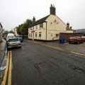
[[File:{{#var:Pnimage}}|thumb|right|350px|The Robin Hood, High Street, Boston / [http://www.geograph.org.uk/photo/3675662 Dave Hitchborne, 25 Sep. 2013, Creative Commons, via Geograph.]]]<div class="no-img"> | [[File:{{#var:Pnimage}}|thumb|right|350px|The Robin Hood, High Street, Boston / [http://www.geograph.org.uk/photo/3675662 Dave Hitchborne, 25 Sep. 2013, Creative Commons, via Geograph.]]]<div class="no-img"> | ||
<p id="byline">By Henrik Thiil Nielsen, 2013-08-07. Revised by {{#realname:{{REVISIONUSER}}}}, {{REVISIONYEAR}}-{{REVISIONMONTH}}-{{REVISIONDAY2}}.</p> | <p id="byline">By Henrik Thiil Nielsen, 2013-08-07. Revised by {{#realname:{{REVISIONUSER}}}}, {{REVISIONYEAR}}-{{REVISIONMONTH}}-{{REVISIONDAY2}}.</p> | ||
Revision as of 13:45, 22 December 2020
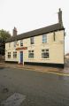
[[File:|thumb|right|350px|The Robin Hood, High Street, Boston / Dave Hitchborne, 25 Sep. 2013, Creative Commons, via Geograph.]]
By Henrik Thiil Nielsen, 2013-08-07. Revised by Henrik Thiil Nielsen, 2020-12-22.
The Robin Hood on High Street in Boston, Lincolnshire, was in existence by 1861. It evidently underwent a change of name in the not too distant past and for a while traded as "PJ's Pie Pub", but by 25 Sep. 2013 it had again become the Robin Hood.[1] Information on publicans for the years 1861 to 1905 can be found at UK Pub History.[2]Template:PnItemQry
Gazetteers
- Not included in Dobson, R. B., ed.; Taylor, J., ed. Rymes of Robyn Hood: an Introduction to the English Outlaw (London, 1976), pp. 293-311.
Sources
- Geograph: High Street, Boston; by Dave Hitchborne
- UK Pub History: Robin Hood, 104 High street, Boston, Lincolnshire.
Maps
- 25" O.S. map Lincolnshire CIX.13 (1905; rev. 1903) (georeferenced)
- 25" O.S. map Lincolnshire CIX.13 (1905; rev. 1903)
- 25" O.S. map Lincolnshire CIX.13 (1889; surveyed 1888)
- 6" O.S. map Lincolnshire CIX.SW (1906; rev. 1903) (georeferenced)
- 6" O.S. map Lincolnshire CIX.SW (1906; rev. 1903)
- 6" O.S. map Lincolnshire CIX.SW (c. 1947; rev. 1938)
- 6" O.S. map Lincolnshire CIX.SW (1951; rev. 1946).
Background
Notes
The Robin Hood, High Street, Boston / Dave Hitchborne, 25 Sep. 2013, Creative Commons, via Geograph.
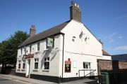
The Robin Hood, High Street, Boston / Dave Hitchborne, 25 Sep. 2013, Creative Commons, via Geograph.
The Robin Hood / Bateman's: Robin Hood.


.jpg)