
Robin Hood (Attercliffe) (3): Difference between revisions
m (Text replacement - "|service=leaflet}}" to "|service=leaflet|enablefullscreen=yes}}") |
m (→Maps) |
||
| Line 14: | Line 14: | ||
== Maps == | == Maps == | ||
* [https://maps.nls.uk/geo/explore/#zoom=18&lat=53.3918&lon=-1.4374&layers=168&b=5 25" O.S. map ''Yorkshire'' CCXCV.5 (1905; rev. 1901-1903)] (georeferenced) | * [https://maps.nls.uk/geo/explore/#zoom=18&lat=53.3918&lon=-1.4374&layers=168&b=5 25" O.S. map ''Yorkshire'' CCXCV.5 (1905; rev. 1901-1903)] (georeferenced) | ||
* [https://maps.nls.uk/view/125651362#zoom=5&lat=11025&lon=1815&layers=BT 25" O.S. map ''Yorkshire'' CCXCV.5 (1905; rev. 1901-1903)] | * [https://maps.nls.uk/view/125651362#zoom=5&lat=11025&lon=1815&layers=BT 25" O.S. map ''Yorkshire'' CCXCV.5 (1905; rev. 1901-1903)] | ||
* [https://maps.nls.uk/view/125651365#zoom=5&lat=10862&lon=1550&layers=BT 25" O.S. map ''Yorkshire'' CCXCV.5 (1923; rev. 1921)] | * [https://maps.nls.uk/view/125651365#zoom=5&lat=10862&lon=1550&layers=BT 25" O.S. map ''Yorkshire'' CCXCV.5 (1923; rev. 1921)] | ||
| Line 28: | Line 28: | ||
* [https://maps.nls.uk/view/100950113#zoom=6&lat=3796&lon=1204&layers=BT 6" O.S. map ''Yorkshire'' CCXCV.NW (1949; rev. 1948).] | * [https://maps.nls.uk/view/100950113#zoom=6&lat=3796&lon=1204&layers=BT 6" O.S. map ''Yorkshire'' CCXCV.NW (1949; rev. 1948).] | ||
{{PnItemAlsoSee}} | {{PnItemAlsoSee}} | ||
== Notes == | == Notes == | ||
<references/> | <references/> | ||
Revision as of 17:59, 7 June 2019
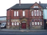
[[File:|thumb|right|500px|Robin Hood and his merry drinkers have been replaced by liberated couples and singles / Submitted by Will Larter to the now lost 'Lost Pubs Project'.]]
By Henrik Thiil Nielsen, 2013-08-07. Revised by Henrik Thiil Nielsen, 2019-06-07.
This pub started its existence on 1 Attercliffe Road in 1825, then moved to a now lost Attercliffe street named Carlton Road, before finally at some point between 1883 and 1887 settling at 548 Attercliffe Road.[1] It still existed in 1951. Currently the precincts are occupied by La Chambre which advertizes itself as "The top class venue for liberated adults". Such a place of course has to have a French name. On the pavement in front is a poster perhaps not inappropriately advertizing "The Most Advanced Mattress in the World", while just around the corner Artan Steel Alloys Ltd. survives to remind us of Sheffield's more glorious past.Template:PnItemQry
Gazetteers
- Lost Pubs Project (at the Internet Archive).
Sources
- Pubs N to S - Keepers, Picture-links
- UK Pub History: Robin Hood, 548 Attercliffe Road, Sheffield, Yorkshire.
Maps
- 25" O.S. map Yorkshire CCXCV.5 (1905; rev. 1901-1903) (georeferenced)
- 25" O.S. map Yorkshire CCXCV.5 (1905; rev. 1901-1903)
- 25" O.S. map Yorkshire CCXCV.5 (1923; rev. 1921)
- 25" O.S. map Yorkshire CCXCV.5 (1937; rev. 1935)
- 6" O.S. map Yorkshire 295 (1855; surveyed 1850-51)
- 6" O.S. map Yorkshire CCXCV.NW (1894; surveyed 1889-91)
- 6" O.S. map Yorkshire CCXCV.NW (1906; rev. 1901-1903) (georeferenced)
- 6" O.S. map Yorkshire CCXCV.NW (1906; rev. 1901-1903)
- 6" O.S. map Yorkshire CCXCV (1924; rev. 1921-22)
- 6" O.S. map Yorkshire CCXCV.NW (1924; rev. 1921)
- 6" O.S. map Yorkshire CCXCV.NW (1938; rev. 1938)
- 6" O.S. map Yorkshire CCXCV.NW (1940; rev. 1935)
- 6" O.S. map Yorkshire CCXCV.NW (1949; rev. 1948).
Notes
The former Robin Hood / Submitted by Will Larter to the now lost 'Lost Pubs Project'.
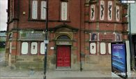
La Chambre / Google Earth Street View.
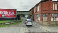
La Chambre / Google Earth Street View.


