
Robin Hood (Attercliffe) (2): Difference between revisions
m (Text replacement - "No Copy in NLS" to "No copy in NLS") |
m (Text replacement - "UK Pub History" to "Pub History") |
||
| Line 15: | Line 15: | ||
== Sources == | == Sources == | ||
* [https://www.sheffieldhistory.co.uk/forums/topic/3531-pubs-n-to-s-keepers-picture-links/?page=19 Sheffield History: Pubs N to S - Keepers, Picture-links] | * [https://www.sheffieldhistory.co.uk/forums/topic/3531-pubs-n-to-s-keepers-picture-links/?page=19 Sheffield History: Pubs N to S - Keepers, Picture-links] | ||
* [https://pubhistory.co.uk//Yorkshire/SheffieldR/RobinHoodAttercliffe.shtml | * [https://pubhistory.co.uk//Yorkshire/SheffieldR/RobinHoodAttercliffe.shtml Pub History: Robin Hood, 548 Attercliffe Road, Sheffield, Yorkshire.] | ||
== Maps == | == Maps == | ||
Latest revision as of 15:27, 5 May 2022
| Locality | |
|---|---|
| Coordinate | 53.3926, -1.4362 |
| Adm. div. | West Riding of Yorkshire |
| Vicinity | N of Heppenstall Lane, S of Oakes Green, W of Kimberley Street, in Attercliffe, Sheffield |
| Type | Public house |
| Interest | Robin Hood name |
| Status | Defunct |
| First Record | 1859 |
| A.k.a. | Robin Hood |

By Henrik Thiil Nielsen, 2018-10-24. Revised by Henrik Thiil Nielsen, 2022-05-05.
84 Carlton Road (Attercliffe, Sheffield) was the second of four addresses for one of Sheffield's Robin Hood pubs. It had moved here from its prior address of 1 Attercliffe Road by 1859. It was still at 84 Carlton Road in 1868, but by 1876 the address had changed to 140 Carlton Road, where it remained at least until 1883, moving by 1887 to 548 Attercliffe Road, where it seems to have stayed for the rest of its somewhat peripatetic existence.
It is important to note that Carlton Road was a now lost street in Attercliffe, not that in Wadsley which was only constructed some time between 1902 and 1920.[1] Carlton Road in Attercliffe was situated in the area now bounded by Heppenstall Lane, St Charles Street, Oakes Green, and Kimberley Street. A short road, not named on the maps and thus most probably considered part of Carlton Road, connected it with Kimberley Street and in turn with the bit of road which leads from the latter to Attercliffe Road. See the adapted Google satellite image in the gallery below. Whatever the exact location of the pub on this now lost road, it can have been only 50 to 100 metres from its future address at 548 Attercliffe Road. The coordinate on the Google map and in the info box is that of a point fairly close to the centre of the now lost street. Further research would be required to determine whether the (apparent) move from 84 to 140 Carlton Road was a real change of location or the result of renumbering of the houses. IRHB currently does not have separate entries for 84 and 140 Carlton Road.
The old wrinkled and bruised photo shown on this page was added to a thread on the Robin Hood pub (at its various addresses) by a user who could not remember where he found it. I have done a good deal of doctoring on it. The image submitted looked even worse. If the subject were the Robin Hood at 1 Attercliffe Road, this would be a quite early daguerrotype. The photo clearly does not show the building at 548 Attercliffe Road, so if it is indeed a photo of the Robin Hood, this would most likely be its Carlton Road incarnation (or one of them).
Gazetteers
- Not included in Dobson, R. B., ed.; Taylor, J., ed. Rymes of Robyn Hood: an Introduction to the English Outlaw (London, 1976), pp. 293-11.
Sources
- Sheffield History: Pubs N to S - Keepers, Picture-links
- Pub History: Robin Hood, 548 Attercliffe Road, Sheffield, Yorkshire.
Maps
Carlton Road in Attercliffe
- 25" O.S. map Yorkshire CCXCV.1 (c. 1894; surveyed c. 1889-92). No copy in NLS
- 25" O.S. map Yorkshire CCXCV.1 (1905; rev. 1901-1903) (georeferenced)
- 25" O.S. map Yorkshire CCXCV.1 (1905; rev. 1901-1903)
- 25" O.S. map Yorkshire CCXCV.1 (1923; rev. 1921)
- 25" O.S. map Yorkshire CCXCV.1 (1937; rev. 1935)
- 25" O.S. map Yorkshire CCXCV.5 (1893; surveyed 1889-91)
- 25" O.S. map Yorkshire CCXCV.5 (1905; rev. 1901-1903)
- 25" O.S. map Yorkshire CCXCV.5 (1923; rev. 1921)
- 25" O.S. map Yorkshire CCXCV.5 (1937; rev. 1935)
- 6" O.S. map Yorkshire 295 (1855; surveyed 1850-51)
- 6" O.S. map Yorkshire CCXCV.NW (1894; surveyed 1889-91)
- 6" O.S. map Yorkshire CCXCV.NW (1906; rev. 1901-1903) (georeferenced)
- 6" O.S. map Yorkshire CCXCV.NW (1906; rev. 1901-1903)
- 6" O.S. map Yorkshire CCXCV (1924; rev. 1921-22)
- 6" O.S. map Yorkshire CCXCV.NW (1924; rev. 1921)
- 6" O.S. map Yorkshire CCXCV.NW (1938; rev. 1938)
- 6" O.S. map Yorkshire CCXCV.NW (1940; rev. 1935)
- 6" O.S. map Yorkshire CCXCV.NW (1949; rev. 1948).
Carlton Road in Wadsley
- 25" O.S. map Yorkshire CCLXXXVIII.15 (1905; rev. 1901-1902)
- 25" O.S. map Yorkshire CCLXXXVIII.15 (1923; rev. 1920).
Background
Also see
- Sheffield place-name cluster
- Attercliffe place-name cluster
- Places named after Little John
- Robin Hood (Attercliffe) (1)
- Robin Hood (Attercliffe) (3)
- Public houses named after Robin Hood.
Notes
Image gallery
Click any image to display it in the lightbox, where you can navigate between images by clicking in the right or left side of the current image.
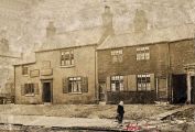
The Robin Hood / Sheffield History Forum.
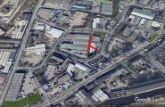
Carlton Road, Attercliffe, indicated in red / Adapted from Google Earth Street View.
