
Robin Hood (Appley Bridge): Difference between revisions
m (Text replacement - "|service=leaflet}}" to "|service=leaflet|enablefullscreen=yes}}") |
m (→Maps) |
||
| Line 11: | Line 11: | ||
== Maps == | == Maps == | ||
* [https://maps.nls.uk/view/126520139#zoom=3&lat=2057&lon=9524&layers=BT 25" O.S. map ''Lancashire'' LXXXV.5 (1894; surveyed 1892)] | |||
* [https://maps.nls.uk/geo/explore/#zoom=17&lat=53.5997&lon=-2.7255&layers=168&b=5 25" O.S. map ''Lancashire'' LXXXV.5 (1908; rev. 1907)] (georeferenced) | |||
* [https://maps.nls.uk/view/126520142#zoom=3&lat=2262&lon=9357&layers=BT 25" O.S. map ''Lancashire'' LXXXV.5 (1908; rev. 1907)] | |||
* [https://maps.nls.uk/view/126520145#zoom=3&lat=2043&lon=9487&layers=BT 25" O.S. map ''Lancashire'' LXXXV.5 (1928; rev. 1927)] | |||
* [https://maps.nls.uk/view/102344018#zoom=5&lat=5623&lon=2745&layers=BT 6" O.S. map ''Lancashire'' LXXXV (1849; surveyed 1845-46)] | * [https://maps.nls.uk/view/102344018#zoom=5&lat=5623&lon=2745&layers=BT 6" O.S. map ''Lancashire'' LXXXV (1849; surveyed 1845-46)] | ||
* [https://maps.nls.uk/view/101102771#zoom=4&lat=1554&lon=3219&layers=BT 6" O.S. map ''Lancashire'' LXXXV.NW (1894; surveyed 1892-93)] | * [https://maps.nls.uk/view/101102771#zoom=4&lat=1554&lon=3219&layers=BT 6" O.S. map ''Lancashire'' LXXXV.NW (1894; surveyed 1892-93)] | ||
| Line 16: | Line 20: | ||
* [https://maps.nls.uk/view/101102768#zoom=4&lat=1567&lon=3014&layers=BT 6" O.S. map ''Lancashire'' LXXXV.NW (1909; rev. 1907)] | * [https://maps.nls.uk/view/101102768#zoom=4&lat=1567&lon=3014&layers=BT 6" O.S. map ''Lancashire'' LXXXV.NW (1909; rev. 1907)] | ||
* [https://maps.nls.uk/view/101102765#zoom=4&lat=1696&lon=2843&layers=BT 6" O.S. map ''Lancashire'' LXXXV.NW (1929; rev. 1927)] | * [https://maps.nls.uk/view/101102765#zoom=4&lat=1696&lon=2843&layers=BT 6" O.S. map ''Lancashire'' LXXXV.NW (1929; rev. 1927)] | ||
* [https://maps.nls.uk/view/101102762#zoom=4&lat=1795&lon=2982&layers=BT 6" O.S. map ''Lancashire'' LXXXV.NW (1947; rev. 1938 | * [https://maps.nls.uk/view/101102762#zoom=4&lat=1795&lon=2982&layers=BT 6" O.S. map ''Lancashire'' LXXXV.NW (1947; rev. 1938).] | ||
== Brief mention == | == Brief mention == | ||
Revision as of 11:38, 31 May 2019
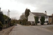
[[File:|thumb|right|500px|Robin Hood / Anthony Parkes, 15 Feb. 2014, Creative Commons, via Geograph.]]
By Henrik Thiil Nielsen, 2018-01-10. Revised by Henrik Thiil Nielsen, 2019-05-31.
'Robin Hood' is the name of a hamlet on Robin Hood Lane, north of Appley Bridge, between Hill House Fold Lane and Sparrow Hill/Hall Lane (A5209).
The earliest reference so far known to IRHB is a 6" O.S. map published in 1849, based on a survey carried out 1845-46 (see Maps below).Template:PnItemQry
Gazetteers
- Dobson, R. B., ed.; Taylor, J., ed. Rymes of Robyn Hood: an Introduction to the English Outlaw (London, 1976), p. 298, s.n. Robin Hood.
Maps
- 25" O.S. map Lancashire LXXXV.5 (1894; surveyed 1892)
- 25" O.S. map Lancashire LXXXV.5 (1908; rev. 1907) (georeferenced)
- 25" O.S. map Lancashire LXXXV.5 (1908; rev. 1907)
- 25" O.S. map Lancashire LXXXV.5 (1928; rev. 1927)
- 6" O.S. map Lancashire LXXXV (1849; surveyed 1845-46)
- 6" O.S. map Lancashire LXXXV.NW (1894; surveyed 1892-93)
- 6" O.S. map Lancashire LXXXV.NW (1909; rev. 1907) (georeferenced)]
- 6" O.S. map Lancashire LXXXV.NW (1909; rev. 1907)
- 6" O.S. map Lancashire LXXXV.NW (1929; rev. 1927)
- 6" O.S. map Lancashire LXXXV.NW (1947; rev. 1938).
Brief mention
- Taylor, Henry. 'The Ancient Crosses of Lancashire: The Hundred of Leyland', Transactions of the Lancashire and Cheshire Antiquarian Society, vol. XVII (1899), pp. 1-31; see p. 17
- Farrer, William, ed.; Brownbill, J., ed. The Victoria History of the County of Lancaster (London, 1906), vol. VI, p. 96.
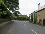
Robin Hood: The junction of Robin Hood Lane with High Moor Lane / David Dixon, 22 Feb. 2016, Creative Commons, via Geograph.
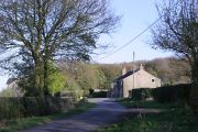
Robin Hood: The end of High Moor Lane / Richard Webb, 2 Jul. 2014, Creative Commons, via Geograph.
Junction of Moss Lane and Robin Hood Lane seen from Hill House Fold Lane / Chris Denny, 26 Apr. 2010, Creative Commons, via Geograph.
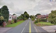
Robin Hood / Google Earth Street View.


