
Robin Hood (Altofts): Difference between revisions
m (Text replacement - "|width=34%}}<div class="pnMapLegend">" to "|width=34%|service=leaflet}}<div class="pnMapLegend">") |
m (Text replacement - "ImgGalleryIntro" to "ImageGalleryIntroduction") |
||
| (23 intermediate revisions by 2 users not shown) | |||
| Line 1: | Line 1: | ||
__NOTOC__{{ | __NOTOC__{{PlaceNamesItemTop|Lat=53.706782|Lon=-1.439100|AdministrativeDivision=Yorkshire|Vicinity=10 Church Road, Altofts, Normanton|Type=Public house|Interest=Robin Hood name|Status=Extant|Demonym=|Riding=West|GreaterLondon=|Year=|Aka=|Century=|Cluster1=|Cluster2=|Cluster3=|Image=Geograph-1405439-by-Betty-Longbottom.jpg|Postcards=|ExtraCat1=|ExtraCat2=|ExtraCat3=|ExtraCat4=|ExtraCat5=|GeopointPrefix=|GeopointSuffix=|StatusSuffix=|DatePrefix=|DateSuffix=}} | ||
{{#display_map:53.7068520,-1.439008|width=34%| | {{#display_map:53.7068520,-1.439008|width=34%|enablefullscreen=yes}}<div class="pnMapLegend">The Robin Hood.</div> | ||
[[File:{{#var:Image}}|thumb|right|500px|The Robin Hood – Church Road / [https://www.geograph.org.uk/photo/1405439 Betty Longbottom, 18 July, 2009, Creative Commons, via Geograph.]]]<div class="no-img"> | |||
<p id="byline">By Henrik Thiil Nielsen, 2013-08-07. Revised by {{#realname:{{REVISIONUSER}}}}, {{REVISIONYEAR}}-{{REVISIONMONTH}}-{{REVISIONDAY2}}.</p> | <p id="byline">By Henrik Thiil Nielsen, 2013-08-07. Revised by {{#realname:{{REVISIONUSER}}}}, {{REVISIONYEAR}}-{{REVISIONMONTH}}-{{REVISIONDAY2}}.</p> | ||
< | The Robin Hood on Church Road in Altofts, not far from Wakefield, has been a locally owned community pub since 2015,<ref>[http://robinhoodaltofts.co.uk.websitebuilder.prositehosting.co.uk/home The Robin Hood – Altofts] (pub's website)</ref> but it is not clear when it was established. It is not included in any of the O.S. maps listed below. | ||
== Gazetteers == | |||
* Not included in {{:Dobson, Richard Barrie 1976a|Dobson & Taylor}}, pp. 293-311. | |||
== Maps == | |||
* [https://maps.nls.uk/view/125644705#zoom=4&lat=8391&lon=1218&layers=BT 25" O.S. map ''Yorkshire'' CCXXXIV.13 (1892; surveyed 1890)] | |||
* [https://maps.nls.uk/geo/explore/#zoom=17&lat=53.7073&lon=-1.4395&layers=168&b=5 25" O.S. map ''Yorkshire'' CCXXXIV.13 (1908; rev. 1905)] (georeferenced) | |||
* [https://maps.nls.uk/view/125644708#zoom=4&lat=9011&lon=1403&layers=BT 25" O.S. map ''Yorkshire'' CCXXXIV.13 (1908; rev. 1905)] | |||
* [https://maps.nls.uk/view/125644711#zoom=5&lat=8611&lon=1208&layers=BT 25" O.S. map ''Yorkshire'' CCXXXIV.13 (1933; rev. 1932)] | |||
* [https://maps.nls.uk/view/102345007#zoom=6&lat=2459&lon=769&layers=BT 6" O.S. map ''Yorkshire'' 234 (1852; surveyed 1846-48)] | |||
* [https://maps.nls.uk/view/100947776#zoom=5&lat=3146&lon=1086&layers=BT 6" O.S. map ''Yorkshire'' CCXXXIV.SW (1894; surveyed 1890)] | |||
* [https://maps.nls.uk/geo/explore/#zoom=17&lat=53.7068&lon=-1.4397&layers=6&b=5 6" O.S. map ''Yorkshire'' CCXXXIV.SW (1908; rev. 1905)] (georeferenced) | |||
* [https://maps.nls.uk/view/100947773#zoom=5&lat=3105&lon=916&layers=BT 6" O.S. map ''Yorkshire'' CCXXXIV.SW (1908; rev. 1905)] | |||
* [https://maps.nls.uk/view/100947770#zoom=5&lat=3262&lon=1011&layers=BT 6" O.S. map ''Yorkshire'' CCXXXIV.SW (1932; rev. 1932)] | |||
* [https://maps.nls.uk/view/100947767#zoom=5&lat=3201&lon=1051&layers=BT 6" O.S. map ''Yorkshire'' CCXXXIV.SW (1944; rev. 1938)] | |||
* [https://maps.nls.uk/view/100947764#zoom=5&lat=3174&lon=1033&layers=BT 6" O.S. map ''Yorkshire'' CCXXXIV.SW (1949; rev. 1948).] | |||
== Background == | |||
* [https://www.facebook.com/robinhoodaltofts/ Facebook: Robin Hood – Altofts] | |||
* [http://robinhoodaltofts.co.uk.websitebuilder.prositehosting.co.uk/ The Robin Hood – Altofts] (pub's website) | |||
* [https://twitter.com/robhoodaltofts?lang=en Twitter: Robin Hood – Altofts.] | |||
== Notes == | |||
<references/> | |||
</div> | |||
<div id="gallery"> | |||
{{ImageGalleryIntroduction}} | |||
<gallery widths="195px"> | |||
File:Geograph-1405439-by-Betty-Longbottom.jpg|The Robin Hood – Church Road / [https://www.geograph.org.uk/photo/1405439 Betty Longbottom, 18 July, 2009, Creative Commons, via Geograph.] | |||
File:geograph-2734928-by-JThomas.jpg|The Robin Hood, Altofts / [https://www.geograph.org.uk/photo/2734928 JThomas, 17 Dec. 2011, Creative Commons, via Geograph.] | |||
File:geograph-451698-by-Bill-Henderson.jpg|The Robin Hood Pub, Altofts / [https://www.geograph.org.uk/photo/451698 Bill Henderson, 1 June 2007, Creative Commons, via Geograph.] | |||
File:robin-hood-altofts-google-earth-street-view.jpg|The Robin Hood, Altofts / Google Earth Street View | |||
</gallery> | |||
</div> | </div> | ||
{{ | {{PlaceNamesItemNavigation}} | ||
Latest revision as of 13:53, 7 January 2021
| Locality | |
|---|---|
| Coordinate | 53.706782, -1.4391 |
| Adm. div. | West Riding of Yorkshire |
| Vicinity | 10 Church Road, Altofts, Normanton |
| Type | Public house |
| Interest | Robin Hood name |
| Status | Extant |
| First Record | |

By Henrik Thiil Nielsen, 2013-08-07. Revised by Henrik Thiil Nielsen, 2021-01-07.
The Robin Hood on Church Road in Altofts, not far from Wakefield, has been a locally owned community pub since 2015,[1] but it is not clear when it was established. It is not included in any of the O.S. maps listed below.
Gazetteers
- Not included in Dobson, R. B., ed.; Taylor, J., ed. Rymes of Robyn Hood: an Introduction to the English Outlaw (London, 1976), pp. 293-311.
Maps
- 25" O.S. map Yorkshire CCXXXIV.13 (1892; surveyed 1890)
- 25" O.S. map Yorkshire CCXXXIV.13 (1908; rev. 1905) (georeferenced)
- 25" O.S. map Yorkshire CCXXXIV.13 (1908; rev. 1905)
- 25" O.S. map Yorkshire CCXXXIV.13 (1933; rev. 1932)
- 6" O.S. map Yorkshire 234 (1852; surveyed 1846-48)
- 6" O.S. map Yorkshire CCXXXIV.SW (1894; surveyed 1890)
- 6" O.S. map Yorkshire CCXXXIV.SW (1908; rev. 1905) (georeferenced)
- 6" O.S. map Yorkshire CCXXXIV.SW (1908; rev. 1905)
- 6" O.S. map Yorkshire CCXXXIV.SW (1932; rev. 1932)
- 6" O.S. map Yorkshire CCXXXIV.SW (1944; rev. 1938)
- 6" O.S. map Yorkshire CCXXXIV.SW (1949; rev. 1948).
Background
- Facebook: Robin Hood – Altofts
- The Robin Hood – Altofts (pub's website)
- Twitter: Robin Hood – Altofts.
Notes
- ↑ The Robin Hood – Altofts (pub's website)
Image gallery
Click any image to display it in the lightbox, where you can navigate between images by clicking in the right or left side of the current image.
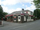
The Robin Hood – Church Road / Betty Longbottom, 18 July, 2009, Creative Commons, via Geograph.
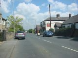
The Robin Hood, Altofts / JThomas, 17 Dec. 2011, Creative Commons, via Geograph.
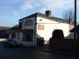
The Robin Hood Pub, Altofts / Bill Henderson, 1 June 2007, Creative Commons, via Geograph.
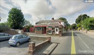
The Robin Hood, Altofts / Google Earth Street View


