
Robin Hood's Well (Helmshore): Difference between revisions
From International Robin Hood Bibliography
m (Text replacement - "{{#ask:[[Category:Records ({{#ifeq:{{#pos:{{PAGENAME}}|(|}}||{{PAGENAME}}|{{#sub:{{PAGENAME}}|0| {{#expr:{{#pos:{{PAGENAME}}|(|}}-1}} }},{{#sub:{{PAGENAME}}|{{#expr:{{#pos:{{PAGENAME}}|(|}}-1}}|1}}{{#sub:{{PAGENAME}}|{{#expr:{{#pos:...) |
m (Text replacement - "{{#ask:[[Category:Records ({{#ifeq:{{#pos:{{PAGENAME}}|(|}}||{{PAGENAME}}|{{#sub:{{PAGENAME}}|0| {{#expr:{{#pos:{{PAGENAME}}|(|}}-1}} }},{{#sub:{{PAGENAME}}|{{#expr:{{#pos:{{PAGENAME}}|(|}}-1}}|1}}{{#sub:{{PAGENAME}}|{{#expr:{{#pos:...) |
||
| Line 8: | Line 8: | ||
The flattened-pyramid-shaped piece of sandstone covering the well has several worn, carved indentations upon it, one of which, near the left-hand side at the front is a wide groove. It is possible that this was made by the wearing down of the stone by a chain securing a drinking cup at its end. However, no trace of any chain or cup can now be discerned.<ref>[http://people.bath.ac.uk/liskmj/living-spring/sourcearchive/ns6/ns6jc1.htm Robin Hood's Well, near Helmshore] by John Crawshaw.</ref></p></div> | The flattened-pyramid-shaped piece of sandstone covering the well has several worn, carved indentations upon it, one of which, near the left-hand side at the front is a wide groove. It is possible that this was made by the wearing down of the stone by a chain securing a drinking cup at its end. However, no trace of any chain or cup can now be discerned.<ref>[http://people.bath.ac.uk/liskmj/living-spring/sourcearchive/ns6/ns6jc1.htm Robin Hood's Well, near Helmshore] by John Crawshaw.</ref></p></div> | ||
The well is indicated on the 1850 6" O.S. map of the area, based on a survey carried out 1844-47. It is found on all subsequent 6" O.S. map of the area avilable at NLS.<ref>See Maps section.</ref> | The well is indicated on the 1850 6" O.S. map of the area, based on a survey carried out 1844-47. It is found on all subsequent 6" O.S. map of the area avilable at NLS.<ref>See Maps section.</ref> | ||
{{ | {{PnItemQry}} | ||
== Gazetteers == | == Gazetteers == | ||
Revision as of 03:05, 17 July 2018
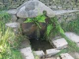
Robin Hood's Well.

Robin Hood's Well / Paul Anderson, 2007, Creative Commons via Geograph.
By Henrik Thiil Nielsen, 2014-10-16. Revised by Henrik Thiil Nielsen, 2018-07-17.
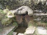
This well is situated on Moor Road about midway between Helmshore and Stubbins. John Crawshaw has recently described it as follows:
The spring issues out from beneath a large, worn stone capping: shaped rather like a flattened pyramid with a blunt apex. This is set against a dry-stone wall by the side of Stake Lane. The water falls from the well-head into a small pool and the whole arrangement of stones has the appearance of great age.
The flattened-pyramid-shaped piece of sandstone covering the well has several worn, carved indentations upon it, one of which, near the left-hand side at the front is a wide groove. It is possible that this was made by the wearing down of the stone by a chain securing a drinking cup at its end. However, no trace of any chain or cup can now be discerned.[1]
The flattened-pyramid-shaped piece of sandstone covering the well has several worn, carved indentations upon it, one of which, near the left-hand side at the front is a wide groove. It is possible that this was made by the wearing down of the stone by a chain securing a drinking cup at its end. However, no trace of any chain or cup can now be discerned.[1]
The well is indicated on the 1850 6" O.S. map of the area, based on a survey carried out 1844-47. It is found on all subsequent 6" O.S. map of the area avilable at NLS.[2] Template:PnItemQry
Gazetteers
- Not included in Dobson, R. B., ed.; Taylor, J., ed. Rymes of Robyn Hood: an Introduction to the English Outlaw (London, 1976), pp. 293-311.
Sources
- Robin Hood's Well, near Helmshore by John Crawshaw.
- Dowsett, Henry. Notes on Holcombe (Manchester, 1901), p. 75.
- Dowsett, Henry. Holcombe long ago (Manchester, 1902). Not seen
Maps
- O.S. 6" map Lancashire Sheet LXXIX (1850, surveyed 1844-47) (at NLS)
- O.S. 6" map Lancashire Sheet LXXIX.NE (1894, surveyed 1891) (at NLS)
- O.S. 6" map Lancashire Sheet LXXIX.NE (1912, surveyed 1908) (at NLS)
- O.S. 6" map Lancashire Sheet LXXIX.NE (1930, surveyed 1927) (at NLS)
- O.S. 6" map Lancashire Sheet LXXIX.NE (1947, surveyed 1938) (at NLS)
Discussion
- The Journal of Antiquities: Robin Hood’s Well, Helmshore, Lancashire; by Ray Spencer.
Brief mention
- Farrer, William, ed.; Brownbill, J., ed. The Victoria History of the County of Lancaster (London, 1906), vol. V, p. 144. Web version at British History Online.
Notes
- ↑ Robin Hood's Well, near Helmshore by John Crawshaw.
- ↑ See Maps section.
Robin Hood's Well / Paul Anderson, 2007, Creative Commons via Geograph.
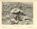
Robin Hood's Well / Panoramio user 'jolmartyn', 2011.
Robin Hood's Well / H. Dowsett's Holcombe long ago (1902) via Ramsbottom Heritage Society.

