Robin Hood's Well (Colwell): Difference between revisions
From International Robin Hood Bibliography
m (Text replacement - "AdmDiv" to "AdministrativeDivision") |
m (Text replacement - "PnItemTop" to "PlaceNamesItemTop") |
||
| Line 1: | Line 1: | ||
__NOTOC__{{ | __NOTOC__{{PlaceNamesItemTop|Lat=55.068966|Lon=-2.073610|AdministrativeDivision=Northumberland|Vicinity=550 m SSE of Colwell, on the east side of B6342|Type=Natural feature|Interest=Robin Hood name|Status=Extant|Demonym=|Riding=|GreaterLondon=|Year=1866|Aka=|Century=|Cluster1=|Cluster2=|Cluster3=|Image=robin-hoods-well-colwell-google-earth.jpg|Postcards=|ExtraCat1=Places named Robin Hood's Well|ExtraCat2=|ExtraCat3=|ExtraCat4=|ExtraCat5=|ExtraLink1=|ExtraLink2=|ExtraLink3=|ExtraLink4=|ExtraLink5=|ExtraLinkName1=|ExtraLinkName2=|ExtraLinkName3=|ExtraLinkName4=|ExtraLinkName5=|GeopointPrefix=|GeopointSuffix=|StatusSuffix=?|DatePrefix=|DateSuffix=}} | ||
{{#display_map:{{#var:Coords}}~{{#replace:{{PAGENAME}}|'|'}}|width=34%|enablefullscreen=yes}}<div class="pnMapLegend">Robin Hood's Well is located a few meters east of the B6342. half a kilometer SSE of Colwell.</div> | {{#display_map:{{#var:Coords}}~{{#replace:{{PAGENAME}}|'|'}}|width=34%|enablefullscreen=yes}}<div class="pnMapLegend">Robin Hood's Well is located a few meters east of the B6342. half a kilometer SSE of Colwell.</div> | ||
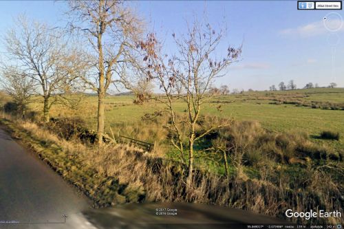
[[File:robin-hoods-well-colwell-google-earth.jpg|thumb|right|500px|Robin Hood's Well is probably located in the area with the tall grass. If not, it must be in the immediate vicinity, assuming it has not run dry / Google Earth Street View.]]<div class="no-img"> | [[File:robin-hoods-well-colwell-google-earth.jpg|thumb|right|500px|Robin Hood's Well is probably located in the area with the tall grass. If not, it must be in the immediate vicinity, assuming it has not run dry / Google Earth Street View.]]<div class="no-img"> | ||
Revision as of 23:56, 5 January 2021
| Locality | |
|---|---|
| Coordinate | 55.068966, -2.07361 |
| Adm. div. | Northumberland |
| Vicinity | 550 m SSE of Colwell, on the east side of B6342 |
| Type | Natural feature |
| Interest | Robin Hood name |
| Status | Extant? |
| First Record | 1866 |
Robin Hood's Well is located a few meters east of the B6342. half a kilometer SSE of Colwell.
By Henrik Thiil Nielsen, 2017-05-08. Revised by Henrik Thiil Nielsen, 2021-01-05.
Very little information is available on Robin Hood's Well, located on the east side of the B6342 about 0.5 km SSE of Colwell, Northumberland. It is included in a list of sites in the vicinity of Swinburn Castle and briefly mentioned on a page with historical information for tourists. That is all. The first reference I have found to it is a 6" OS map of the area published in 1866, based on surveying done in 1862. The well is also indicated and labelled on subsequent versions of the map until at least 1952 (see Maps section below). Template:PnItemQry
Gazetteers
- Not included in Dobson, R. B., ed.; Taylor, J., ed. Rymes of Robyn Hood: an Introduction to the English Outlaw (London, 1976), pp. 293-311.
Maps
- 6" O.S. map Northumberland LXXVII (1866; surveyed 1862)
- 6" O.S. map Northumberland LXXVII.SE (1897; rev. 1895)
- 6" O.S. map Northumberland LXXVII.SE (1897; rev. 1895) (georeferenced)
- 6" O.S. map Northumberland nLXXXII (1925; rev. 1920)
- 6" O.S. map Northumberland nLXXXII (1952; rev. 1946).
Brief mention

