Robin Hood's Walk (Boston): Difference between revisions
From International Robin Hood Bibliography
mNo edit summary |
mNo edit summary |
||
| Line 17: | Line 17: | ||
|data8=[[pnfirstrecord::1640]] | |data8=[[pnfirstrecord::1640]] | ||
}} | }} | ||
{{#display_map:52.985068,-0.025242|width=34%}}<div class="pnMapLegend">Approximate location of Robin Hood's Walk.</div> | |||
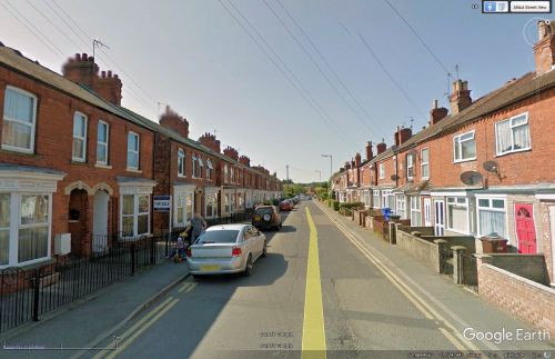
[[File:robin-hoods-walk-boston-google-earth-street-view.jpg|thumb|right|500px|Looking northwest down down Robin Hood's Walk / Google Earth Street View.]] | [[File:robin-hoods-walk-boston-google-earth-street-view.jpg|thumb|right|500px|Looking northwest down down Robin Hood's Walk / Google Earth Street View.]] | ||
<p id="byline">By Henrik Thiil Nielsen, 2013-07-09. Revised by {{#realname:{{REVISIONUSER}}}}, {{REVISIONYEAR}}-{{REVISIONMONTH}}-{{REVISIONDAY2}}.</p><div class="no-img"> | <p id="byline">By Henrik Thiil Nielsen, 2013-07-09. Revised by {{#realname:{{REVISIONUSER}}}}, {{REVISIONYEAR}}-{{REVISIONMONTH}}-{{REVISIONDAY2}}.</p><div class="no-img"> | ||
Described in 1856 as a "narrow winding lane, which was formerly the bed of the Scire-beck" (see 1856 Allusion), Robin Hood's Walk is now a meandering residential street in Boston. First recorded in 1640, this street name has more recently, one assumes, inspired a cluster of Robin Hood-related street names in the immediate vicinity: [[Friar Way (Boston)|Friar Way]], [[Greenwood Drive (Boston)|Greenwood Drive]], [[Locksley Close (Boston)|Locksley Close]], [[Marian Road (Boston)|Marian Road]], [[Sheriff Way (Boston)|Sheriff Way]] and [[Sherwood Avenue (Boston)|Sherwood Avenue.]] | Described in 1856 as a "narrow winding lane, which was formerly the bed of the Scire-beck" (see 1856 Allusion), Robin Hood's Walk is now a meandering residential street in Boston. First recorded in 1640, this street name has more recently, one assumes, inspired a cluster of Robin Hood-related street names in the immediate vicinity: [[Friar Way (Boston)|Friar Way]], [[Greenwood Drive (Boston)|Greenwood Drive]], [[Locksley Close (Boston)|Locksley Close]], [[Marian Road (Boston)|Marian Road]], [[Sheriff Way (Boston)|Sheriff Way]] and [[Sherwood Avenue (Boston)|Sherwood Avenue.]] | ||
Revision as of 08:44, 16 September 2017
| Locality | |
|---|---|
| Coordinates | 52.985068, -0.025242 |
| Adm. div. | Lincolnshire |
| Vicinity | Boston |
| Type | Thoroughfare |
| Interest | Robin Hood name |
| Status | Extant |
| First Record | 1640 |
Approximate location of Robin Hood's Walk.
By Henrik Thiil Nielsen, 2013-07-09. Revised by Henrik Thiil Nielsen, 2017-09-16.
Described in 1856 as a "narrow winding lane, which was formerly the bed of the Scire-beck" (see 1856 Allusion), Robin Hood's Walk is now a meandering residential street in Boston. First recorded in 1640, this street name has more recently, one assumes, inspired a cluster of Robin Hood-related street names in the immediate vicinity: Friar Way, Greenwood Drive, Locksley Close, Marian Road, Sheriff Way and Sherwood Avenue.
Allusions
Gazetteers
- Not included in Dobson, R. B., ed.; Taylor, J., ed. Rymes of Robyn Hood: an Introduction to the English Outlaw (London, 1976), pp. 293-311.
Sources
- Thompson, Pishey. The History and Antiquities of Boston (Boston, England; London; Boston, Massachusetts, 1856), pp. 199-200, 466.
Also see
Notes
"th" can not be assigned to a declared number type with value 17.

