
Robin Hood's Tump (Tilstone Fearnall): Difference between revisions
mNo edit summary |
mNo edit summary |
||
| Line 6: | Line 6: | ||
'Robin Hood's Tump' is the name of the turf- and tree-covered remains of a Bronze Age round or bowl barrow situated on the north and west side of a turn in Vale Road, about 115 metres south of Nantwich Road (A5) in Tilstone Fearnall, Alpraham parish, Cheshire. | 'Robin Hood's Tump' is the name of the turf- and tree-covered remains of a Bronze Age round or bowl barrow situated on the north and west side of a turn in Vale Road, about 115 metres south of Nantwich Road (A5) in Tilstone Fearnall, Alpraham parish, Cheshire. | ||
During excavation carried out by W. J. Varley in the 1930s,<ref>[https://historicengland.org.uk/listing/the-list/list-entry/1011120 Historic England: Robin Hood's Tump bowl barrow.]</ref> no burials were found in the barrow, which was found to be constructed of sand and turf. However, a dozen worked flints were | During excavation carried out by W. J. Varley in the 1930s,<ref>[https://historicengland.org.uk/listing/the-list/list-entry/1011120 Historic England: Robin Hood's Tump bowl barrow.]</ref> no burials were found in the barrow, which was found to be constructed of sand and turf. However, a dozen worked flints were discovered. Two post holes and a pit in the northern perimeter of the mound were attributed to occupation of the site prior to the construction of the mound. The mound is ''c.'' 17 m in diameter, reaching a height of no more than 1.2 m<ref>{{:Varley, W J 1940a}}, p. 48; {{:Congress of Archaeological Societies 1936a}}, see p. 22; neither seen but cf. PastScape above.</ref> | ||
The 'Tump' is included as an unnamed 'Tumulus' in the early 25" O.S. maps listed below. The earliest reference to use the name 'Robin Hood's Tump' may be an article by archaeologist J. W. Jackson published in 1936.<ref>{{:Jackson, J Wilfred 1936a}}, see p. 97; not seen but cf. Historic England under Sources above.</ref> | The 'Tump' is included as an unnamed 'Tumulus' in the early 25" O.S. maps listed below. The earliest reference to use the name 'Robin Hood's Tump' may be an article by archaeologist J. W. Jackson published in 1936.<ref>{{:Jackson, J Wilfred 1936a}}, see p. 97; not seen but cf. Historic England under Sources above.</ref> | ||
Revision as of 21:57, 28 November 2020
[[File:|thumb|right|500px|Robin Hood's Tump, Tilstone Fearnall / Tim Prevett, 26 Nov. 2013; via Megalithic Portal; used by permission.]]
By Henrik Thiil Nielsen, 2020-11-28. Revised by Henrik Thiil Nielsen, 2020-11-28. Photo courtesy Tim Prevett, via the Megalithic Portal. Tim, who produces and acts as consultant and lecturer on slow TV, kindly brought this place-name to IRHB's attention.
'Robin Hood's Tump' is the name of the turf- and tree-covered remains of a Bronze Age round or bowl barrow situated on the north and west side of a turn in Vale Road, about 115 metres south of Nantwich Road (A5) in Tilstone Fearnall, Alpraham parish, Cheshire.
During excavation carried out by W. J. Varley in the 1930s,[1] no burials were found in the barrow, which was found to be constructed of sand and turf. However, a dozen worked flints were discovered. Two post holes and a pit in the northern perimeter of the mound were attributed to occupation of the site prior to the construction of the mound. The mound is c. 17 m in diameter, reaching a height of no more than 1.2 m[2]
The 'Tump' is included as an unnamed 'Tumulus' in the early 25" O.S. maps listed below. The earliest reference to use the name 'Robin Hood's Tump' may be an article by archaeologist J. W. Jackson published in 1936.[3] Template:PnItemQry
Gazetteers
- Not included in Dobson, R. B., ed.; Taylor, J., ed. Rymes of Robyn Hood: an Introduction to the English Outlaw (London, 1976), pp. 293-311.
Sources
- Congress of Archaeological Societies, in union with The Society of Antiquaries of London. Report of the Forty-Third Congress and of the Research Committee for the year 1935, The Antiquaries Journal, vol. XVI (1936), (report enclosed in issue for October 1936), see p. 22; not seen but cf. PastScape above.
- Historic England: Robin Hood's Tump bowl barrow
- Jackson, J. Wilfred. 'The Prehistoric Archaeology of Lancashire and Cheshire', Transactions of the Lancashire and Cheshire Antiquarian Society, vol. L, pp. 65-106, see p. 97; not seen but cf. Historic England ahove.
- Megalithic Portal: Robin Hood's Tump - Round Barrow(s) in England in Cheshire
- PastScape: Robin Hood's Tump
- Varley, W. J., ed.; Jackson, J. W., ed. Prehistoric Cheshire (Handbooks to the History of Cheshire, No. 1) (Chester, 1940), p. 48; not seen but cf. PastScape above.
Maps
- 25" O.S. map Cheshire XLVIII.10 (1875; surveyed 1873)
- 25" O.S. map Cheshire XLVIII.10 (1898; rev. 1897) (georeferenced)
- 25" O.S. map Cheshire XLVIII.10 (1898; rev. 1897)
- 25" O.S. map Cheshire XLVIII.10 (1910; rev. 1908)
- 6" O.S. map Cheshire XLVIII (1881; surveyed 1874)
- 6" O.S. map Cheshire XLVIII.SW (1899; rev. 1897) (georeferenced)
- 6" O.S. map Cheshire XLVIII.SW (1899; rev. 1897)
- 6" O.S. map Cheshire XLVIII.SW (1911; rev. 1908)
- 6" O.S. map Cheshire XLVIII.SW (c. 1935; rev. 1908)
- 6" O.S. map Cheshire XLVIII.SW (c. 1935; rev. 1908)
- 6" O.S. map Cheshire XLVIII.SW (c. 1936; rev. 1908).
Notes
- ↑ Historic England: Robin Hood's Tump bowl barrow.
- ↑ Varley, W. J., ed.; Jackson, J. W., ed. Prehistoric Cheshire (Handbooks to the History of Cheshire, No. 1) (Chester, 1940), p. 48; Congress of Archaeological Societies, in union with The Society of Antiquaries of London. Report of the Forty-Third Congress and of the Research Committee for the year 1935, The Antiquaries Journal, vol. XVI (1936), (report enclosed in issue for October 1936), see p. 22; neither seen but cf. PastScape above.
- ↑ Jackson, J. Wilfred. 'The Prehistoric Archaeology of Lancashire and Cheshire', Transactions of the Lancashire and Cheshire Antiquarian Society, vol. L, pp. 65-106, see p. 97; not seen but cf. Historic England under Sources above.
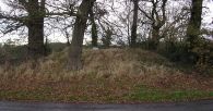
Robin Hood's Tump, Tilstone Fearnall / Tim Prevett, 26 Nov. 2013; via Megalithic Portal; used by permission.
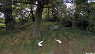
Robin Hood's Tump / Google Earth Street View.

