
Robin Hood's Tump (Tilstone Fearnall): Difference between revisions
From International Robin Hood Bibliography
mNo edit summary |
mNo edit summary |
||
| Line 9: | Line 9: | ||
* Not included in {{:Dobson, Richard Barrie 1976a}}, pp. 293-311. | * Not included in {{:Dobson, Richard Barrie 1976a}}, pp. 293-311. | ||
== Sources == | == Sources == | ||
* | * [https://www.megalithic.co.uk/article.php?sid=5455 Megalithic POrtal: Robin Hood's Tump - Round Barrow(s) in England in Cheshire.] | ||
== Maps == | == Maps == | ||
* [https://maps.nls.uk/view/114584581#zoom=5&lat=4201&lon=6850&layers=BT 25" O.S. map ''Cheshire'' XLVIII.10 (1875; surveyed 1873)] | |||
* [https://maps.nls.uk/geo/explore/#zoom=19&lat=53.13497&lon=-2.63705&layers=168&b=5 25" O.S. map ''Cheshire'' XLVIII.10 (1898; rev. 1897)] (georeferenced) | |||
* [https://maps.nls.uk/view/114584584#zoom=6&lat=4487&lon=7441&layers=BT 25" O.S. map ''Cheshire'' XLVIII.10 (1898; rev. 1897)] | |||
* [https://maps.nls.uk/view/114584587#zoom=5&lat=4749&lon=7004&layers=BT 25" O.S. map ''Cheshire'' XLVIII.10 (1910; rev. 1908)] | |||
* [https://maps.nls.uk/view/102341101#zoom=7&lat=3930&lon=5449&layers=BT 6" O.S. map ''Cheshire'' XLVIII (1881; surveyed 1874)] | |||
* [https://maps.nls.uk/geo/explore/#zoom=17&lat=53.13514&lon=-2.63860&layers=6&b=5 6" O.S. map ''Cheshire'' XLVIII.SW (1899; rev. 1897)] (georeferenced) | |||
* [https://maps.nls.uk/view/101599195#zoom=7&lat=4525&lon=6270&layers=BT 6" O.S. map ''Cheshire'' XLVIII.SW (1899; rev. 1897)] | |||
* [https://maps.nls.uk/view/101599192#zoom=7&lat=4399&lon=6153&layers=BT 6" O.S. map ''Cheshire'' XLVIII.SW (1911; rev. 1908)] | |||
* [https://maps.nls.uk/view/102191539#zoom=7&lat=4620&lon=6029&layers=BT 6" O.S. map ''Cheshire'' XLVIII.SW (''c.'' 1935; rev. 1908)] | |||
* [https://maps.nls.uk/view/102191539#zoom=7&lat=4652&lon=5922&layers=BT 6" O.S. map ''Cheshire'' XLVIII.SW (''c.'' 1935; rev. 1908)] | |||
* [https://maps.nls.uk/view/102191536#zoom=7&lat=4558&lon=5979&layers=BT 6" O.S. map ''Cheshire'' XLVIII.SW (''c.'' 1936; rev. 1908).] | |||
<!--== Discussion == | <!--== Discussion == | ||
* --> | * --> | ||
Revision as of 18:43, 28 November 2020
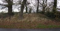
Robin Hood's Tump, Tilstone Fearnall.
[[File:|thumb|right|500px|Robin Hood's Tump, Tilstone Fearnall / Tim Prevett, 26 Nov. 2013; via Megalithic Portal; used by permission.]]
By Henrik Thiil Nielsen, 2020-11-28. Revised by Henrik Thiil Nielsen, 2020-11-28. Photo courtesy Tim Prevett, via the Megalithic Portal. Tim, who produces and acts as consultant and lecturer on slow TV, kindly brought this place-name to IRHB's attention.
Gazetteers
- Not included in Dobson, R. B., ed.; Taylor, J., ed. Rymes of Robyn Hood: an Introduction to the English Outlaw (London, 1976), pp. 293-311.
Sources
Maps
- 25" O.S. map Cheshire XLVIII.10 (1875; surveyed 1873)
- 25" O.S. map Cheshire XLVIII.10 (1898; rev. 1897) (georeferenced)
- 25" O.S. map Cheshire XLVIII.10 (1898; rev. 1897)
- 25" O.S. map Cheshire XLVIII.10 (1910; rev. 1908)
- 6" O.S. map Cheshire XLVIII (1881; surveyed 1874)
- 6" O.S. map Cheshire XLVIII.SW (1899; rev. 1897) (georeferenced)
- 6" O.S. map Cheshire XLVIII.SW (1899; rev. 1897)
- 6" O.S. map Cheshire XLVIII.SW (1911; rev. 1908)
- 6" O.S. map Cheshire XLVIII.SW (c. 1935; rev. 1908)
- 6" O.S. map Cheshire XLVIII.SW (c. 1935; rev. 1908)
- 6" O.S. map Cheshire XLVIII.SW (c. 1936; rev. 1908).
Robin Hood's Tump, Tilstone Fearnall / Tim Prevett, 26 Nov. 2013; via Megalithic Portal; used by permission.
