
Robin Hood's Stone (Allerton, Liverpool) (1): Difference between revisions
m (Text replacement - ".</p><div class="no-img">" to ".</p>") |
m (Text replacement - "<div class="no-img"><p id="byline">" to "<div class="no-img"> <p id="byline">") |
||
| Line 1: | Line 1: | ||
__NOTOC__{{PnItemTop|Lat=53.3715|Lon=-2.9037|AdmDiv=Lancashire|Vicinity=S side of present Greenwood Road, ''c.'' 30 m NE of present Archerfield Road|Type=Monument|Interest=Robin Hood name|Status=Defunct|Demonym=English|Riding=|GreaterLondon=|Year=1850|Aka=|Century=|Cluster1=Allerton|Cluster2=|Cluster3=|Image=robin-hoods-stone-allerton-liverpool-google-earth-street-view-1.jpg|Postcards=|ExtraCat1=Places named Robin Hood's Stone|ExtraCat2=|ExtraCat3=|ExtraCat4=|ExtraCat5=|ExtraLink1=|ExtraLink2=|ExtraLink3=|ExtraLink4=|ExtraLink5=|ExtraLinkName1=|ExtraLinkName2=|ExtraLinkName3=|ExtraLinkName4=|ExtraLinkName5=|GeopointPrefix=|GeopointSuffix=|StatusSuffix=|DatePrefix=|DateSuffix=}} | __NOTOC__{{PnItemTop|Lat=53.3715|Lon=-2.9037|AdmDiv=Lancashire|Vicinity=S side of present Greenwood Road, ''c.'' 30 m NE of present Archerfield Road|Type=Monument|Interest=Robin Hood name|Status=Defunct|Demonym=English|Riding=|GreaterLondon=|Year=1850|Aka=|Century=|Cluster1=Allerton|Cluster2=|Cluster3=|Image=robin-hoods-stone-allerton-liverpool-google-earth-street-view-1.jpg|Postcards=|ExtraCat1=Places named Robin Hood's Stone|ExtraCat2=|ExtraCat3=|ExtraCat4=|ExtraCat5=|ExtraLink1=|ExtraLink2=|ExtraLink3=|ExtraLink4=|ExtraLink5=|ExtraLinkName1=|ExtraLinkName2=|ExtraLinkName3=|ExtraLinkName4=|ExtraLinkName5=|GeopointPrefix=|GeopointSuffix=|StatusSuffix=|DatePrefix=|DateSuffix=}} | ||
{{#display_map:{{#var:Coords}}~{{#replace:{{PAGENAME}}|'|'}}|width=34%|service=leaflet|enablefullscreen=yes}}<div class="pnMapLegend">The original site of Robin Hood's Stone.</div> | {{#display_map:{{#var:Coords}}~{{#replace:{{PAGENAME}}|'|'}}|width=34%|service=leaflet|enablefullscreen=yes}}<div class="pnMapLegend">The original site of Robin Hood's Stone.</div> | ||
[[File:{{#var:Pnimage}}|thumb|right|500px|Here on the south side of the present Greenwood Road, ''c.'' 30 m NE of present Archerfield Road, Robin Hood's Stone stood until August 1928, when it was moved to its present location / Google Earth Street View.]]<div class="no-img"><p id="byline">By Henrik Thiil Nielsen, 2019-02-11. Revised by {{#realname:{{REVISIONUSER}}}}, {{REVISIONYEAR}}-{{REVISIONMONTH}}-{{REVISIONDAY2}}.</p> | [[File:{{#var:Pnimage}}|thumb|right|500px|Here on the south side of the present Greenwood Road, ''c.'' 30 m NE of present Archerfield Road, Robin Hood's Stone stood until August 1928, when it was moved to its present location / Google Earth Street View.]]<div class="no-img"> | ||
<p id="byline">By Henrik Thiil Nielsen, 2019-02-11. Revised by {{#realname:{{REVISIONUSER}}}}, {{REVISIONYEAR}}-{{REVISIONMONTH}}-{{REVISIONDAY2}}.</p> | |||
Robin Hood's Stone in Allerton, Liverpool, now resides on the corner of Booker Avenue and Archerfield Road, but until 1928 its home was at what is now the south side of Greenwood Road, c. 30 m NE of present Archerfield Road. | Robin Hood's Stone in Allerton, Liverpool, now resides on the corner of Booker Avenue and Archerfield Road, but until 1928 its home was at what is now the south side of Greenwood Road, c. 30 m NE of present Archerfield Road. | ||
Revision as of 04:51, 17 May 2020
[[File:|thumb|right|500px|Here on the south side of the present Greenwood Road, c. 30 m NE of present Archerfield Road, Robin Hood's Stone stood until August 1928, when it was moved to its present location / Google Earth Street View.]]
By Henrik Thiil Nielsen, 2019-02-11. Revised by Henrik Thiil Nielsen, 2020-05-17.
Robin Hood's Stone in Allerton, Liverpool, now resides on the corner of Booker Avenue and Archerfield Road, but until 1928 its home was at what is now the south side of Greenwood Road, c. 30 m NE of present Archerfield Road.
The stone is roughly rectangular and approximtely 2 metres high by 90 cm wide by 40 cm thick. On what is now its south-east it has six or seven deep grooves where, according to local legend, Robin Hood and his men sharpened their arrows. Before becoming detached, the stone belonged to the Calderstones complex, a group of neolithic sandstone boulders remaining from a dolmen. At or near its base the stone has cup marks similar to those on the other Calderstones.[1] With development encroaching on its habitat – a field locally known as the Stone Hey, where it stood already by the mid-19th century – the stone was moved to the corner of Booker Avenue and Archerfield Road in August of 1928.[2] When the stone was moved to its present location, a bronze plaque with the following inscription was added:
Gazetteers
- Not included in Dobson, R. B., ed.; Taylor, J., ed. Rymes of Robyn Hood: an Introduction to the English Outlaw (London, 1976), pp. 293-11.
Sources
- Anonymous. 'Report of Local Secretary for Lancaster', Transactions of the Historic Society of Lancashire and Cheshire, vol. LXXX (1928), pp. 224-27; see pp. 226-27: 'Robin Hood's Stone', an interesting account of the removal of the stone to its present location
- Historic England: Robin Hood's Stone at the junction of Archerfield Road and Booker Avenue
- PastScape: Robin Hoods Stone.
Maps
- 25" O.S. map Lancashire CXIII.8 (1893; surveyed 1890)
- 25" O.S. map Lancashire CXIII.8 (1908; rev. 1905) (georeferenced)
- 25" O.S. map Lancashire CXIII.8 (1927; rev. 1924-25)
- 25" O.S. map Lancashire CXIII.8 (1939; rev. 1937).
- 6" O.S. map Lancashire CXIII (1850; surveyed 1846-48)
- 6" O.S. map Lancashire CXIII.NE (1894; surveyed 1889-91)
- 6" O.S. map Lancashire CXIII.NE (1909; rev. 1905) (georeferenced)
- 6" O.S. map Lancashire CXIII.NE (1909; rev. 1905)
- 6" O.S. map Lancashire CXIII.NE (1928; rev. 1924-25)
- 6" O.S. map Lancashire CXIII.NE (c. 1936; rev. 1924-25)
- 6" O.S. map Lancashire CXIII.NE (1946; rev. 1938).
Discussion
- Historic Liverpool: Robin Hood’s Stone
- Journal of Antiquities: Robin Hood’s Stone, Allerton, Liverpool, Merseyside by 'sunbright57'
- The Megalithic Portal: Robin Hood's Stone
- Mike Royden's Local History Pages: The Calderstones.
Background
Notes
- ↑ Wikipedia: Calderstones Park. PastScape: Robin Hoods Stone has 'Bronze Age'. Is this a mistake?
- ↑ PastScape: Robin Hoods Stone; and see 1850 map in list below.
- ↑ Anonymous. 'Report of Local Secretary for Lancaster', Transactions of the Historic Society of Lancashire and Cheshire, vol. LXXX (1928), pp. 224-27; see p. 227.
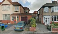
Here on the S side of present Greenwood Road, c. 30 m NE of present Archerfield Road, Robin Hood's Stone stood until 1928, when it was moved to its current location / Google Earth Street View.
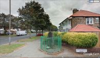
Since 1928 Robin Hood's Stone has stood sentinel on the junction of Booker Avenue and Archerfield Road / Google Earth Street View.
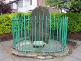
Robin Hood's Stone at its current location / Wikimedia Commons via Journal of Antiquities.
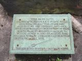
Plaque at Robin Hood's Stone / 'Rept0n1x', 4 Jun. 2012, MediaWiki Commons.


