Robin Hood's Scar (Bowes): Difference between revisions
m (Text replacement - "embedformat=h4" to "embedformat=h3") |
m (Text replacement - "{{#display_map:{{#var:Coords}}~{{#replace:{{PAGENAME}}|'|'}}|width=34%}}<div class="pnMapLegend">" to "{{#display_map:{{#var:Coords}}~{{#replace:{{PAGENAME}}|'|'}}|width=34%|service=leaflet}}<div class="pnMapLegend">") |
||
| Line 1: | Line 1: | ||
__NOTOC__{{PnItemTop|Lat=54.5143|Lon=-1.998|AdmDiv=Yorkshire|Vicinity=700 m ESE of Bowes|Type=Natural feature|Interest=Robin Hood name|Status=Extant|Demonym=|Riding=North|GreaterLondon=|Year=1857|Aka=|Century=|Cluster1=|Cluster2=|Cluster3=|Image=Robin Hoods Scar Bowes Google Earth.jpg|Postcards=|ExtraCat1=Places named Robin Hood's Scar|ExtraCat2=|ExtraCat3=|ExtraCat4=|ExtraCat5=|ExtraLink1=|ExtraLink2=|ExtraLink3=|ExtraLink4=|ExtraLink5=|ExtraLinkName1=|ExtraLinkName2=|ExtraLinkName3=|ExtraLinkName4=|ExtraLinkName5=|GeopointPrefix=|GeopointSuffix=|StatusSuffix=?|DatePrefix=|DateSuffix=}} | __NOTOC__{{PnItemTop|Lat=54.5143|Lon=-1.998|AdmDiv=Yorkshire|Vicinity=700 m ESE of Bowes|Type=Natural feature|Interest=Robin Hood name|Status=Extant|Demonym=|Riding=North|GreaterLondon=|Year=1857|Aka=|Century=|Cluster1=|Cluster2=|Cluster3=|Image=Robin Hoods Scar Bowes Google Earth.jpg|Postcards=|ExtraCat1=Places named Robin Hood's Scar|ExtraCat2=|ExtraCat3=|ExtraCat4=|ExtraCat5=|ExtraLink1=|ExtraLink2=|ExtraLink3=|ExtraLink4=|ExtraLink5=|ExtraLinkName1=|ExtraLinkName2=|ExtraLinkName3=|ExtraLinkName4=|ExtraLinkName5=|GeopointPrefix=|GeopointSuffix=|StatusSuffix=?|DatePrefix=|DateSuffix=}} | ||
{{#display_map:{{#var:Coords}}~{{#replace:{{PAGENAME}}|'|'}}|width=34%}}<div class="pnMapLegend">Robin Hood's Scar.</div> | {{#display_map:{{#var:Coords}}~{{#replace:{{PAGENAME}}|'|'}}|width=34%|service=leaflet}}<div class="pnMapLegend">Robin Hood's Scar.</div> | ||
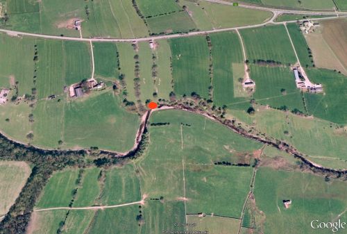
[[File:Robin Hoods Scar Bowes Google Earth.jpg|500px|thumb|right|The red ellipse indicates the location of Robin Hood's Scar on the riverbank / Google Earth Street View. Click image to enlarge.]] | [[File:Robin Hoods Scar Bowes Google Earth.jpg|500px|thumb|right|The red ellipse indicates the location of Robin Hood's Scar on the riverbank / Google Earth Street View. Click image to enlarge.]] | ||
<p id="byline">By Henrik Thiil Nielsen, 2016-05-22. Revised by {{#realname:{{REVISIONUSER}}}}, {{REVISIONYEAR}}-{{REVISIONMONTH}}-{{REVISIONDAY2}}.</p> | <p id="byline">By Henrik Thiil Nielsen, 2016-05-22. Revised by {{#realname:{{REVISIONUSER}}}}, {{REVISIONYEAR}}-{{REVISIONMONTH}}-{{REVISIONDAY2}}.</p> | ||
Revision as of 08:56, 5 April 2019
By Henrik Thiil Nielsen, 2016-05-22. Revised by Henrik Thiil Nielsen, 2019-04-05.
About 700 m ESE of Bowes, by a bend in the Greta, is found Robin Hood's Scar. It is indicated on a 6" O.S. map of the Boldron–Bowes–Lartington–Startforth area published in 1857 as well as on one published in 1895.[1] A Google search in May 2016 yielded only one result, a 1955 doctoral dissertation which briefly discusses geological features of this locality.[2] The fact that this geologist referred to the name Robin Hood's Scar does not necessarily mean that it was still current at the time, for the kind of study he carried out would have led him to consult detailed maps of Yorkshire and he may have learned the name of this locality from an O.S. map. It is therefore uncertain if this place-name was still in use at the time or indeed if it is still current.
Gazetteers
- Not included in Dobson, R. B., ed.; Taylor, J., ed. Rymes of Robyn Hood: an Introduction to the English Outlaw (London, 1976), pp. 293-311.
Maps
- 6" O.S. map Yorkshire 12 (incl. Boldron; Bowes; Lartington; Startforth) (1857, surveyed 1854)
- 6" O.S. map Yorkshire XII.SW (incl. Bowes; Gilmonby) (1895, surveyed 1891-92.)
Brief mention
Notes
- ↑ 6" O.S. map Yorkshire 12 (incl. Boldron; Bowes; Lartington; Startforth); 6" O.S. map Yorkshire XII.SW (incl. Bowes; Gilmonby) (1895, surveyed 1891-92.)
- ↑ Wells, A.J. The Stratigraphy and Structure of the Middleton Tyas-Sleightholme Anticline and the Development of Chert between the Underset and Crow Limestones in North Yorkshire ([Durham]: University of Durham, 1955), pp. 46, 64.

