
Robin Hood's Mill (Stackhouse): Difference between revisions
mNo edit summary |
mNo edit summary |
||
| Line 1: | Line 1: | ||
__NOTOC__{{PnItemTop|Lat=54.0951|Lon=-2.2851|AdmDiv=Yorkshire|Vicinity=''c''. 1 km NNE of Stackhouse, between the Ribble and Stainforth Lane|Type=Natural feature|Interest=Robin Hood name|Status=Defunct|Demonym=|Riding=West|GreaterLondon=|Year=1851|Aka=|Century=|Cluster1=Stainforth|Cluster2=|Cluster3=|Image=Stackhouse place-name cluster.jpg|Postcards=|ExtraCat1=|ExtraCat2=|ExtraCat3=|ExtraCat4=|ExtraCat5=|GeopointPrefix=|GeopointSuffix=|StatusSuffix=?|DatePrefix=|DateSuffix=}} | __NOTOC__{{PnItemTop|Lat=54.0951|Lon=-2.2851|AdmDiv=Yorkshire|Vicinity=''c''. 1 km NNE of Stackhouse, between the Ribble and Stainforth Lane|Type=Natural feature|Interest=Robin Hood name|Status=Defunct|Demonym=|Riding=West|GreaterLondon=|Year=1851|Aka=|Century=|Cluster1=Stainforth|Cluster2=|Cluster3=|Image=Stackhouse place-name cluster.jpg|Postcards=|ExtraCat1=|ExtraCat2=|ExtraCat3=|ExtraCat4=|ExtraCat5=|GeopointPrefix=|GeopointSuffix=|StatusSuffix=?|DatePrefix=|DateSuffix=}} | ||
{{#display_map:{{#var:Coords}}~{{#replace:{{PAGENAME}}|'|'}}|width=34%}}<div class="pnMapLegend">Probable approximate location of Robin Hood's Mill. A less likely alternative location is the neighbouring field immediately west of Stainforth Lane.</div> | {{#display_map:{{#var:Coords}}~{{#replace:{{PAGENAME}}|'|'}}|width=34%}}<div class="pnMapLegend">Probable approximate location of Robin Hood's Mill. A less likely alternative location is the neighbouring field immediately west of Stainforth Lane.</div> | ||
[[File:RHs Mill (Stackhuse).jpg|thumb|right|500px|Robin Hood's Mill was located either | [[File:RHs Mill (Stackhuse).jpg|thumb|right|500px|Robin Hood's Mill was located either under the field where what looks like areas of exposed gravel are visible or, more probably, under the field opposite, on the right side of the road (Stainforth Lane).]] | ||
[[File:Stackhouse place-name cluster.jpg|thumb|right|500px|The red dots indicate Robin Hood's Mill, top left (possible location) or top right (probable location), with [[Robin Hood Close (Giggleswick)|Robin Hood Close]] just below.]] | [[File:Stackhouse place-name cluster.jpg|thumb|right|500px|The red dots indicate Robin Hood's Mill, top left (possible location) or top right (probable location), with [[Robin Hood Close (Giggleswick)|Robin Hood Close]] just below.]] | ||
<p id="byline">By Henrik Thiil Nielsen, 2014-08-27. Revised by {{#realname:{{REVISIONUSER}}}}, {{REVISIONYEAR}}-{{REVISIONMONTH}}-{{REVISIONDAY2}}.</p> | <p id="byline">By Henrik Thiil Nielsen, 2014-08-27. Revised by {{#realname:{{REVISIONUSER}}}}, {{REVISIONYEAR}}-{{REVISIONMONTH}}-{{REVISIONDAY2}}.</p> | ||
Revision as of 15:55, 2 February 2019
.jpg)

By Henrik Thiil Nielsen, 2014-08-27. Revised by Henrik Thiil Nielsen, 2019-02-02.
Allusions
1879 - Thomson, J Radford - Guide to the District of Craven
Robin Hood's Mill is the name given to a spot between Little Stainforth and Stackhouse, where a rumbling noise may be heard below the ground, doubtless caused by a subterranean waterfall, such as are not uncommon in this district.[2]
1937 - Palmer, William T - Odd Corners in Yorkshire Dales
Yorkshire is unique in Britain for underground cascades and waterfalls. In many dales and moors the sheets of mountain limestone are fissured and cracked by past earth-movements, and the rain-water, percolating through the heather, bog, and grass, has dissolved shafts and steps into the depths. At many fissures, even on high moors and ridges, the sound of falling water can be heard, and of course there are jets and fountains in the potholes which require special equipment for their descent. If you lay your ear to the ground at a certain point in Ribblesdale you will hear "how the water comes down at Lodore" in fairyland, although not so much as a rivulet is to be seen outside Robin Hood's Mill. Hellen Pot has an underground waterfall of about 40 feet, and many others could be recorded. Hull Pot, an open fissure near Horton-in-Ribblesdale, also has a fall of 50 feet, part of which is visible. Alum Pot, on the south side of the Ribble, has a water-course entering 50 feet below the surface by way of Long Churn, a side gallery which itself has one or two small water-falls. At the lip there is a rush of water into the black main chamber.[3]
Gazetteers
- Not included in Dobson, R. B., ed.; Taylor, J., ed. Rymes of Robyn Hood: an Introduction to the English Outlaw (London, 1976), pp. 293-311.
Maps
- 6" O.S. map Yorkshire 132 (1851, surveyed 1847) (Robin Hood's Mill indicated).
- 6" O.S. map Yorkshire CXXXII (1896, surveyed 1893-94) (Robin Hood's Mill indicated).
- 6" O.S. map Yorkshire CXXXII.NW (1910, surveyed 1907) (Robin Hood's Mill indicated).
Notes
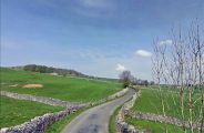
Robin Hood's Mill was located either in the field where what looks like areas of exposed gravel are visible or, more probably, in the field opposite, on the right side of the road (Stainforth Lane).
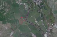
The red dots indicate Robin Hood's Mill, top left (possible location) or top right (probable location), with Robin Hood Close just below.