
Robin Hood's Mill (Stackhouse): Difference between revisions
mNo edit summary |
m (Text replacement - " Category:Yorkshire place-names" to "") |
||
| Line 48: | Line 48: | ||
<div id="dplcatlinks" class="subcategory"><div id="dplcatarea"> | <div id="dplcatlinks" class="subcategory"><div id="dplcatarea"> | ||
{{#ask: [[Category:English place-names]] | {{#ask: [[Category:English place-names]] | ||
[[Category:West Riding of Yorkshire place-names]][[Utitle::<<{{#replace:{{uc:{{PAGENAME}}}}|'|'}}]]|order=descending|searchlabel=|format=template|introtemplate=BeforeNav|template=Nav|outrotemplate=Previous|link=none|limit=1|sort=Utitle}}[[West Riding of Yorkshire place-names]]{{#ask: [[Category:English place-names]] | [[Category:West Riding of Yorkshire place-names]][[Utitle::<<{{#replace:{{uc:{{PAGENAME}}}}|'|'}}]]|order=descending|searchlabel=|format=template|introtemplate=BeforeNav|template=Nav|outrotemplate=Previous|link=none|limit=1|sort=Utitle}}[[West Riding of Yorkshire place-names]]{{#ask: [[Category:English place-names]] | ||
[[Category:West Riding of Yorkshire place-names]][[Utitle::>>{{#replace:{{uc:{{PAGENAME}}}}|'|'}}]]|order=ascending|searchlabel=|format=template|introtemplate=BeforeNav|template=Nav|outrotemplate=Next|link=none|limit=1|sort=Utitle}} | [[Category:West Riding of Yorkshire place-names]][[Utitle::>>{{#replace:{{uc:{{PAGENAME}}}}|'|'}}]]|order=ascending|searchlabel=|format=template|introtemplate=BeforeNav|template=Nav|outrotemplate=Next|link=none|limit=1|sort=Utitle}} | ||
<p>{{#ask: [[Category:English | <p>{{#ask: [[Category:English place-names]][[Utitle::<<{{#replace:{{uc:{{PAGENAME}}}}|'|'}}]]|order=descending|searchlabel=|format=template|introtemplate=BeforeNav|template=Nav|outrotemplate=Previous|link=none|limit=1|sort=Utitle}}[[Yorkshire place-names]]{{#ask: [[Category:English place-names]][[Utitle::>>{{#replace:{{uc:{{PAGENAME}}}}|'|'}}]]|order=ascending|searchlabel=|format=template|introtemplate=BeforeNav|template=Nav|outrotemplate=Next|link=none|limit=1|sort=Utitle}}</p> | ||
{{#ask: [[Category:English place-names]][[Utitle::<<{{#replace:{{uc:{{PAGENAME}}}}|'|'}}]]|order=descending|searchlabel=|format=template|introtemplate=BeforeNav|template=Nav|outrotemplate=Previous|link=none|limit=1|sort=Utitle}}[[Place-names]]{{#ask: [[Category:English place-names]][[Utitle::>>{{#replace:{{uc:{{PAGENAME}}}}|'|'}}]]|order=ascending|searchlabel=|format=template|introtemplate=BeforeNav|template=Nav|outrotemplate=Next|link=none|limit=1|sort=Utitle}}</div></div> | {{#ask: [[Category:English place-names]][[Utitle::<<{{#replace:{{uc:{{PAGENAME}}}}|'|'}}]]|order=descending|searchlabel=|format=template|introtemplate=BeforeNav|template=Nav|outrotemplate=Previous|link=none|limit=1|sort=Utitle}}[[Place-names]]{{#ask: [[Category:English place-names]][[Utitle::>>{{#replace:{{uc:{{PAGENAME}}}}|'|'}}]]|order=ascending|searchlabel=|format=template|introtemplate=BeforeNav|template=Nav|outrotemplate=Next|link=none|limit=1|sort=Utitle}}</div></div> | ||
[[Category:Place-names-topics]] | [[Category:Place-names-topics]] | ||
[[Category:English place-names]] | [[Category:English place-names]] | ||
[[Category:West Riding of Yorkshire place-names]] | [[Category:West Riding of Yorkshire place-names]] | ||
[[Category:Stainforth place-name cluster]] | [[Category:Stainforth place-name cluster]] | ||
Revision as of 15:58, 6 December 2017
| Locality | |
|---|---|
| Coordinates | 54.0951, -2.2851 |
| Adm. div. | West Riding of Yorkshire |
| Vicinity | c. 1 km NNE of Stackhouse, between the Ribble and Stainforth Lane |
| Type | Area |
| Interest | Robin Hood name |
| Status | Extant? |
| First Record | 1851 |
.jpg)

By Henrik Thiil Nielsen, 2014-08-27. Revised by Henrik Thiil Nielsen, 2017-12-06.
Robin Hood's Mill is indicated on an 1851 O.S. 6" map of the Stainforth area[1] (formerly West Riding, now North Yorkshire). The name is included also on later O.S. 6" maps of the area dated 1896 and 1910 (see Maps section below). The mill appears to have been situated in the field between Stainforth Lane to the west and the Ribble to the east, but it is possible it was located in the southeastern corner of the neighbouring field immediately west of Stainforth Lane. Depending on the exact location of the mill, immediately south or southeast of it was Robin Hood Close.
Gazetteers
- Not included in Dobson, R. B., ed.; Taylor, J., ed. Rymes of Robyn Hood: an Introduction to the English Outlaw (London, 1976), pp. 293-311.
Maps
- 6" O.S. map Yorkshire 132 (1851, surveyed 1847) (Robin Hood's Mill indicated).
- 6" O.S. map Yorkshire CXXXII (1896, surveyed 1893-94) (Robin Hood's Mill indicated).
- 6" O.S. map Yorkshire CXXXII.NW (1910, surveyed 1907) (Robin Hood's Mill indicated).
Also see
Notes
- ↑ 6" O.S. Map Yorkshire Sheet 132. (1851, surveyed 1847)
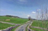
Robin Hood's Mill was located either in the field where what looks like areas of exposed gravel are visible or, more probably, in the field opposite, on the right side of the road (Stainforth Lane).
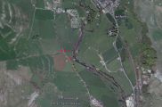
The red dots indicate Robin Hood's Mill, top left (possible location) or top right (probable location), with Robin Hood Close just below.
Template:BeforeNavTemplate:NavTemplate:PreviousWest Riding of Yorkshire place-namesTemplate:BeforeNavTemplate:NavTemplate:Next
Template:BeforeNavTemplate:NavTemplate:PreviousYorkshire place-namesTemplate:BeforeNavTemplate:NavTemplate:Next
Template:BeforeNavTemplate:NavTemplate:PreviousPlace-namesTemplate:BeforeNavTemplate:NavTemplate:Next"th" can not be assigned to a declared number type with value 19.