Robin Hood's Island (Helsington): Difference between revisions
From International Robin Hood Bibliography
m (Text replacement - "{{#ask:[[Category:Records ({{#ifeq:{{#pos:{{PAGENAME}}|(|}}||{{PAGENAME}}|{{#sub:{{PAGENAME}}|0| {{#expr:{{#pos:{{PAGENAME}}|(|}}-1}} }},{{#sub:{{PAGENAME}}|{{#expr:{{#pos:{{PAGENAME}}|(|}}-1}}|1}}{{#sub:{{PAGENAME}}|{{#expr:{{#pos:...) |
m (Text replacement - "{{#ask:[[Category:Records ({{#ifeq:{{#pos:{{PAGENAME}}|(|}}||{{PAGENAME}}|{{#sub:{{PAGENAME}}|0| {{#expr:{{#pos:{{PAGENAME}}|(|}}-1}} }},{{#sub:{{PAGENAME}}|{{#expr:{{#pos:{{PAGENAME}}|(|}}-1}}|1}}{{#sub:{{PAGENAME}}|{{#expr:{{#pos:...) |
||
| Line 7: | Line 7: | ||
Immediately SE of Robin Hood's Island, on the S bank of River Kent is/was located [[Robin Hood's Wood (Helsington)|Robin Hood's Wood]] and 375 m SSW is/was found [[Robin Hood's Well (Helsington)|Robin Hood's Well]]. A small island in a river may have appealed to a youthful imagination. Were these three localities named by children playing in this area? | Immediately SE of Robin Hood's Island, on the S bank of River Kent is/was located [[Robin Hood's Wood (Helsington)|Robin Hood's Wood]] and 375 m SSW is/was found [[Robin Hood's Well (Helsington)|Robin Hood's Well]]. A small island in a river may have appealed to a youthful imagination. Were these three localities named by children playing in this area? | ||
{{ | {{PnItemQry}} | ||
== Gazetteers == | == Gazetteers == | ||
* {{:Dobson, Richard Barrie 1976a}}, p. 305, ''s.n.'' 'Robin Hood Island'.<!-- | * {{:Dobson, Richard Barrie 1976a}}, p. 305, ''s.n.'' 'Robin Hood Island'.<!-- | ||
Revision as of 03:04, 17 July 2018
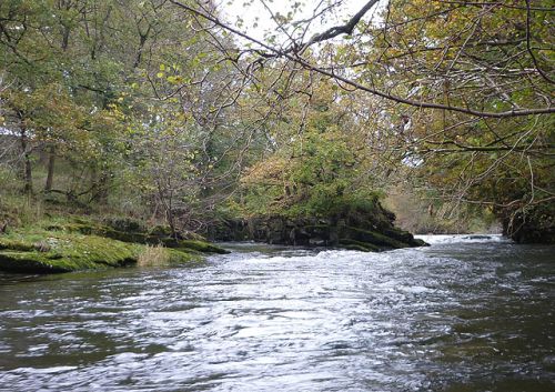
Robin Hood's Island.

Robin Hood's Island, a wooded rock in River Kent, midway between Low Park Wood and Hawes Wood / © Karl and Ali; Creative Commons.
By Henrik Thiil Nielsen, 2016-08-17. Revised by Henrik Thiil Nielsen, 2018-07-17.
Robin Hood's Island (or Robin Hood Island) is a small wooded rock in River Kent at a point approximately equidistant from Helsington, Natland, and Sedgwick, midway between Low Park Wood and Hawes Wood. It is first mentioned in a rental dated 1836.[1]
Immediately SE of Robin Hood's Island, on the S bank of River Kent is/was located Robin Hood's Wood and 375 m SSW is/was found Robin Hood's Well. A small island in a river may have appealed to a youthful imagination. Were these three localities named by children playing in this area? Template:PnItemQry
Gazetteers
- Dobson, R. B., ed.; Taylor, J., ed. Rymes of Robyn Hood: an Introduction to the English Outlaw (London, 1976), p. 305, s.n. 'Robin Hood Island'.
Maps
- 6" O.S. map Lancashire IX (1851-63; surveyed 1847-58)
- 6" O.S. map Westmorland XXXVIII (1863; surveyed 1858)
- 6" O.S. map Westmorland XXXVIII.SE (1899; rev. 1897)
- 6" O.S. map Westmorland XXXVIII.SE (1920; rev. 1911)
- 6" O.S. map Westmorland XXXVIII.SE (1920; rev. 1911)
- 6" O.S. map Westmorland XXXVIII.SE (c. 1947; rev. 1938).
Brief mention
Notes
- ↑ Dobson, R. B., ed.; Taylor, J., ed. Rymes of Robyn Hood: an Introduction to the English Outlaw (London, 1976), p. 305, s.n. 'Robin Hood Island'.
