
Robin Hood's House (Baildon Green): Difference between revisions
m (Text replacement - "PnItemQry" to "PlaceNamesItemQuery") |
m (Text replacement - "PnItemNav" to "PlaceNamesItemNavigation") |
||
| Line 53: | Line 53: | ||
{{ | {{PlaceNamesItemNavigation}} | ||
Revision as of 00:21, 6 January 2021
| Locality | |
|---|---|
| Coordinate | 53.8451, -1.7933 |
| Adm. div. | West Riding of Yorkshire |
| Vicinity | On Baildon Bank, just above Baildon Green |
| Type | Natural feature |
| Interest | Robin Hood name |
| Status | Defunct? |
| First Record | 1838 |

By Henrik Thiil Nielsen, 2020-06-21. Revised by Henrik Thiil Nielsen, 2021-01-06.
A group of large, probably entirely natural, stones on the slope of Baildon Bank, above Baildon Green, was or is known as 'Robin Hood's House'.
There are quite a few stones or areas of exposed rock in the vicnity, and it is by no means certain that the coordinate listed in the infobox and indicated on the interactive map point to the correct piece(s) of rock. However, the suggested coordinate cannot be off by many tens of meters.
An old Yorkshire local historian writing in the early 20th century was convinced that Robin Hood's House was a cromlech. He believed some, but not all, of the stones had 'been placed in position by man' (see 1913 allusion below). A modern writer on Yorkshire traditions observes, in contrast, that there are no clear indications it was a burial chamber, and 'early antiquarians often misinterpreted natural features for artificial ones'.[1]
According to Amelia Edith Huddleston Barr, the writer of the source of the 1912 allusion below, she was six years old when the event she describes took place. Since she was born on March 29 of 1831 or 1832, this would have been at Midsummer of 1837 or 1838. She does not in fact cite the name 'Robin Hood's House', or any other name for that matter, but instead notes that it was averred that the site 'had been one of Robin Hood's retreats'. This is either a local tradition about to crystallize into the folk-name 'Robin Hood's House' or an etiological myth intended to provide an explanation for an already existing name. Let us be kind to Mrs Barr and assume that she did not pick up the name long after the event – IRHB has no evidence that this was the case – and settle on 1838 as the first date of record. It is in any case not very much earlier than the earliest map evidence, a 6" O.S. map of the area published in 1852, based on a survey carried out 1847–48 (see Maps below). The tithe awards for Shipley and Baildon (both from 1849) do not mention Robin Hood's House,[2] Template:PlaceNamesItemQuery
Gazetteers
- Not included in Dobson, R. B., ed.; Taylor, J., ed. Rymes of Robyn Hood: an Introduction to the English Outlaw (London, 1976), pp. 293-311.
- The Northern Antiquarian: Sacred Nature: Rocks, Hills, Lakes.
Maps
- 25" O.S. map Yorkshire CCI.7 (c. 1893; surveyed c. 1890–81). No Copy in NLS
- 25" O.S. map Yorkshire CCI.7 (1908; rev. 1906) (georeferenced)
- 25" O.S. map Yorkshire CCI.7 (1908; rev. 1906)
- 25" O.S. map Yorkshire CCI.7 (1922; rev. 1913)
- 25" O.S. map Yorkshire CCI.7 (1935; rev. 1934)
- 6" O.S. map Yorkshire 201 (1852; surveyed 1847–48)
- 6" O.S. map Yorkshire CCI.NE (1894; surveyed 1889–91)
- 6" O.S. map Yorkshire CCI.NE (1909; rev. 1906) (georeferenced)
- 6" O.S. map Yorkshire CCI.NE (1909; rev. 1906)
- 6" O.S. map Yorkshire CCI.NE (1934; rev. 1934).
Discussion
Background
- 1845 tithe award for Baildon, online at the Genealogist, piece 43, sub-piece 027, Image 413, item 587; Image 426, item 550 (subscription required)
- 1849 tithe award for Shipley, online at the Genealogist, piece 43, sub-piece 352, Images 423-54 (subscription required)
Notes
- ↑ Kai Roberts: Old Elmet Dreaming: Tag Archives: Robin Hood: The Folklore of Shipley Glen & Baildon Moor.
- ↑ MS tithe awards for Shipley and Baildon, online at the Genealogist, piece 43, sub-piece 352, Images 423-54; and piece 43, sub-piece 027, Image 413, item 587; Image 426, item 550 (subscription required).]
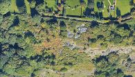
Robin Hood's House would be a little to the right and below centre of this photo / Google Earth Street View.
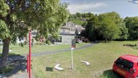
View from Green Road. Robin Hood's House is part of the rocks above the buildings or perhaps situated a little to the right (east) of them / Google Earth Street View.
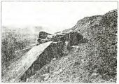
'Robin Hood's House, East View'. Can this very poor scan help identify the rock? / Baildon, W. Paley; Baildon, Francis J. Baildon and the Baildons: a History of a Yorkshire Manor and Family ([s.l.]; Bradford and London, [1912-26]), plate after p. 114.
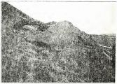
'Robin Hood's House, West View'. Can this very poor scan help identify the rock? / Baildon, W. Paley; Baildon, Francis J. Baildon and the Baildons: a History of a Yorkshire Manor and Family ([s.l.]; Bradford and London, [1912-26]), plate after p. 114.


