
Robin Hood's Hill (Gloucester): Difference between revisions
mNo edit summary |
m (Text replacement - "A.H. Smith" to "A. H. Smith") |
||
| Line 4: | Line 4: | ||
<p id="byline">By Henrik Thiil Nielsen, 2016-08-15. Revised by {{#realname:{{REVISIONUSER}}}}, {{REVISIONYEAR}}-{{REVISIONMONTH}}-{{REVISIONDAY2}}.</p> | <p id="byline">By Henrik Thiil Nielsen, 2016-08-15. Revised by {{#realname:{{REVISIONUSER}}}}, {{REVISIONYEAR}}-{{REVISIONMONTH}}-{{REVISIONDAY2}}.</p> | ||
<div class="no-img"> | <div class="no-img"> | ||
The prominent tree-covered hill in the parish of Matson, ''c.'' 3.3 km SSE of central Gloucester, which used to be known ''inter alia'' as 'Robin Hood's Hill' is now officially named Robin's Wood Hill. It is first mentioned in a 1624 edition of a work by Giraldus Cambrensis, where its name is given as both 'Robinhoodes Hill' and 'Mattesknoll',<ref>{{:Smith, Albert Hugh 1964a}}, pt. II, p. 168.</ref> which latter form is reflected in the (presumably) modern form 'Matson Hill' cited by Dobson & Taylor.<ref>{{:Dobson, Richard Barrie 1976a}}, p. 298, ''s.n.'' 'Robin's Wood Hill'.</ref> In Samuel Rudder's ''History of Gloucestershire'' (1779) the hill is referred to as 'Robin-Hood's hill'.<ref>Smith, ''op. cit.'', pt. II, p. 168, and see ''ibid.'', pt. IV, p. 89.</ref> However, Taylor's map of Gloucestershire, published in 1777, cites the name as 'Robins-wood'.<ref>''Ibid.'', pt. II, p. 168; pt. IV, 86.</ref> According to A.H. Smith, "The name may well recall that of the family of ''Robins'' who had been tenants of the manor [...] and in 1526 obtained a 70-year lease of Matson [...], but ''Robin's Wood'' was by popular etymology changed at an early date to that of ''Robin Hood'' of the ballads."<ref>''Ibid.'', pt. II, p. 168. Smith's italics.</ref> A 'Robins Farm' is located ''c.'' 700 m ENE of the hill (see maps listed in Maps section below). A correspondent to ''Notes & Queries'' noted in 1855 that: | The prominent tree-covered hill in the parish of Matson, ''c.'' 3.3 km SSE of central Gloucester, which used to be known ''inter alia'' as 'Robin Hood's Hill' is now officially named Robin's Wood Hill. It is first mentioned in a 1624 edition of a work by Giraldus Cambrensis, where its name is given as both 'Robinhoodes Hill' and 'Mattesknoll',<ref>{{:Smith, Albert Hugh 1964a}}, pt. II, p. 168.</ref> which latter form is reflected in the (presumably) modern form 'Matson Hill' cited by Dobson & Taylor.<ref>{{:Dobson, Richard Barrie 1976a}}, p. 298, ''s.n.'' 'Robin's Wood Hill'.</ref> In Samuel Rudder's ''History of Gloucestershire'' (1779) the hill is referred to as 'Robin-Hood's hill'.<ref>Smith, ''op. cit.'', pt. II, p. 168, and see ''ibid.'', pt. IV, p. 89.</ref> However, Taylor's map of Gloucestershire, published in 1777, cites the name as 'Robins-wood'.<ref>''Ibid.'', pt. II, p. 168; pt. IV, 86.</ref> According to A. H. Smith, "The name may well recall that of the family of ''Robins'' who had been tenants of the manor [...] and in 1526 obtained a 70-year lease of Matson [...], but ''Robin's Wood'' was by popular etymology changed at an early date to that of ''Robin Hood'' of the ballads."<ref>''Ibid.'', pt. II, p. 168. Smith's italics.</ref> A 'Robins Farm' is located ''c.'' 700 m ENE of the hill (see maps listed in Maps section below). A correspondent to ''Notes & Queries'' noted in 1855 that: | ||
<div class="plainquote">The other outlying hill, Robin's Wood, or Robinhood's, distant about four and a half miles S., singularly analogous in outline to Chosen [a.k.a. Churchdown], is of similar formation, viz. marlstone, though it is capped with a portion of the lower oolite.<ref>{{:Cotteswoldiensis 1855a}}.</ref></div> | <div class="plainquote">The other outlying hill, Robin's Wood, or Robinhood's, distant about four and a half miles S., singularly analogous in outline to Chosen [a.k.a. Churchdown], is of similar formation, viz. marlstone, though it is capped with a portion of the lower oolite.<ref>{{:Cotteswoldiensis 1855a}}.</ref></div> | ||
Revision as of 04:18, 28 April 2020

By Henrik Thiil Nielsen, 2016-08-15. Revised by Henrik Thiil Nielsen, 2020-04-28.
The prominent tree-covered hill in the parish of Matson, c. 3.3 km SSE of central Gloucester, which used to be known inter alia as 'Robin Hood's Hill' is now officially named Robin's Wood Hill. It is first mentioned in a 1624 edition of a work by Giraldus Cambrensis, where its name is given as both 'Robinhoodes Hill' and 'Mattesknoll',[1] which latter form is reflected in the (presumably) modern form 'Matson Hill' cited by Dobson & Taylor.[2] In Samuel Rudder's History of Gloucestershire (1779) the hill is referred to as 'Robin-Hood's hill'.[3] However, Taylor's map of Gloucestershire, published in 1777, cites the name as 'Robins-wood'.[4] According to A. H. Smith, "The name may well recall that of the family of Robins who had been tenants of the manor [...] and in 1526 obtained a 70-year lease of Matson [...], but Robin's Wood was by popular etymology changed at an early date to that of Robin Hood of the ballads."[5] A 'Robins Farm' is located c. 700 m ENE of the hill (see maps listed in Maps section below). A correspondent to Notes & Queries noted in 1855 that:
There is an excellent view of Gloucester from the top of Robin Hood's Hill, a fact soon noted by publishers of photographic postcards, who on the other hand seem to have been less interested in photographing the hill itself. In former times there was a beacon on the top of Robin Hood's Hill. This is indicated on all the 6" O.S. maps available online at NLS (see Maps section below) with the label "Beacon (Site of)". Template:PnItemQry
Gazetteers
- Dobson, R. B., ed.; Taylor, J., ed. Rymes of Robyn Hood: an Introduction to the English Outlaw (London, 1976), p. 298, s.n. 'Robin's Wood Hill'.
Maps
- 6" O.S. map Gloucestershire XXXIII.NE (1884; surveyed 1882-83)
- 6" O.S. map Gloucestershire XXXIII.NE (1903; rev. 1901)
- 6" O.S. map Gloucestershire XXXIII (1903; rev. 1901)
- 6" O.S. map Gloucestershire XXXIII.NE (1924; rev. 1921)
- 6" O.S. map Gloucestershire XXXIII.NE (c. 1946; rev. 1938)
Sources
- Cotteswoldiensis. 'Churchdown', Notes & Queries, Series 1, vol. XII (1855), p. 500
- Smith, A.H., ed. The Place-Names of Gloucestershire (English Place-Name Society, vols. XXXVIII-XLI) (Cambridge, 1964-65), pt. II, p. 168; and for his sources see pt. IV, pp. 84, 86, 89.
Notes
- ↑ Smith, A.H., ed. The Place-Names of Gloucestershire (English Place-Name Society, vols. XXXVIII-XLI) (Cambridge, 1964-65), pt. II, p. 168.
- ↑ Dobson, R. B., ed.; Taylor, J., ed. Rymes of Robyn Hood: an Introduction to the English Outlaw (London, 1976), p. 298, s.n. 'Robin's Wood Hill'.
- ↑ Smith, op. cit., pt. II, p. 168, and see ibid., pt. IV, p. 89.
- ↑ Ibid., pt. II, p. 168; pt. IV, 86.
- ↑ Ibid., pt. II, p. 168. Smith's italics.
- ↑ Cotteswoldiensis. 'Churchdown', Notes & Queries, Series 1, vol. XII (1855), p. 500.
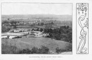
Gloucester, from Robin Hood Hill; early 20th cent. postcard without publisher, place and date / Private collection.
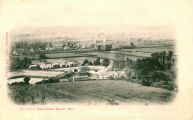
Gloucester from Robin Hood's Hill (Gloucester: Minchin and Gibbs, [s.d.]; early 20th cent. postcard / Private collection.

Gloucester from Robin Hood Hill (W.H.S. and S. County Series); early 20th cent. postcard / Private collection.
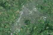
The characteristic circular outline and considerable size of Robin Hood's Hill are seen clearly in this satellite photo / Google Earth Street View.
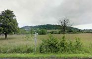
Robin Hood's Hill viewed from the SSE / Google Earth Street View.


