Robin Hood's Grave (Kirklees Priory): Difference between revisions
mNo edit summary |
m (Text replacement - "<div class="pnMapLegend">Approximate location of " to "<div class="pnMapLegend">") |
||
| Line 1: | Line 1: | ||
__NOTOC__{{PnItemTop|Lat=53.689911|Lon=-1.737342|AdmDiv=Yorkshire|Vicinity=Kirklees Priory, Brighouse|Type=Monument|Interest=Robin Hood name|Status=Extant|Demonym=|Riding=West|GreaterLondon=|Year=1500|Aka=|Century=15|Cluster1=Kirklees|Cluster2=Brighouse|Cluster3=|Image=Turner j h 1893 rhs grave.jpg|Postcards=|ExtraCat1=Places named Robin Hood's Grave|ExtraCat2=|ExtraCat3=|ExtraCat4=|ExtraCat5=|GeopointPrefix=|GeopointSuffix=|StatusSuffix=|DatePrefix=''c.'' |DateSuffix= ([[Gest of Robyn Hode|''Gest'']])}} | __NOTOC__{{PnItemTop|Lat=53.689911|Lon=-1.737342|AdmDiv=Yorkshire|Vicinity=Kirklees Priory, Brighouse|Type=Monument|Interest=Robin Hood name|Status=Extant|Demonym=|Riding=West|GreaterLondon=|Year=1500|Aka=|Century=15|Cluster1=Kirklees|Cluster2=Brighouse|Cluster3=|Image=Turner j h 1893 rhs grave.jpg|Postcards=|ExtraCat1=Places named Robin Hood's Grave|ExtraCat2=|ExtraCat3=|ExtraCat4=|ExtraCat5=|GeopointPrefix=|GeopointSuffix=|StatusSuffix=|DatePrefix=''c.'' |DateSuffix= ([[Gest of Robyn Hode|''Gest'']])}} | ||
{{#display_map:{{#var:Coords}}|width=34%}}<div class="pnMapLegend"> | {{#display_map:{{#var:Coords}}|width=34%}}<div class="pnMapLegend">Robin Hood's Grave.</div> | ||
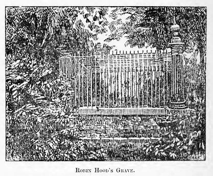
[[File:Turner j h 1893 rhs grave.jpg|thumb|right|500px|Robin Hood's Grave (from: {{:Turner, Joseph Horsfall 1893a}}, p. 202).]] | [[File:Turner j h 1893 rhs grave.jpg|thumb|right|500px|Robin Hood's Grave (from: {{:Turner, Joseph Horsfall 1893a}}, p. 202).]] | ||
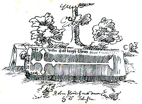
[[File:johnston_nathaniel_robin_hood's_grave_kirklees.jpg|500px|thumb|right|Nathaniel Johnston's drawing of Robin Hood's grave]] | [[File:johnston_nathaniel_robin_hood's_grave_kirklees.jpg|500px|thumb|right|Nathaniel Johnston's drawing of Robin Hood's grave]] | ||
Revision as of 05:08, 25 May 2018

By Henrik Thiil Nielsen, 2013-07-06. Revised by Henrik Thiil Nielsen, 2018-05-25.
Situated in a wooded spot within Kirklees Park, c. 650 m. SW of Kirklees Priory gatehouse, in the grounds of the long gone Kirklees Priory, this is one of the most well known and important localities connected with Robin Hood. As noted under Kirklees Priory, traditions connecting Robin Hood with the priory go back at least to the late 15th century. It is possible that there was originally at Kirklees a grave in which a person named Robert Hood (or similar) was buried. If this was the case, the belief that this was the grave of the famous outlaw may have originated as an etiological myth, a myth of origins[1]. It does not seem anybody was ever buried under the existing monument, but it is likely the original grave was located elsewhere within the priory grounds.
Allusions
Gazetteers
Sources
- Smith, A.H. The Place-Names of the West Riding of Yorkshire (English Place-Name Society, vols. XXX-XXXVII) (Cambridge, 1961-63), pt. III, p. 5, referring to Greenwood's 1771 Map of Yorkshire.
Maps
- Greenwood's 1771 Map of Yorkshire; not seen, but cf. A.H. Smith, loc. cit..
- 6" O.S. map Yorkshire Sheet 246 (1854, surveyed 1848-50) (at NLS).
- 6" O.S. map Yorkshire Sheet CCXLVI.NE (1894, surveyed 1888-92) (at NLS).
- 6" O.S. map Yorkshire Sheet CCXLVI.NE (1908, surveyed 1905) (at NLS).
- 6" O.S. map Yorkshire Sheet CCXLVI.NE (1934, surveyed 1930) (at NLS).
- 6" O.S. map Yorkshire Sheet CCXLVI.NE (1947, surveyed 1938) (at NLS).
- 6" O.S. map Yorkshire Sheet CCXLVI.NE (1949, surveyed 1948) (at NLS).
Discussion
- Crump, W B 1951a.
- Hepworth, David. 'A Grave Tale', in: Phillips, Helen, ed. Robin Hood: Medieval and Post-Medieval (Dublin, 2005), pp. 91-112.
- Hepworth, David, ed. 'Appendix: written epitaphs of Robin Hood', in: Phillips, Helen, ed. Robin Hood: Medieval and Post-Medieval (Dublin, 2005), pp. 188-90.
- Phillips, George Searle. Walks round Huddersfield (Huddersfield, 1848), pp. 29, 46.
- Turner, J. Horsfall. The History of Brighouse, Rastrick, and Hipperholme; with Manorial Notes on Coley, Lightcliffe, Northowram, Shelf, Fixby, Clifton and Kirklees (Bingley, Yorkshire, 1893), pp. 198-205.
Drawings
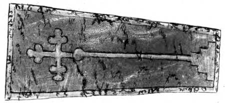
- Nathaniel Johnston's famous drawing of the slab formerly at Robin Hood's Grave is reproduced in most illustrated monographs on the Robin Hood tradition. The original is found in volume 16 of William Stukeley's MS Diary, among his papers in the Bodleian Library.[2]
Background
- Brentnall, Margaret. 'Robin Hood of Sherwood Forest', [Unknown British travel and tourism magazine] (1963-12), pp. 15-17, 58, see p. 58
- Stukeley, William; [W.C. Lukis, ed.] The Family Memoirs of the Rev. William Stukeley (The Publications of the Surtees Society, vols. LXXIII, LXXVI, LXXX) (1882-87), vol. III, p. 500 (item No. 130).
Brief mention
- Anonymous. 'Meetings of Antiquarian Societies', The Antiquary, vol. III (1881), pp. 226-31, see p. 229
- Harris, P. J. 'William of Goldsborough', Notes & Queries, vol. CXCV (1950), p. 150. Asks if there are any other references to the William of Goldsborough mentioned by Grafton.
Notes
- ↑ See Wikipedia: Myth of origins.
- ↑ See Stukeley, William; [W.C. Lukis, ed.] The Family Memoirs of the Rev. William Stukeley (The Publications of the Surtees Society, vols. LXXIII, LXXVI, LXXX) (1882-87), vol. III, p. 500 (item No. 130). For access etc., see Bodleian Library: Collection Level Description: Papers of William Stukeley.


