
Robin Hood's Farm (Tanworth)
From International Robin Hood Bibliography
| Locality | |
|---|---|
| Coordinate | 52.3282, -1.8248 |
| Adm. div. | Warwickshire |
| Vicinity | Danzey Green Lane; c. 900 m SE of Tanworth |
| Type | Building |
| Interest | Robin Hood name |
| Status | Extant |
| First Record | 1830 |
| A.k.a. | Robinhoods Farm |
Robin Hood's Farm from the driveway at Danzey Green Lane.

By Henrik Thiil Nielsen, 2017-01-15. Revised by Henrik Thiil Nielsen, 2022-05-08.
Robin Hood's Farm on Danzey Green Lane, c. 900 m southeast of Tanworth, was in existence by 1830.
The farm is first recorded on an 1830 O.S. map of the area, where it is labelled 'Robinhoods Farm'.[1]
Gazetteers
- Dobson, R. B., ed.; Taylor, J., ed. Rymes of Robyn Hood: an Introduction to the English Outlaw (London, 1976), p. 304, s.n. 'Robinhoods Farm'.
Sources
Maps
- 25" O.S. map Warwickshire XXIV.15 (c. 1888; surveyed c. 1886). No copy in NLS
- 25" O.S. map Warwickshire XXIV.15 (1905; rev. 1903) (georeferenced)
- 25" O.S. map Warwickshire XXIV.15 (1905; rev. 1903)
- 25" O.S. map Warwickshire XXIV.15 (1917; rev. 1914)
- 6" O.S. map Warwickshire XXIV.SE (1886; rev. 1886)
- 6" O.S. map Warwickshire XXIV (1906; rev. 1903) (georeferenced)
- 6" O.S. map Warwickshire XXIV (1921; rev. 1913-14)
- 6" O.S. map Warwickshire XXIV (1921; rev. 1914)
- 6" O.S. map Warwickshire XXIV (c. 1933; rev. 1914).
Photos
Also see
Notes
Image gallery
Click any image to display it in the lightbox, where you can navigate between images by clicking in the right or left side of the current image.
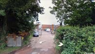
Robin Hood's Farm from the driveway at Danzey Green Lane / Google Earth Street View.
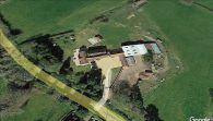
Robin Hood's Farm from the air / Google Earth.
