
Robin Hood's Cave (Walesby): Difference between revisions
m (Text replacement - "PnItemTop" to "PlaceNamesItemTop") |
m (Text replacement - "PnItemQry" to "PlaceNamesItemQuery") |
||
| Line 6: | Line 6: | ||
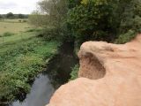
Visitors to the cave describe it as 'not more than a hollow in the Sherwood Sandstone', which is 'approached by a precarious walk along the base of the cliff'<ref>[https://m.geograph.org.uk/photo/1261107 Geograph: SK6670: Almost Robin Hood's Cave.]</ref> or note that '[i]n reality, there is no cave – just a slight overhang of red sandstone'.<ref>[https://m.geograph.org.uk/photo/5975385 Geogreph: SK6670: At Robin Hood's Cave by The River Maun.]</ref> According to one, '[t]he feet of countless visitors have worn away the topsoil' near the outcrop.<ref>[https://m.geograph.org.uk/photo/5926186 Geograph: SK6670: Sandstone outcrop by the River Maun.]</ref> If the locality attracts many sightseers this is no doubt due to several circumstances. There is of course the alleged Robin Hood-connection and the proximity to remnants of Sherwood Forest, and the rock, a remarkable and lovely reddish cream, sits by the river in a wooded area, with the [[Robin Hood Way (Nottinghamshire)|Robin Hood Way]] running past it on the east side. | Visitors to the cave describe it as 'not more than a hollow in the Sherwood Sandstone', which is 'approached by a precarious walk along the base of the cliff'<ref>[https://m.geograph.org.uk/photo/1261107 Geograph: SK6670: Almost Robin Hood's Cave.]</ref> or note that '[i]n reality, there is no cave – just a slight overhang of red sandstone'.<ref>[https://m.geograph.org.uk/photo/5975385 Geogreph: SK6670: At Robin Hood's Cave by The River Maun.]</ref> According to one, '[t]he feet of countless visitors have worn away the topsoil' near the outcrop.<ref>[https://m.geograph.org.uk/photo/5926186 Geograph: SK6670: Sandstone outcrop by the River Maun.]</ref> If the locality attracts many sightseers this is no doubt due to several circumstances. There is of course the alleged Robin Hood-connection and the proximity to remnants of Sherwood Forest, and the rock, a remarkable and lovely reddish cream, sits by the river in a wooded area, with the [[Robin Hood Way (Nottinghamshire)|Robin Hood Way]] running past it on the east side. | ||
{{ | {{PlaceNamesItemQuery}} | ||
== Gazetteers == | == Gazetteers == | ||
* {{:Dobson, Richard Barrie 1976a}}, p. 302, ''s.n.'' Robin Hood's Cave [2]. | * {{:Dobson, Richard Barrie 1976a}}, p. 302, ''s.n.'' Robin Hood's Cave [2]. | ||
Revision as of 00:11, 6 January 2021
| Locality | |
|---|---|
| Coordinate | 53.22997, -1.004901 |
| Adm. div. | Nottinghamshire |
| Vicinity | E bank of River Maun, c. 550 m N of Whitewater Lane, Walesby |
| Type | Natural feature |
| Interest | Robin Hood name |
| Status | Extant |
| First Record | 1825 |

By Henrik Thiil Nielsen, 2020-10-02. Revised by Henrik Thiil Nielsen, 2021-01-06.
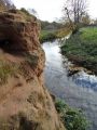
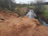
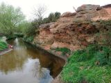
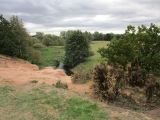
Robin Hood's Cave on the east bank of Whitewater – the local name for River Maun – is located about half a kilometre north of Whitewater Lane. The name 'Robin Hood's Cave' is first recorded in an early O.S. map published in 1825.[1]
Visitors to the cave describe it as 'not more than a hollow in the Sherwood Sandstone', which is 'approached by a precarious walk along the base of the cliff'[2] or note that '[i]n reality, there is no cave – just a slight overhang of red sandstone'.[3] According to one, '[t]he feet of countless visitors have worn away the topsoil' near the outcrop.[4] If the locality attracts many sightseers this is no doubt due to several circumstances. There is of course the alleged Robin Hood-connection and the proximity to remnants of Sherwood Forest, and the rock, a remarkable and lovely reddish cream, sits by the river in a wooded area, with the Robin Hood Way running past it on the east side. Template:PlaceNamesItemQuery
Gazetteers
- Dobson, R. B., ed.; Taylor, J., ed. Rymes of Robyn Hood: an Introduction to the English Outlaw (London, 1976), p. 302, s.n. Robin Hood's Cave [2].
Sources
Maps
- 25" O.S. map Nottinghamshire XIX.6 (1885; surveyed 1884)
- 25" O.s. map Nottinghamshire XIX.6 (c. 1899; rev. c. 1897-98). No Copy in NLS
- 25" O.S. map Nottinghamshire XIX.6 (1920; rev. 1915) (georeferenced)
- 25" O.S. map Nottinghamshire XIX.6 (1920; rev. 1915)
- 6" O.S. map Nottinghamshire XIX.NW (1900; rev. 1897–98) (georeferenced)
- 6" O.S. map Nottinghamshire XIX.NW (1884; surveyed 1883–84)
- 6" O.S. map Nottinghamshire XIX.NW (1900; rev. 1897–98)
- 6" O.S. map Nottinghamshire XIX.NW (1921; rev. 1915)
- 6" O.S. map Nottinghamshire XIX.NW (1900; rev. 1897–98) (georeferenced).
Background
Notes
- ↑ Gover, J.E.B.; Mawer, Allen; Stenton, F.M. The Place-Names of Nottinghamshire (English Place-Name Society, vol. XVII) (Cambridge, 1940), p. 64.
- ↑ Geograph: SK6670: Almost Robin Hood's Cave.
- ↑ Geogreph: SK6670: At Robin Hood's Cave by The River Maun.
- ↑ Geograph: SK6670: Sandstone outcrop by the River Maun.
At Robin Hood's Cave by the River Maun / Neil Theasby, 13 Nov. 2018, Creative Commons, via Geograph.
Above Robin Hood's Cave / Stephen Ostler, 25 Jan. 2020, Creative Commons, via Geograph.
Robin Hood's Cave is located opposite the red can / Tim Heaton, 19 Apr. 2009, Creative Commons, via Geograph.
Sandstone outcrop by the River Maun, beneath lies Robin Hood's Cave / Jonathan Thacker, 1 Oct. 2018, Creative Commons, via Geograph.
Sandstone outcrop by the River Maun, the colour of the exposed rock is rather startling / Jonathan Thacker, 1 Oct. 2018, Creative Commons, via Geograph.


