
Robin Hood's Cave (Outseats): Difference between revisions
mNo edit summary |
mNo edit summary |
||
| Line 1: | Line 1: | ||
__NOTOC__{{PnItemTop|Lat=53.34879|Lon=-1.63460|AdmDiv=Derbyshire|Vicinity=''c.'' 2.5 km NE of Hathersage|Type=Natural feature|Interest=Robin Hood name| | __NOTOC__{{PnItemTop|Lat=53.34879|Lon=-1.63460|AdmDiv=Derbyshire|Vicinity=''c.'' 2.5 km NE of Hathersage|Type=Natural feature|Interest=Robin Hood name| | ||
Status=Extant|Demonym=|Riding=|GreaterLondon=|Year=1880|Aka=|Century=|Cluster1=Hathersage|Cluster2=|Cluster3=|Image=geograph-195297-by-Stephen-Horncastle.jpg|Postcards=|ExtraCat1=Places named Robin Hood's Cave|ExtraCat2=|ExtraCat3=|ExtraCat4=|ExtraCat5=|ExtraLink1=|ExtraLink2=|ExtraLink3=|ExtraLink4=|ExtraLink5=|ExtraLinkName1=|ExtraLinkName2=|ExtraLinkName3=|ExtraLinkName4=|ExtraLinkName5=|GeopointPrefix=|GeopointSuffix=|VicinitySuffix=|StatusSuffix=|DatePrefix=|DateSuffix=}} | Status=Extant|Demonym=|Riding=|GreaterLondon=|Year=1880|Aka=Robin Hoods Cave|Century=|Cluster1=Hathersage|Cluster2=|Cluster3=|Image=geograph-195297-by-Stephen-Horncastle.jpg|Postcards=|ExtraCat1=Places named Robin Hood's Cave|ExtraCat2=|ExtraCat3=|ExtraCat4=|ExtraCat5=|ExtraLink1=|ExtraLink2=|ExtraLink3=|ExtraLink4=|ExtraLink5=|ExtraLinkName1=|ExtraLinkName2=|ExtraLinkName3=|ExtraLinkName4=|ExtraLinkName5=|GeopointPrefix=|GeopointSuffix=|VicinitySuffix=|StatusSuffix=|DatePrefix=|DateSuffix=}} | ||
{{#display_map:{{#var:Coords}}~{{#replace:{{PAGENAME}}|'|'}}|width=34%}}<div class="pnMapLegend">Robin Hood's Cave, Outseats.</div> | {{#display_map:{{#var:Coords}}~{{#replace:{{PAGENAME}}|'|'}}|width=34%}}<div class="pnMapLegend">Robin Hood's Cave, Outseats.</div> | ||
[[File:{{#var:Pnimage}}|thumb|right|500px|Robin Hood's Cave, Outseats / [https://m.geograph.org.uk/photo/195297 Stephen Horncastle, 1 Sep. 2006, Creative Commons, via Geograph.]]] | [[File:{{#var:Pnimage}}|thumb|right|500px|Robin Hood's Cave, Outseats / [https://m.geograph.org.uk/photo/195297 Stephen Horncastle, 1 Sep. 2006, Creative Commons, via Geograph.]]] | ||
Revision as of 20:58, 29 November 2020
[[File:|thumb|right|500px|Robin Hood's Cave, Outseats / Stephen Horncastle, 1 Sep. 2006, Creative Commons, via Geograph.]]
By Henrik Thiil Nielsen, 2020-11-29. Revised by Henrik Thiil Nielsen, 2020-11-29.
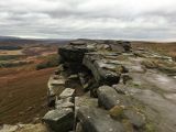
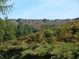
Robin Hood's Cave is situated in Stanage Edge, c. 2.5 km north-east of Hathersage. It is nowadays much frequented by rock climbers and cave enthusiasts.
The earliest reference to this place-name known to IRHB occus in a 25" O.S. map of the area published in 1880, based on a survey carried out in 1879 (see Maps below). Template:PnItemQry
Gazetteers
- Dobson, R. B., ed.; Taylor, J., ed. Rymes of Robyn Hood: an Introduction to the English Outlaw (London, 1976), p. 296 s.n. Robin Hood's Cave
- Megalithic Portal: Robin Hood's Cave - Cave or Rock Shelter in England in Derbyshire.
Maps
- 25" O.S. map Derbyshire X.8 (1880; surveyed 1879)
- 25" O.S. map Derbyshire X.8 (1898; rev. 1896) (georeferenced)
- 25" O.S. map Derbyshire X.8 (1898; rev. 1896)
- 25" O.S. map Derbyshire X.8 (1922; rev. 1919)
- 6" O.S. map Derbyshire X.NE (1883; surveyed 1880)
- 6" O.S. map Yorkshire CCXCIII.SE (1894; surveyed 1891)
- 6" O.S. map Derbyshire X.NE (1899; rev. 1896–97)
- 6" O.S. map Yorkshire CCXCIII.SW. SE & CCXCVIIIA.NE (1905; rev. 1901) (georeferenced)
- 6" O.S. map Yorkshire CCXCIII.SW & SE & CCXCVIIIA.NE (1905; rev. 1901)
- 6" O.S. map Derbyshire X (1923; rev. 1919)
- 6" O.S. map Derbyshire X.NE (1923; rev. 1919)
- 6" O.S. map Yorkshire CCXCIII.SW & SE & CCXCVIIIA.NE (c. 1940; rev. 1920)
- 6" O.S. map Derbyshire X.NE (c. 1945; rev. 1919)
- 6" O.S. map Derbyshire X.NE (c. 1950; rev. 1948)
- 6" O.S. map Yorkshire CCXCIII.SW & SE & CCXCVIIIA.NE (c. 1950; rev. 1948)
- 6" O.S. map Yorkshire CCXCIII.SW & CCXCIII.SE (c. 1954; rev. 1948)
- 1" O.S. map Sheet 99: Chapel en le Frith (Hills) (Rev. New Ser.) (1896)
- 1" O.S. map Sheet 99: Chapel en le Frith (Outline) (Rev. New Ser.) (1896).
Videos
- YouTube: Bertie Visits... Stanage Edge and Robin Hood's Cave (Pipes Hikes)
- YouTube: Stanage Edge and Robin Hood's Cave (Backpacks and Bruises)
- YouTube: Entering Robin Hood's Cave, Stanage Edge (Peak Rambler)
- YouTube: Leaving Robin Hood's Cave, Stanage Edge (Peak Rambler)
- YouTube: Stanage Edge – The Peak District – Millstones and near Robin Hood's Cave (Gaziano Outdoors)
- YouTube: Night in Robin Hood's Cave (Michael Noon)
- YouTube: Robin Hood's Cave (Stanage Edge) – Peak District Adventure (Ben Marks).
Background
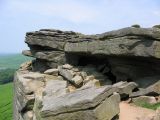
Robin Hood's Cave, Outseats / Stephen Horncastle, 1 Sep. 2006, Creative Commons, via Geograph.
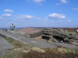
Stanage Edge near Robin Hood's Cave / David Martin, 16 Feb. 2016, Creative Commons, via Geograph.
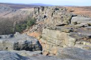
Robin Hood's Cave, Stanage Edge, looking NNW along the edge / John Fielding, 31 Aug. 2010, Creative Commons, via Geograph.
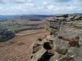
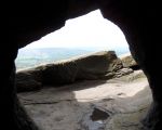
Robin Hood's Cave on Stanage Edge / Steve Fareham, 22 Mar. 2008, Creative Commons, via Geograph.
Rocks above Robin Hood's Cave / Chris Holifield, 13 Oct. 2018, Creative Commons, via Geograph.
Robin Hood's Cave, Stanage Edge / Stephen Horncastle, 7 Apr. 2007, Creative Commons, via Geograph.
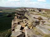
Robin Hood's Cave, Outseats / Brian Deegan, 18 Feb. 2018, Creative Commons, via Geograph.
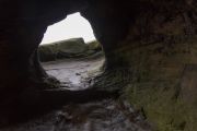
Entrance of Robin Hood's Cave, Stanage Edge / Neil Theasby, 19 May 2013, Creative Commons, via Geograph.
Stanage Edge, viewed from the road leading to North Lees Hall / 'J147', 21 July 2007, Creative Commons, via Geograph.


