
Robin Hood's Butts (Canon Pyon) (1)
[[File:|thumb|right|500px|Pyon Hill, the easternmost of the Robin Hood's Butts in Canon Pyon / Philip Pankhurst, 4 Jul. 2011, Creative Commons.]]
By Henrik Thiil Nielsen, 2018-02-12. Revised by Henrik Thiil Nielsen, 2018-02-13.
'Robin Hood's Butts' is an alternative name of the Pyons, two conically shaped natural hills[1] in Canon Pyon, Herefordshire. The name is first recorded in 1802.
Pyon Hill, the larger and easternmost of the two hills, is located c. 150 m west of the A4110, while Butthouse Knap, its smaller cousin, is located c. 300 m WSW of it. They are situated c. 4.75 and c. 3.6 km southeast of Weobley. George Lipscomb in his Journey into South Wales (1802 Allusion below) notes that "Robin Hood's Butts, a little detached eminence, stands in the midst of a beautiful plain, called Pembridge bottom". I have found no other Robin Hood's Butts in Herefordshire to which this could refer, and in view of the other localities mentioned in the passage he most likely meant the Pyons in Cannon Pyon.
Gazetteers
- Dobson, R. B., ed.; Taylor, J., ed. Rymes of Robyn Hood: an Introduction to the English Outlaw (London, 1976), p. 298, s.n. Robin Hoods' Butts.
Sources
- Crawford, O. G. S. 'Place-Names and Archaeology', chapter VIII in: Mawer, A.; Stenton, F.M. Introduction to the Survey of English Place-Names (English Place-Name Society, vol. I, pt. 1). (Cambridge, 1924), pp. 143-64; see p. 159
- Smith, A.H. English Place-Name Elements. Reprinted (English Place-Name Society, vols. XXV-XXVI) (Cambridge, 1970), pt. I, p. 165 s.n. butt2, b.
Maps
- 25" O.S. map Herefordshre XXVI.1 (1887; rev. 1886)
- 25" O.S. map Herefordshre XXVI.5 (1904; rev. 1902)
- 25" O.S. map Herefordshre XXVI.5 (1904; rev. 1902) (georeferenced)
- 6" O.S. map Herefordshire XXVI.NW 1886; surveyed 1886)
- 6" O.S. map Herefordshire XXVI.NW (1905; rev. 1902)
- 6" O.S. map Herefordshire XXVI.NW (1905; rev. 1902) (georeferenced)
- 6" O.S. map Herefordshire XXVI.NW (1952; rev. 1945)
- 1" O.S. map Hereford (Hills), Sheet 128 (1898; rev. 1897) (georeferenced)
- 1" O.S. map Hereford (Outline), Sheet 128 (1898; rev. 1897) (georeferenced)
- O.S. 1:25,000 SO44 (1956; surveyed 1945) (georeferenced)
- O.S. 1" Hereford (7th Ser.) (1960; surveyed 1944-60) (georeferenced)
- 1:1 million-1:10K O.S. SO 454495 (1900s) (georeferenced)
- 1:1m to 1:63K (1920s–1940s) SO439490 (georeferenced)
- Bartholomew 1/2" Hereford Sheet 23 (1902) (georeferenced)
- Bartholomew 1/2" Wye Valley Sheet 13 (1944) (georeferenced).
Discussion
- BBC: Domesday Reloaded: D-block GB-344000-249000: 1986, Folk Lore,Canon Pyon Area
- Leather, Ella Mary. 'Folk-Lore of the Shire', in: Reade, Compton, ed. Memorials of Old Herefordshire (London and Derby, 1904), pp. 148-66; see p. 163
- Leather, Ella Mary. The Folk-Lore of Herefordshire, collected from Oral and Printed Sources (Hereford; London, 1912), p. ?
- [Nicholson, George, ed.]. The Cambrian Traveller's Guide, in Every Direction; containing Remarks made during Many Excursions, in the Principality of Wales, and Bordering Districts, augmented by Extracts from the Best Writers. Second edition, corrected and considerably enlarged (Stourport and London, 1813), col. 1116. A slightly expanded paraphrase of the 1802 Allusion cited above
- Symonds, W.S. 'The Old Red Sandstone of Herefordshire', in: Moore, H. Cecil, compil. Transactions of the Woolhope Naturalists' Field Club. (Established 1851), 1852 to 1865 (Hereford, 1907), pp. 114-19; see p. 115
- Watkins, Alfred. The Old Straight Track: its Mounds, Beacons, Moats, Sites, and Mark Stones. 4th ed. (London, 1948), pp. 171, 178 (also editions of 1925, 1933, 1946, 1970, 1974, 1975, 1977, and 2014).
Background
Notes
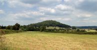
Pyon Hill, the easternmost of the Robin Hood's Butts in Canon Pyon / Philip Pankhurst, 4 Jul. 2011, Creative Commons.
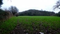
Pyon Hill / Jonathan Billinger, 8 Jan. 2016

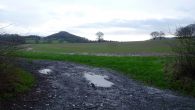
Pyon Hill / Adam Buckley, 7 Aug. 2005
Pyon Hill / Jonathan Billinger, 8 Jan. 2016
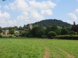
Pyon Hill / Richard Webb, 1 Jul. 2014
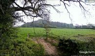
Pyon Hill / Google Earth Street View.


