
Robin Hood's Butts (Canon Pyon) (1): Difference between revisions
From International Robin Hood Bibliography
mNo edit summary |
mNo edit summary |
||
| Line 49: | Line 49: | ||
=== Background === | === Background === | ||
* [https://en.wikipedia.org/wiki/Canon_Pyon Wikipedia: Canon Pyon.] | * [https://en.wikipedia.org/wiki/Canon_Pyon Wikipedia: Canon Pyon.] | ||
{{PnItemAlsoSee}} | {{PnItemAlsoSee}} | ||
Revision as of 17:32, 12 February 2018
Pyon Hill, the easternmost of the Robin Hood's Butts in Pyon Canon.
[[File:|thumb|right|500px|Pyon Hill, the easternmost of the Robin Hood's Butts in Canon Pyon / Philip Pankhurst, 4 Jul. 2011, Creative Commons.]]
By Henrik Thiil Nielsen, 2018-02-12. Revised by Henrik Thiil Nielsen, 2018-02-12.
'Robin Hood's Butts' is the collective name of Pyon Hill and Butthouse Knap, two natural hills[1] in Canon Pyon, Herefordshire. This place-name is first recorded in 1802.
Gazetteers
- Dobson, R. B., ed.; Taylor, J., ed. Rymes of Robyn Hood: an Introduction to the English Outlaw (London, 1976), p. 298, s.n. Robin Hoods' Butts.
Sources
- Crawford, O. G. S. 'Place-Names and Archaeology', chapter VIII in: Mawer, A.; Stenton, F.M. Introduction to the Survey of English Place-Names (English Place-Name Society, vol. I, pt. 1). (Cambridge, 1924), pp. 143-64; see p. 159
- Smith, A.H. English Place-Name Elements. Reprinted (English Place-Name Society, vols. XXV-XXVI) (Cambridge, 1970), pt. I, p. 165 s.n. butt2, b.
Maps
- 25" O.S. map Herefordshre XXVI.1 (1887; rev. 1886)
- 25" O.S. map Herefordshre XXVI.5 (1904; rev. 1902)
- 25" O.S. map Herefordshre XXVI.5 (1904; rev. 1902) (georeferenced)
- 6" O.S. map Herefordshire XXVI.NW 1886; surveyed 1886)
- 6" O.S. map Herefordshire XXVI.NW (1905; rev. 1902)
- 6" O.S. map Herefordshire XXVI.NW (1905; rev. 1902) (georeferenced)
- 6" O.S. map Herefordshire XXVI.NW (1952; rev. 1945)
- 1" O.S. map Hereford (Hills), Sheet 128 (1898; rev. 1897) (georeferenced)
- 1" O.S. map Hereford (Outline), Sheet 128 (1898; rev. 1897) (georeferenced)
- O.S. 1:25,000 SO44 (1956; surveyed 1945) (georeferenced)
- O.S. 1" Hereford (7th Ser.) (1960; surveyed 1944-60) (georeferenced)
- 1:1 million-1:10K O.S. SO 454495 (1900s) (georeferenced)
- 1:1m to 1:63K (1920s–1940s) SO439490 (georeferenced)
- Bartholomew 1/2" Hereford Sheet 23 (1902) (georeferenced)
- Bartholomew 1/2" Wye Valley Sheet 13 (1944) (georeferenced)
Discussion
- Leather, Ella Mary. 'Folk-Lore of the Shire', in: Reade, Compton, ed. Memorials of Old Herefordshire (London and Derby, 1904), pp. 148-66; see p. 163
- Leather, Ella Mary. The Folk-Lore of Herefordshire, collected from Oral and Printed Sources (Hereford; London, 1912), p. ?
- Watkins, Alfred. The Old Straight Track: its Mounds, Beacons, Moats, Sites, and Mark Stones. 4th ed. (London, 1948), pp. 171, 178 (also editions of 1925, 1933, 1946, 1970, 1974, 1975, 1977, and 2014).
Background
Notes
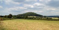
Pyon Hill, the easternmost of the Robin Hood's Butts in Canon Pyon / Philip Pankhurst, 4 Jul. 2011, Creative Commons.
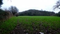
Pyon Hill / Jonathan Billinger, 8 Jan. 2016

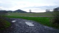
Pyon Hill / Adam Buckley, 7 Aug. 2005
Pyon Hill / Jonathan Billinger, 8 Jan. 2016
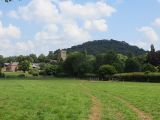
Pyon Hill / Richard Webb, 1 Jul. 2014
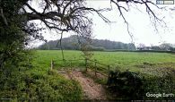
Pyon Hill / Google Earth Street View.


