
Robin Hood's Bow Stones (Lyme Handley): Difference between revisions
m (Text replacement - "<div class="no-img"><p id="byline">" to "<div class="no-img"> <p id="byline">") |
mNo edit summary |
||
| Line 1: | Line 1: | ||
__NOTOC__{{PnItemTop|Lat=53.328705|Lon=-2.040645|AdmDiv=Cheshire|Vicinity=Park Moor; ''c.'' 850 m SE of Lyme Handley|Type=Monument|Interest=Robin Hood name|Status=Defunct|Demonym=English|Riding=|GreaterLondon=|Year=1810|Aka=Robin Hood's Stones; Robin Hood's Picking Stones; Bowstones; Bow Stones|Century=|Cluster1=High Peak|Cluster2=|Cluster3=|Image=robin-hoods-bow-stones-lyme-handley.jpg|Postcards=|ExtraCat1=Places named Robin Hood's Stone|ExtraCat2=Places connected by bowshot|ExtraCat3=|ExtraCat4=|ExtraCat5=|ExtraLink1=Robin Hood's Picking Rods (Chisworth)|ExtraLink2=|ExtraLink3=|ExtraLink4=|ExtraLink5=|ExtraLinkName1=|ExtraLinkName2=|ExtraLinkName3=|ExtraLinkName4=|ExtraLinkName5=|GeopointPrefix=|GeopointSuffix=|StatusSuffix=|DatePrefix=|DateSuffix=}} | __NOTOC__{{PnItemTop|Lat=53.328705|Lon=-2.040645|AdmDiv=Cheshire|Vicinity=Park Moor; ''c.'' 850 m SE of Lyme Handley|Type=Monument|Interest=Robin Hood name|Status=Defunct|Demonym=English|Riding=|GreaterLondon=|Year=1810|Aka=Robin Hood's Stones; Robin Hood's Picking Stones; Bowstones; Bow Stones; Bow-stones; Park-moor-stones|Century=|Cluster1=High Peak|Cluster2=|Cluster3=|Image=robin-hoods-bow-stones-lyme-handley.jpg|Postcards=|ExtraCat1=Places named Robin Hood's Stone|ExtraCat2=Places connected by bowshot|ExtraCat3=|ExtraCat4=|ExtraCat5=|ExtraLink1=Robin Hood's Picking Rods (Chisworth)|ExtraLink2=|ExtraLink3=|ExtraLink4=|ExtraLink5=|ExtraLinkName1=|ExtraLinkName2=|ExtraLinkName3=|ExtraLinkName4=|ExtraLinkName5=|GeopointPrefix=|GeopointSuffix=|StatusSuffix=|DatePrefix=|DateSuffix=}} | ||
{{#display_map:{{#var:Coords}}~{{#replace:{{PAGENAME}}|'|'}}|width=34%|service=leaflet|enablefullscreen=yes}}<div class="pnMapLegend">Bowstones a.k.a. Robin Hood's Bow Stones, Lyme Handley</div> | {{#display_map:{{#var:Coords}}~{{#replace:{{PAGENAME}}|'|'}}|width=34%|service=leaflet|enablefullscreen=yes}}<div class="pnMapLegend">Bowstones a.k.a. Robin Hood's Bow Stones, Lyme Handley</div> | ||
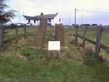
[[File:{{#var:Pnimage}}|thumb|right|500px|Robin Hood's Bow Stones, Lyme Handley / [https://www.geograph.org.uk/photo/2027668 John Darch, 20 Aug. 2010, Creative Commons, via Geograph.]]]<div class="no-img"> | [[File:{{#var:Pnimage}}|thumb|right|500px|Robin Hood's Bow Stones, Lyme Handley / [https://www.geograph.org.uk/photo/2027668 John Darch, 20 Aug. 2010, Creative Commons, via Geograph.]]]<div class="no-img"> | ||
| Line 11: | Line 11: | ||
For the alleged connection between this monument and others in the High Peak, see [[High Peak place-name cluster]]. | For the alleged connection between this monument and others in the High Peak, see [[High Peak place-name cluster]]. | ||
{{PnItemQry}} | {{PnItemQry}} | ||
== Quotes == | |||
<div class="plainquote">[Daniel & Samuel Lysons 1810:] ''Ancient Crosses.'' — Two very ancient stone-pillars, called the <keyword>Bow-stones</keyword>, or Park-moor-stones, fixed in a large stone, six feet four inches in length, and four feet in width, in form approaching to an oval, stand just without the eastern boundary of Lyme-park, near an ancient road, leading from Disley to Macclesfield: one of them is three feet two inches in height, and four feet three inches in girth at the base; the other four feet in height, and four feet in girth, at the base; the socket of each is eleven inches deep: they are round, and taper gradually from their bases: each of these pillars has a kind of rude capital, like those of the pillar near Valle-Crucis abbey in Denbighfhire.<ref>{{:Lysons, Daniel 1806a}}, vol. II, p. 459.</ref></div> | |||
== Gazetteers == | == Gazetteers == | ||
* Not included in {{:Dobson, Richard Barrie 1976a}}, pp. 293-11. | * Not included in {{:Dobson, Richard Barrie 1976a}}, pp. 293-11. | ||
== Sources == | == Sources == | ||
* {{:Lysons, Daniel 1806a}}, vol. II, p. 459 | |||
* {{:Marriott, William 1810a}}, pp. 18-27; also see pp. 1-3, 34-37, 224-48, and ''passim''. | * {{:Marriott, William 1810a}}, pp. 18-27; also see pp. 1-3, 34-37, 224-48, and ''passim''. | ||
== Maps == | == Maps == | ||
Revision as of 15:58, 17 June 2020
[[File:|thumb|right|500px|Robin Hood's Bow Stones, Lyme Handley / John Darch, 20 Aug. 2010, Creative Commons, via Geograph.]]
By Henrik Thiil Nielsen, 2019-02-20. Revised by Henrik Thiil Nielsen, 2020-06-17.
The Bowstones, situated beside the old Disley–Macclesfield ridgeway, overlooking Lyme Park, the Cheshire Plain, the City of Manchester and the Peak District, were known as Robin Hood's Stones, Bow Stones and Picking Stones in 1810.
William Marriott noted these folk names (see Allusions below) in the course of an extensive discussion of these and other stones he believed to be related. He generally used their more common name 'Bow Stones' (now usually spelled 'Bowstones'). The stones originally formed the shafts of an anglian cross, the western being 1.22 metres high, tapering from a diameter of c. 40 cm at the base to c. 27 cm at the top, the eastern being 98 cm high and c. 40 cm in diameter. The stones have interlaced carvings in a style indicating a date no later than the 10th century. It has been suggested that they were moved to their present location and fitted into a stone base by Sir Piers Legh of Lyme Hall in the 16th century. Two cross heads on display at the hall may originally have surmounted the shafts. The stones are a scheduled monument. Thanks in part to their location on a prominent ridgeline on the edge of the Peak District National Park with extensive views the site is well-visited.[1]
Current local tradition ascribes the stones' name to their having been used by Robin Hood and his men to string their bows.[2] A similar tradition is connected with Robin Hood's Picking Rods at Ludworth Intake near Chisworth. Despite the apparently still current traditions, there is no evidence that folk names connecting them with Robin Hood are atill in use.
For the alleged connection between this monument and others in the High Peak, see High Peak place-name cluster. Template:PnItemQry
Quotes
Gazetteers
- Not included in Dobson, R. B., ed.; Taylor, J., ed. Rymes of Robyn Hood: an Introduction to the English Outlaw (London, 1976), pp. 293-11.
Sources
- Lysons, Daniel; Lysons, Samuel. Magna Britannia; being A Concise Topographical Account of the Several Counties of Great Britain (London, 1806-22), vol. II, p. 459
- Marriott, William. The Antiquities of Lyme and its Vicinity (Stockport, 1810), pp. 18-27; also see pp. 1-3, 34-37, 224-48, and passim.
Maps
- 6" O.S. map Cheshire XXIX (1881; surveyed 1870-71)
- 6" O.S. map Cheshire XXIX.NW (1899; rev. 1896) (georeferenced)
- 6" O.S. map Cheshire XXIX.NW (1899; rev. 1896)
- 6" O.S. map Cheshire XXIX.NW (c. 1910; rev. 1907)
- 6" O.S. map Derbyshire VIII (1924; rev. 1919-20)
- 6" O.S. map Cheshire XXIX.NW (c. 1934; rev. 1907)
- 6" O.S. map Cheshire XXIX.NW (c. 1946; rev. 1938)
- 25" O.S. map Cheshire XXIX.6 (1873; surveyed 1870)
- 25" O.S. map Cheshire XXIX.6 (1897; rev. 1896) (georeferenced)
- 25" O.S. map Cheshire XXIX.6 (1897; rev. 1896)
- 25" O.S. map Cheshire XXIX.6 (1909; rev. 1907).
Background
- Biden, H. B. 'The Stretford Stone and its Kindred', The South Manchester Gazette (27 June 1885), p. ?; not seen
- Cox, J. Charles. 'Early Crosses in the High Peak', The Athenæum, No. 4002 (9 July 1904), pp. 56-58; see p. 57 (ter)
- Crofton, H. T. A History of the Ancient Chapel of Stretford in Manchester Parish, including Sketches of the Township of Stretford together with Notices of Local Families and Persons (Remains Historical and Literary connected with the Palatine Counties of Lancaster and Cheshire, New series, vols. 42, 45 and 51) (Manchester, 1899-1903), vol. III, p. 46, 47, 48 (volume publ. 1903); discussed in connection with similar monuments elsewhere
- Crofton, H. T. 'Agrimensorial Remains round Manchester', Transactions of the Lancashire and Cheshire Antiquarian Society, vol. XXIII (1905), pp. 112-71; see pp. 137, 167
- Megalithic Portal: Bowstones – Ancient Cross in England in Cheshire
- PastScape: The Bow Stones
- Renaud, Frank. Contributions towards a History of the Ancient Parish of Prestbury, in Cheshire (Remains Historical and Literary connected with the Palatine Counties of Lancaster and Cheshire, vol. XCVII) (Manchester, 1876), pp. 71, 144
- Wikipedia: Bowstones.
Notes
- ↑ This account is mainly based on Megalithic Portal: Bowstones – Ancient Cross in England in Cheshire; PastScape: The Bow Stones; Wikipedia: Bowstones.
- ↑ Wikipedia: Bowstones.
- ↑ Lysons, Daniel; Lysons, Samuel. Magna Britannia; being A Concise Topographical Account of the Several Counties of Great Britain (London, 1806-22), vol. II, p. 459.
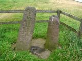
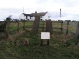
The Bow Stones / John Darch, 20 Aug. 2010, Creative Commons, via Geograph.
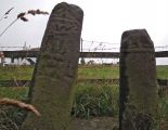
The Bow Stones / Stephen Burton, 11 Sep. 2013, Creative Commons, via Geograph.
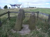
The Bow Stones / Anthony Parkes, 6 Sep. 2015, Creative Commons, via Geograph.

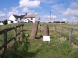
Bow Stones and Bowstonegate Farm / Chris Morgan, 7 Nov. 2012, Creative Commons, via Geograph.
Bow Stones and Bowstonegate Farm / Raymond Knapman, 11 Apr. 2009, Creative Commons, via Geograph.
The Bow Stones, a historical site above Lyme Park on the Gritstone Trail / Dave Shandley, 24 Mar. 2007, Creative Commons, via Geograph.
The Bow Stones / Dave Dunford, 8 Jan. 2005, Creative Commons, via Geograph.
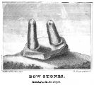
The Bow Stones / Marriott, William - Antiquities of Lyme and its Vicinity, placte facing p. 2.
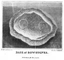
The base or socket of the The Bow Stones / Marriott, William - Antiquities of Lyme and its Vicinity, placte facing p. 303.
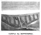
Ancient encampment near the Bow Stones / Marriott, William - Antiquities of Lyme and its Vicinity, placte facing p. 230.


