
Plumpton Park (Barlow, Selby): Difference between revisions
m (Text replacement - "PlaceNamesItemQuery" to "PlaceNamesItemAllusionsAndRecords") |
mNo edit summary |
||
| Line 1: | Line 1: | ||
__NOTOC__{{PlaceNamesItemTop|Lat=53. | __NOTOC__{{PlaceNamesItemTop|Lat=53.766414|Lon=-1.044304|AdministrativeDivision=Yorkshire|Vicinity=''c.'' 500 m SE of Selby|Type=Area|Interest=Literary locale|Status=Defunct|Demonym=|Riding=West|GreaterLondon=|Year=1500|Aka=|Century=|Cluster1=|Cluster2=|Cluster3=|Image=barlow-grange-google-earth-street-view.jpg|Postcards=|ExtraCat1=Places named Plumpton Park|ExtraCat2=Place-names in Gest of Robyn Hode|ExtraCat3=|ExtraCat4=|ExtraCat5=|ExtraLink1=|GeopointPrefix=Near |GeopointSuffix=|StatusSuffix=|DatePrefix=''c. ''|DateSuffix=}} | ||
{{#display_map:{{#var:Coords}}~{{#replace:{{PAGENAME}}|'|'}}|width=34%|enablefullscreen=yes}}<div class="pnMapLegend">Plumpton Park | {{#display_map:{{#var:Coords}}~{{#replace:{{PAGENAME}}|'|'}}|width=34%|enablefullscreen=yes}}<div class="pnMapLegend">Plumpton Park would have been located not very far from the point indicated.</div> | ||
[[File:{{#var:Image}}|thumb|right|500px|Barlow Grange, north of which was a locality known as Plumpton Park in the late 18th century / Google Earth Street View.]]<div class="no-img"> | [[File:{{#var:Image}}|thumb|right|500px|Barlow Grange, north or west of which was a locality known as Plumpton Park in the late 18th century / Google Earth Street View.]]<div class="no-img"> | ||
<p id="byline">By Henrik Thiil Nielsen, 2013-07-18. Revised by {{#realname:{{REVISIONUSER}}}}, {{REVISIONYEAR}}-{{REVISIONMONTH}}-{{REVISIONDAY2}}.</p> | <p id="byline">By Henrik Thiil Nielsen, 2013-07-18. Revised by {{#realname:{{REVISIONUSER}}}}, {{REVISIONYEAR}}-{{REVISIONMONTH}}-{{REVISIONDAY2}}.</p> | ||
In the ''[[Gest of Robyn Hode|Gest]]'', King Edward is exasperated at noticing the scarcity of deer in Plumpton Park after Robin and his men have been poaching there during their stay with the knight. We should almost certainly take this to be in Lancashire, but it could just possibly be some place King Edward is meant to have visited after his progress in Lancashire. | In the ''[[Gest of Robyn Hode|Gest]]'', King Edward is exasperated at noticing the scarcity of deer in Plumpton Park after Robin and his men have been poaching there during their stay with the knight. We should almost certainly take this to be in Lancashire, but it could just possibly be some place King Edward is meant to have visited after his progress in Lancashire. | ||
A 'Plumpton Park' is indicated on Jeffery's 1772 ''Map of Yorkshire'' in an area that ,must be located ''c.'' 500 southeast of Selby, slightly north or west of Barlow Grange. The map has it south of 'Old Carr Wood', north of 'Brackenhill and 'Botany Bay Inn'.<ref>{{:Jefferys, Thomas 1772a}}, sheet 8, row 2, tile 3; [https://huddersfield.exposed/wiki/Jefferys%27_Map_of_Yorkshire_(1771)_-_sheet_8#customview=-143.4375:166.375:4 web edition at Huddersfield Exposed, digitised by McMaster University.] Also see [http://www.victoriacountyhistory.ac.uk/sites/default/files/work-in-progress/barlow_introduction.pdf Barlow: Introduction to forthcoming ''VCH'' volume,] pp. 5-6.</ref> The name may have applied more or less the area now bounded by the A63 on the north, East Common Lane to the east, Thief Lane to the south, and the A1041 to the west. A. H. Smith notes this place-name, citing an 1841 Ordnance Survey map as his source.<ref>{{:Smith, Albert Hugh 1961a}}, pt. IV, p. 24.</ref> IRHB has found no entry relating to this Plumpton Park in the tithe awards for Barlow, Burn, Drax or Selby. | |||
{{PlaceNamesItemAllusionsAndRecords}} | |||
== Quotations == | == Quotations == | ||
{{quote|[''Gest''; ''c.'' 1500:]<br/> | {{quote|[''Gest''; ''c.'' 1500:]<br/> | ||
| Line 13: | Line 14: | ||
He faylyd many of his dere.<ref>''[[Gest of Robyn Hode|Gest]]'', st. 357.</ref>}} | He faylyd many of his dere.<ref>''[[Gest of Robyn Hode|Gest]]'', st. 357.</ref>}} | ||
== Maps == | == Maps == | ||
* {{:Jefferys, Thomas 1772a}}, sheet 8, row 2, tile 3 | |||
** [https://huddersfield.exposed/wiki/Jefferys%27_Map_of_Yorkshire_(1771)_-_sheet_8#customview=-143.4375:166.375:4 web edition at Huddersfield Exposed, digitised by McMaster University] | |||
* [https://maps.nls.uk/view/125642893#zoom=4&lat=9591&lon=15133&layers=BT 25" O.S. map ''Yorkshire'' CCXXI.15 (1892; surveyed 1888)] | * [https://maps.nls.uk/view/125642893#zoom=4&lat=9591&lon=15133&layers=BT 25" O.S. map ''Yorkshire'' CCXXI.15 (1892; surveyed 1888)] | ||
* [https://maps.nls.uk/view/125642896#zoom=4&lat=9727&lon=14919&layers=BT 25" O.S. map ''Yorkshire'' CCXXI.15 (1907; rev. 1905)] | * [https://maps.nls.uk/view/125642896#zoom=4&lat=9727&lon=14919&layers=BT 25" O.S. map ''Yorkshire'' CCXXI.15 (1907; rev. 1905)] | ||
| Line 40: | Line 43: | ||
{{PlaceNamesItemNavigation}} | {{PlaceNamesItemNavigation}} | ||
{{ImageGalleryIntroduction}} | |||
<gallery widths="195px"> | |||
Jefferys thomas 1772a sheet8 row2 tile3.jpg|Plumpton Park / {{:Jefferys thomas 1772a}} sheet8 row2 tile3; [https://huddersfield.exposed/wiki/Jefferys%27_Map_of_Yorkshire_(1771)_-_sheet_8#customview=-143.4375:166.375:4 web edition at Huddersfield Exposed, digitised by McMaster University.] | |||
barlow-grange-google-earth-street-view.jpg|Barlow Grange, north or west of which was a locality known as Plumpton Park in the late 18th century / Google Earth Street View. | |||
</gallery> | |||
Revision as of 05:43, 31 May 2021
| Locality | |
|---|---|
| Coordinate | Near 53.766414, -1.044304 |
| Adm. div. | West Riding of Yorkshire |
| Vicinity | c. 500 m SE of Selby |
| Type | Area |
| Interest | Literary locale |
| Status | Defunct |
| First Record | c. 1500 |

By Henrik Thiil Nielsen, 2013-07-18. Revised by Henrik Thiil Nielsen, 2021-05-31.
In the Gest, King Edward is exasperated at noticing the scarcity of deer in Plumpton Park after Robin and his men have been poaching there during their stay with the knight. We should almost certainly take this to be in Lancashire, but it could just possibly be some place King Edward is meant to have visited after his progress in Lancashire.
A 'Plumpton Park' is indicated on Jeffery's 1772 Map of Yorkshire in an area that ,must be located c. 500 southeast of Selby, slightly north or west of Barlow Grange. The map has it south of 'Old Carr Wood', north of 'Brackenhill and 'Botany Bay Inn'.[1] The name may have applied more or less the area now bounded by the A63 on the north, East Common Lane to the east, Thief Lane to the south, and the A1041 to the west. A. H. Smith notes this place-name, citing an 1841 Ordnance Survey map as his source.[2] IRHB has found no entry relating to this Plumpton Park in the tithe awards for Barlow, Burn, Drax or Selby.
Quotations
[Gest; c. 1500:]
All the passe of Lancasshyre
went both ferre and nere
Tyll he came to Plomton Parke
He faylyd many of his dere.[3]
Maps
- Jefferys, Thomas, cartog. The County of York. Survey'd in MDCCLXVII., VIII., IX., and MDCCLXX (London, 1772), sheet 8, row 2, tile 3
- 25" O.S. map Yorkshire CCXXI.15 (1892; surveyed 1888)
- 25" O.S. map Yorkshire CCXXI.15 (1907; rev. 1905)
- 25" O.S. map Yorkshire .15 (1907; rev. 1905) (georeferenced)
- 6" O.S. map Yorkshire 221 (1851; surveyed 1845-47)
- 6" O.S. map Yorkshire CCXXI.SE (1893; surveyed 1888-90)
- 6" O.S. map Yorkshire CCXXI.SE (1908; rev. 1905)
- 6" O.S. map Yorkshire CCXXI.SE (1908; rev. 1905) (georeferenced)
- 6" O.S. map Yorkshire CCXXI.SE (1948; rev. 1938)
- 6" O.S. map Yorkshire CCXXI.SE (1952; rev. 1950).
Sources
- A Gest of Robyn Hode, st. 357.
- Ordnance Survey map of the area (1841) cf. A. H. Smith below. Not seen.
- Smith, A.H. The Place-Names of the West Riding of Yorkshire (English Place-Name Society, vols. XXX-XXXVII) (Cambridge, 1961-63), pt. IV, p. 24.
- Barlow: Introduction to forthcoming VCH volume.
Also see
Notes
- ↑ Jefferys, Thomas, cartog. The County of York. Survey'd in MDCCLXVII., VIII., IX., and MDCCLXX (London, 1772), sheet 8, row 2, tile 3; web edition at Huddersfield Exposed, digitised by McMaster University. Also see Barlow: Introduction to forthcoming VCH volume, pp. 5-6.
- ↑ Smith, A.H. The Place-Names of the West Riding of Yorkshire (English Place-Name Society, vols. XXX-XXXVII) (Cambridge, 1961-63), pt. IV, p. 24.
- ↑ Gest, st. 357.
Image gallery
Click any image to display it in the lightbox, where you can navigate between images by clicking in the right or left side of the current image.
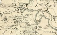
Plumpton Park / Jefferys thomas 1772a sheet8 row2 tile3; web edition at Huddersfield Exposed, digitised by McMaster University.
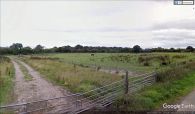
Barlow Grange, north or west of which was a locality known as Plumpton Park in the late 18th century / Google Earth Street View.
