
Pinner Court (Grays Inn Road): Difference between revisions
m (→Maps) |
mNo edit summary |
||
| Line 5: | Line 5: | ||
[[File:15-bloomsbury-pinner-court.jpg|thumb|right|500px|Pinner Court was just right of the red ellipse / [http://www.mappalondon.com/london/north-west/bloomsbury.jpg Edward Stanford's ''Library Map of London'' (1862-71), Bloomsbury section.]]] | [[File:15-bloomsbury-pinner-court.jpg|thumb|right|500px|Pinner Court was just right of the red ellipse / [http://www.mappalondon.com/london/north-west/bloomsbury.jpg Edward Stanford's ''Library Map of London'' (1862-71), Bloomsbury section.]]] | ||
<p id="byline">By Henrik Thiil Nielsen, 2018-01-16. Revised by {{#realname:{{REVISIONUSER}}}}, {{REVISIONYEAR}}-{{REVISIONMONTH}}-{{REVISIONDAY2}}.</p><div class="no-img"> | <p id="byline">By Henrik Thiil Nielsen, 2018-01-16. Revised by {{#realname:{{REVISIONUSER}}}}, {{REVISIONYEAR}}-{{REVISIONMONTH}}-{{REVISIONDAY2}}.</p><div class="no-img"> | ||
' | 'Pinner-Court' was the 19th century name for the present 52 and/or 54 Grays Inn Road. There were then two short, narrow cul-de-sacs there. One of them was Pinner Court, a name that is probably inspired by the presence of the [[Pindar of Wakefield (Grays Inn Road)|Pindar of Wakefield]] public house on Grays Inn Road. | ||
The street name is not included on any of the early maps I have seen, but Lockie's ''Topography'' (1810) notes that it is located on "Gray's-Inn-Lane,—at 35, that number on the R. from Middle-row, Holborn".<ref>{{:Lockie, John 1810a}}, ''s.n.'' Pinner-Court [1]</ref>. Since he has Bell Court at No. 22, Portpool Lane at No. 52, and notes that Baldwin's Gardens leads to 32 Grays Inn Lane (later Gray's Inn Road),<ref>{{:Lockie, John 1810a}}, ''s.nn.'' Bell-Court [2], Portpool-lane, Baldwin's-Gardens.</ref> the location can be established with reasonable certainty.{{#ask:[[Category:Records ({{#ifeq:{{#pos:{{PAGENAME}}|(|}}||{{PAGENAME}}|{{#sub:{{PAGENAME}}|0| {{#expr:{{#pos:{{PAGENAME}}|(|}}-1}} }},{{#sub:{{PAGENAME}}|{{#expr:{{#pos:{{PAGENAME}}|(|}}-1}}|1}}{{#sub:{{PAGENAME}}|{{#expr:{{#pos:{{PAGENAME}}|(|}}+1}}}}}}]]| format=embedded|embedformat=h4|columns=1|limit=1000|sort=Utitle|intro=<h3>Records</h3>}} | |||
{{#ask:[[Category:Allusions ({{#ifeq:{{#pos:{{PAGENAME}}|(|}}||{{PAGENAME}}|{{#sub:{{PAGENAME}}|0| {{#expr:{{#pos:{{PAGENAME}}|(|}}-1}} }},{{#sub:{{PAGENAME}}|{{#expr:{{#pos:{{PAGENAME}}|(|}}-1}}|1}}{{#sub:{{PAGENAME}}|{{#expr:{{#pos:{{PAGENAME}}|(|}}+1}}}}}}]]| format=embedded|embedformat=h4|columns=1|limit=1000|sort=Utitle|intro=<h3>Allusions</h3>}} | {{#ask:[[Category:Allusions ({{#ifeq:{{#pos:{{PAGENAME}}|(|}}||{{PAGENAME}}|{{#sub:{{PAGENAME}}|0| {{#expr:{{#pos:{{PAGENAME}}|(|}}-1}} }},{{#sub:{{PAGENAME}}|{{#expr:{{#pos:{{PAGENAME}}|(|}}-1}}|1}}{{#sub:{{PAGENAME}}|{{#expr:{{#pos:{{PAGENAME}}|(|}}+1}}}}}}]]| format=embedded|embedformat=h4|columns=1|limit=1000|sort=Utitle|intro=<h3>Allusions</h3>}} | ||
=== Gazetteers === | === Gazetteers === | ||
* Not included in {{:Dobson, Richard Barrie 1976a}}, pp. 293-311. | * Not included in {{:Dobson, Richard Barrie 1976a}}, pp. 293-311. | ||
=== Sources === | |||
* {{:Lockie, John 1810a}}, ''s.n.'' Pinner-Court [1]. | |||
** {{:Lockie, John 1813a}}, ''s.n.'' Pinner-Court [1]. | |||
=== Maps === | === Maps === | ||
* [http://www.mappalondon.com/london/north-west/bloomsbury.jpg Edward Stanford's ''Library Map of London'' (1862-71), Bloomsbury section.] | * [http://www.mappalondon.com/london/north-west/bloomsbury.jpg Edward Stanford's ''Library Map of London'' (1862-71), Bloomsbury section.] | ||
Revision as of 21:32, 19 January 2018
[[File:|thumb|right|500px|Pinner Court was located at or near the present 52 and/or 54 Gray Inns Road / Google Earth Street View.]]

By Henrik Thiil Nielsen, 2018-01-16. Revised by Henrik Thiil Nielsen, 2018-01-19.
'Pinner-Court' was the 19th century name for the present 52 and/or 54 Grays Inn Road. There were then two short, narrow cul-de-sacs there. One of them was Pinner Court, a name that is probably inspired by the presence of the Pindar of Wakefield public house on Grays Inn Road.
The street name is not included on any of the early maps I have seen, but Lockie's Topography (1810) notes that it is located on "Gray's-Inn-Lane,—at 35, that number on the R. from Middle-row, Holborn".[1]. Since he has Bell Court at No. 22, Portpool Lane at No. 52, and notes that Baldwin's Gardens leads to 32 Grays Inn Lane (later Gray's Inn Road),[2] the location can be established with reasonable certainty.
Gazetteers
- Not included in Dobson, R. B., ed.; Taylor, J., ed. Rymes of Robyn Hood: an Introduction to the English Outlaw (London, 1976), pp. 293-311.
Sources
Maps
- Edward Stanford's Library Map of London (1862-71), Bloomsbury section.
- 25" O.S. map London XXVI (1936; rev. 1914)
- 6" O.S. map Middlesex XVII (1880-82; surveyed 1868-73)
- 6" O.S. map Surrey III (1880; surveyed 1868-73)
- 6" O.S. map London VII.SW (1894-96; rev. 1893-95)
- 6" O.S. map Surrey III.NW (1898; rev. 1893-95)
- 6" O.S. map London sheet K (1920; rev. 1913-14)
- 6" O.S. map London sheet K (c. 1946; rev. 1938).
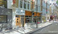
Pinner Court was located at or near the present 52 and/or 54 Gray Inns Road / Google Earth Street View.
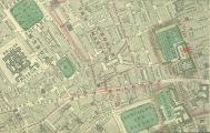
Pinner Court was just right of the red ellipse / Edward Stanford's Library Map of London (1862-71), Bloomsbury section.

- ↑ Lockie, John, compil. Lockie's Topography of London, Giving a Concise Local Description of and Accurate Direction to Every Square, Street, Lane, Court, Dock, Wharf, Inn, Public Office, &c. in the Metropolis and its Environs (London, 1810), s.n. Pinner-Court [1]
- ↑ Lockie, John, compil. Lockie's Topography of London, Giving a Concise Local Description of and Accurate Direction to Every Square, Street, Lane, Court, Dock, Wharf, Inn, Public Office, &c. in the Metropolis and its Environs (London, 1810), s.nn. Bell-Court [2], Portpool-lane, Baldwin's-Gardens.