
Marian's Walk (Forest of Dean): Difference between revisions
m (Text replacement - "AdmDiv" to "AdministrativeDivision") |
m (Text replacement - "PnItemTop" to "PlaceNamesItemTop") |
||
| Line 1: | Line 1: | ||
__NOTOC__{{ | __NOTOC__{{PlaceNamesItemTop|Lat=51.808977|Lon=-2.623055|AdministrativeDivision=Gloucestershire|Vicinity=Alongside Grove Road, Berry Hill, ''c.'' 800 m NNW of Coleford|Type=Thoroughfare|Interest=Robin Hood name|Status=Extant|Demonym=English|Riding=|GreaterLondon=|Year=|Aka=|Century=20|Cluster1=Forest of Dean|Cluster2=|Cluster3=|Image=marians-walk-forest-of-dean.jpg|Postcards=|ExtraCat1=Places named after Maid Marian|ExtraCat2=|ExtraCat3=|ExtraCat4=|ExtraCat5=|ExtraLink1=|ExtraLink2=|ExtraLink3=|ExtraLink4=|ExtraLink5=|ExtraLinkName1=|ExtraLinkName2=|ExtraLinkName3=|ExtraLinkName4=|ExtraLinkName5=|GeopointPrefix=|GeopointSuffix=|StatusSuffix=|DatePrefix=|DateSuffix=}} | ||
{{#display_map:{{#var:Coords}}~{{#replace:{{PAGENAME}}|'|'}}|width=34%|enablefullscreen=yes}}<div class="pnMapLegend">Marian's Walk, Forest of Dean</div> | {{#display_map:{{#var:Coords}}~{{#replace:{{PAGENAME}}|'|'}}|width=34%|enablefullscreen=yes}}<div class="pnMapLegend">Marian's Walk, Forest of Dean</div> | ||
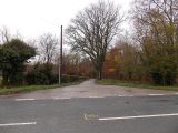
[[File:{{#var:Image}}|thumb|right|500px|Marian's Walk, Forest of Dean / [http://www.geograph.org.uk/photo/4260317 Jaggery, 23 Nov. 2014; Creative Commons, via Geograph.]]]<div class="no-img"> | [[File:{{#var:Image}}|thumb|right|500px|Marian's Walk, Forest of Dean / [http://www.geograph.org.uk/photo/4260317 Jaggery, 23 Nov. 2014; Creative Commons, via Geograph.]]]<div class="no-img"> | ||
Revision as of 23:55, 5 January 2021
| Locality | |
|---|---|
| Coordinate | 51.808977, -2.623055 |
| Adm. div. | Gloucestershire |
| Vicinity | Alongside Grove Road, Berry Hill, c. 800 m NNW of Coleford |
| Type | Thoroughfare |
| Interest | Robin Hood name |
| Status | Extant |
| First Record | |

By Henrik Thiil Nielsen, 2018-10-14. Revised by Henrik Thiil Nielsen, 2021-01-05.
A lane running alongside Grove Road in Berry Hill, less than one km NNW of Coleford, is named Marian's Walk.
The street name is not included on any of the O.S. maps listed below. This fact together with the look of the houses along it (see photo below) suggests that the walk dates from the second half of the 20th century. It is one of a handful of localities or thoroughfares in the area with "Marian" in their names that may all directly or indirecly owe their names to the existence of a Robin Hood inn in the area in the first half of the 19th century.Template:PnItemQry
Gazetteers
- Not included in Dobson, R. B., ed.; Taylor, J., ed. Rymes of Robyn Hood: an Introduction to the English Outlaw (London, 1976), pp. 293-11.
Maps
- 25" O.S. map Gloucestershire XXX.16 (1881; surveyed 1877-79)
- 25" O.S. map Gloucestershire XXX.16 (1902; rev. 1900) (georeferenced)]
- 25" O.S. map Gloucestershire XXX.16 (1902; rev. 1900)
- 25" O.S. map Gloucestershire XXX.16 (1922; rev. 1920)
- 6" O.S. map Gloucestershire XXX.SE (1884; surveyed 1878-80)
- 6" O.S. map Gloucestershire XXX.SE (1903; rev. 1900) (georeferenced)
- 6" O.S. map Gloucestershire XXX.SE (1903; rev. 1900)
- 6" O.S. map Monmouthshire XV (1924; rev. 1918)
- 6" O.S. map Gloucestershire XXX (1924; rev. 1920-21)
- 6" O.S. map Gloucestershire XXX.SE (1924; rev. 1920)
- 6" O.S. map Gloucestershire XXX.SE (c. 1935; rev. 1920)
- 6" O.S. map Gloucestershire XXX.SE (1953; rev. 1943)
- 6" O.S. map Monmouthshire XV (1953; rev. 1943-49).
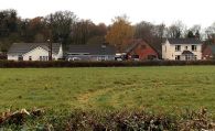
Marian's Walk, Forest of Dean / Jaggery, 23 Nov. 2014; Creative Commons, via Geograph.
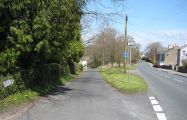
Marian's Walk / Pauline E, 15 Apr. 2008; Creative Commons, via Geograph.
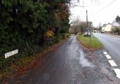
Marian's Walk / Jaggery, 23 Nov. 2014; Creative Commons, via Geograph.
Electricity substation on the corner of Grove Road and Marians Walk / Jaggery, 23 Nov. 2014; Creative Commons, via Geograph.
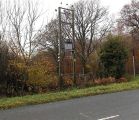
Northern end of Marians Walk, Berry Hill, on the west side of Grove Road / Jaggery, 23 Nov. 2014; Creative Commons, via Geograph.


