Maid Marion Rise (Warsop): Difference between revisions
From International Robin Hood Bibliography
m (Text replacement - "ImgGalleryIntro" to "ImageGalleryIntroduction") |
m (Text replacement - "No Copy in NLS" to "No copy in NLS") |
||
| Line 9: | Line 9: | ||
<!--== Sources ==--> | <!--== Sources ==--> | ||
== Maps == | == Maps == | ||
* 25" O.S. map ''Nottinghamshire'' XXIII.14 (''c.'' 1885; surveyed c''. '' 1883). No | * 25" O.S. map ''Nottinghamshire'' XXIII.14 (''c.'' 1885; surveyed c''. '' 1883). No copy in NLS | ||
* 25" O.S. map ''Nottinghamshire'' XXIII.14 (''c.'' 1898; rev. c''. '' 1897). No | * 25" O.S. map ''Nottinghamshire'' XXIII.14 (''c.'' 1898; rev. c''. '' 1897). No copy in NLS | ||
* [https://maps.nls.uk/view/115390024#zoom=4&lat=4746&lon=6009&layers=BT 25" O.S. map ''Nottinghamshire'' XXIII.14 (1918; rev. 1914)] | * [https://maps.nls.uk/view/115390024#zoom=4&lat=4746&lon=6009&layers=BT 25" O.S. map ''Nottinghamshire'' XXIII.14 (1918; rev. 1914)] | ||
* [http://maps.nls.uk/geo/explore/#zoom=17&lat=53.2019&lon=-1.1502&layers=168&b=5 25" O.S. map ''Nottinghamshire'' XXIII.14 (1918; rev. 1914)] (georeferenced) | * [http://maps.nls.uk/geo/explore/#zoom=17&lat=53.2019&lon=-1.1502&layers=168&b=5 25" O.S. map ''Nottinghamshire'' XXIII.14 (1918; rev. 1914)] (georeferenced) | ||
Latest revision as of 01:03, 13 February 2021
| Locality | |
|---|---|
| Coordinate | 53.203847, -1.149921 |
| Adm. div. | Nottinghamshire |
| Vicinity | Side street on E side of Sherwood Street in Warsop |
| Type | Establishment |
| Interest | Robin Hood name |
| Status | Extant |
| First Record | |
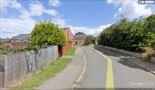
Maid Marion Rise, Warsop,
By Henrik Thiil Nielsen, 2018-05-20. Revised by Henrik Thiil Nielsen, 2021-02-13.
Maid Marion Rise is a residential cul-de-sac on the east side of Sherwood Street in Warsop. It seems to be of 20th century date.
Gazetteers
- Not included in Dobson, R. B., ed.; Taylor, J., ed. Rymes of Robyn Hood: an Introduction to the English Outlaw (London, 1976), pp. 293-311.
Maps
- 25" O.S. map Nottinghamshire XXIII.14 (c. 1885; surveyed c. 1883). No copy in NLS
- 25" O.S. map Nottinghamshire XXIII.14 (c. 1898; rev. c. 1897). No copy in NLS
- 25" O.S. map Nottinghamshire XXIII.14 (1918; rev. 1914)
- 25" O.S. map Nottinghamshire XXIII.14 (1918; rev. 1914) (georeferenced)
- 6" O.S. map Nottinghamshire XVIII.SW (1884; surveyed 1883-84)
- 6" O.S. map Nottinghamshire XVIII.SW (1900; rev. 1897)
- 6" O.S. map Nottinghamshire XVIII.SW (1900; rev. 1897) (georeferenced)
- 6" O.S. map Nottinghamshire XVIII.SW (1920; rev. 1914)
- 6" O.S. map Nottinghamshire XVIII.SW (c. 1949; rev. 1938).
Also see

