
Loxley (Bramshall)
[[File:|thumb|right|500px|Loxley Hall, Bramshall / Stephen Richards, 21 Aug. 2002, Creative Commons.]]
By Henrik Thiil Nielsen, 2020-10-12. Revised by Henrik Thiil Nielsen, 2020-10-12.
The Sloane MS Life of Robin Hood from c. 1600 connects Robin Hood with a place or an area named Loxley. One of several possibilities is a neighbourhood south-west of Uttoxeter, Staffordshire. The names of several localities here include the element 'Loxley', though none appears to be named 'Loxley' tout court.
About one km south of Bramshall and two km south-west of Uttoxeter lies the early-19th-century country house Loxley Hall,[1] which is now home to Loxley Hall School, a 'special school for children with social, emotional and mental health difficulties with resulting behavioural problems'.[2] South of the hall lie Loxley Park, Lower Loxley, Loxley Bank, Loxley Green, Loxley Green Farm etc.
John Marius Wilson in his Imperial Gazetteer of England and Wales (1870), noted this area as 'Loxley, a liberty in Uttoxeter parish', where 'Robin Hood is said to have been a native, and to have had here one of his forest haunts'.[3] He noted no similar traditions relating to the only other Loxley he included, Loxley near Stratford-upon-Avon).[4] Much more recently a local pundit helped BBC draw up a short list of the credentials of this neighbourhood. but the evidence that could be mustered is late, peripheral and not very plentiful.[5] Template:PnItemQry
Gazetteers
- Not included in Dobson, R. B., ed.; Taylor, J., ed. Rymes of Robyn Hood: an Introduction to the English Outlaw (London, 1976), pp. 293-311.
Sources
- Wilson, John Marius, comp. The Imperial Gazetteer of England and Wales: embracing Recent Changes in Counties, Dioceses, Parishes, and Boroughs, General Statistics, Postal Arrangements, Railway Systems, &c.; and forming a Complete Description of the Country (Edinburgh, Glasgow, London, Dublin, [1870]), vol. IV, p. 210, s.nn. Loxley [1], Loxley [2].
Maps
- 25" O.S. map Staffordshire XXXII.5 (1901; rev. 1899) (georeferenced)
- 25" O.S. map Staffordshire XXXII.5 (c. 1882; surveyed c. 1881). No Copy in NLS
- 25" O.S. map Staffordshire XXXII.5 (1901; rev. 1899)
- 25" O.S. map Staffordshire XXXII.5 (1923; rev. 1920)
- 25" O.S. map Staffordshire XXXI.8 (c. 1882; surveyed c. 1880–81). No Copy in NLS
- 25" O.S. map Staffordshire XXXI.8 (1901; rev. 1900)
- 25" O.S. map Staffordshire XXXI.8 (1924; rev. 1922)
- 25" O.S. map Staffordshire XXXII.9 (c. 1883; surveyed c. 1879). No Copy in NLS
- 25" O.S. map Staffordshire XXXII.9 (1901; rev. 1899)
- 25" O.S. map Staffordshire XXXII.9 (1923; rev. 1922).
- 6" O.S. map Staffordshire XXXI.NE (1887; surveyed 1880–81)
- 6" O.S. map Staffordshire XXXI.NE (1925; rev. 1922)
- 6" O.S. map Staffordshire XXXI.NE (1901; rev. 1900).
- 6" O.S. map Staffordshire XXXII.NW (1901; rev. 1899–1900) (georeferenced)
- 6" O.S. map Staffordshire XXXII.NW (1901; rev. 1899–1900)
- 6" O.S. map Staffordshire XXXII.NW (1884; surveyed 1881)
- 6" O.S. map Staffordshire XXXII.SW (1901; rev. 1899–1900)
- 6" O.S. map Staffordshire XXXII.SW (1884; surveyed 1881–82)
- 6" O.S. map Derbyshire LII (c. 1949; rev. 1938)
- 6" O.S. map Derbyshire LII (1924; rev. 1920)
Discussion
Background
Notes
- ↑ Wikipedia: https://en.wikipedia.org/wiki/Loxley_Hall Wikipedia: Loxley Hall
- ↑ Loxley Hall School.
- ↑ Wilson, John Marius, comp. The Imperial Gazetteer of England and Wales: embracing Recent Changes in Counties, Dioceses, Parishes, and Boroughs, General Statistics, Postal Arrangements, Railway Systems, &c.; and forming a Complete Description of the Country (Edinburgh, Glasgow, London, Dublin, [1870]), vol. IV, p. 210, s.n. Loxley [1].
- ↑ Wilson, John Marius, comp. The Imperial Gazetteer of England and Wales: embracing Recent Changes in Counties, Dioceses, Parishes, and Boroughs, General Statistics, Postal Arrangements, Railway Systems, &c.; and forming a Complete Description of the Country (Edinburgh, Glasgow, London, Dublin, [1870]), vol. IV, p. 210, s.n. Loxley [2].
- ↑ BBC: Stoke & Staffordshire > History > Local Heroes > Robin Hood ... of Staffordshire?
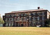
Loxley Hall, Bramshall / Stephen Richards, 21 Aug. 2002; Creative Commons, via Geograph.
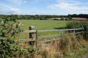
Field by Loxley Lane / Bill Boaden, 23 Aug. 2014; Creative Commons, via Geograph.
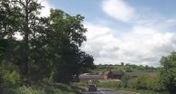
Lower Loxley Farm from A518 / John Firth, 15 July 2013; Creative Commons, via Geograph.
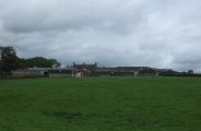
Loxley Bank Farm / JThomas 7 Oct. 2017; Creative Commons, via Geograph.


