
Locksley School (Tuckswood, Norwich): Difference between revisions
From International Robin Hood Bibliography
m (Text replacement - "PlaceNamesItemQuery" to "PlaceNamesItemAllusionsAndRecords") |
m (Text replacement - "ImgGalleryIntro" to "ImageGalleryIntroduction") |
||
| Line 14: | Line 14: | ||
<div id="gallery"> | <div id="gallery"> | ||
{{ | {{ImageGalleryIntroduction}} | ||
<gallery widths="195px"> | <gallery widths="195px"> | ||
File:locksley-school-tuckswood-google-earth-street-view.jpg|The Locksley School seen from Locksley Road / Google Earth Street View. | File:locksley-school-tuckswood-google-earth-street-view.jpg|The Locksley School seen from Locksley Road / Google Earth Street View. | ||
Latest revision as of 13:50, 7 January 2021
| Locality | |
|---|---|
| Coordinate | 52.605223, 1.281487 |
| Adm. div. | Norfolk |
| Vicinity | In Tuckswood, Peterkin Road/Locksley Road, Norwich |
| Type | Establishment |
| Interest | Miscellaneous |
| Status | Extant |
| First Record | |
Locksley School (Tuckswood, Norwich).

By Henrik Thiil Nielsen, 2018-01-11. Revised by Henrik Thiil Nielsen, 2021-01-07.
The Locksley School is one of many establishments and localities with Robin Hood-themed names in the Tuckswood area between Ipswich and Hall roads. Norwich.
Gazetteers
- Not included in Dobson, R. B., ed.; Taylor, J., ed. Rymes of Robyn Hood: an Introduction to the English Outlaw (London, 1976), pp. 293-311.
Also see
Image gallery
Click any image to display it in the lightbox, where you can navigate between images by clicking in the right or left side of the current image.
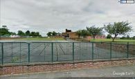
The Locksley School seen from Locksley Road / Google Earth Street View.
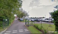
The Locksley School, entrance from Peterkin Road / Google Earth Street View.
