
Little Johns (Margaretting): Difference between revisions
From International Robin Hood Bibliography
m (Text replacement - "{{#ask:[[Category:Records ({{#ifeq:{{#pos:{{PAGENAME}}|(|}}||{{PAGENAME}}|{{#sub:{{PAGENAME}}|0| {{#expr:{{#pos:{{PAGENAME}}|(|}}-1}} }},{{#sub:{{PAGENAME}}|{{#expr:{{#pos:{{PAGENAME}}|(|}}-1}}|1}}{{#sub:{{PAGENAME}}|{{#expr:{{#pos:...) |
m (Text replacement - "{{#ask:[[Category:Records ({{#ifeq:{{#pos:{{PAGENAME}}|(|}}||{{PAGENAME}}|{{#sub:{{PAGENAME}}|0| {{#expr:{{#pos:{{PAGENAME}}|(|}}-1}} }},{{#sub:{{PAGENAME}}|{{#expr:{{#pos:{{PAGENAME}}|(|}}-1}}|1}}{{#sub:{{PAGENAME}}|{{#expr:{{#pos:...) |
||
| Line 4: | Line 4: | ||
[[File:{{#var:Pnimage}}|thumb|right|500px|Little Johns, Margaretting (red outline) / Google Earth Street View.]] | [[File:{{#var:Pnimage}}|thumb|right|500px|Little Johns, Margaretting (red outline) / Google Earth Street View.]] | ||
<p id="byline">By Henrik Thiil Nielsen, 2018-02-21. Revised by {{#realname:{{REVISIONUSER}}}}, {{REVISIONYEAR}}-{{REVISIONMONTH}}-{{REVISIONDAY2}}.</p><div class="no-img"> | <p id="byline">By Henrik Thiil Nielsen, 2018-02-21. Revised by {{#realname:{{REVISIONUSER}}}}, {{REVISIONYEAR}}-{{REVISIONMONTH}}-{{REVISIONDAY2}}.</p><div class="no-img"> | ||
The 1837 tithe award for Margaretting lists 'Little Johns' as the name of a close on the east side of the A414 (Three Mile Hill), ''c.'' 1 km NE of Margaretting. Its owner/occupier is listed as George Straight, its state of cultivation as 'Ara[ble].', its area as 1 acre, 3 roods and 14 perches ({{AcreRoodPerchToM2|1|3|14}} m<sup>2</sup>).<ref>Tithe award for Margaretting, online at the [https://www.thegenealogist.co.uk/ Genealogist.co.uk], Piece 12, Sub-Piece 222, Image 17 (requires paid subscription); [https://www.thegenealogist.co.uk/ Genealogist.co.uk], Piece 12, Sub-Piece 222, Sub-Image 001; map (requires paid subscription). {{:Waller, William Chapman 1903b}}; see pp. 157, 170.</ref>{{ | The 1837 tithe award for Margaretting lists 'Little Johns' as the name of a close on the east side of the A414 (Three Mile Hill), ''c.'' 1 km NE of Margaretting. Its owner/occupier is listed as George Straight, its state of cultivation as 'Ara[ble].', its area as 1 acre, 3 roods and 14 perches ({{AcreRoodPerchToM2|1|3|14}} m<sup>2</sup>).<ref>Tithe award for Margaretting, online at the [https://www.thegenealogist.co.uk/ Genealogist.co.uk], Piece 12, Sub-Piece 222, Image 17 (requires paid subscription); [https://www.thegenealogist.co.uk/ Genealogist.co.uk], Piece 12, Sub-Piece 222, Sub-Image 001; map (requires paid subscription). {{:Waller, William Chapman 1903b}}; see pp. 157, 170.</ref>{{PnItemQry}} | ||
== Gazetteers == | == Gazetteers == | ||
* Not included in {{:Dobson, Richard Barrie 1976a}}; see pp. 293-311. | * Not included in {{:Dobson, Richard Barrie 1976a}}; see pp. 293-311. | ||
Revision as of 03:07, 17 July 2018
Little Johns, Margaretting.
[[File:|thumb|right|500px|Little Johns, Margaretting (red outline) / Google Earth Street View.]]
By Henrik Thiil Nielsen, 2018-02-21. Revised by Henrik Thiil Nielsen, 2018-07-17.
The 1837 tithe award for Margaretting lists 'Little Johns' as the name of a close on the east side of the A414 (Three Mile Hill), c. 1 km NE of Margaretting. Its owner/occupier is listed as George Straight, its state of cultivation as 'Ara[ble].', its area as 1 acre, 3 roods and 14 perches (Template:AcreRoodPerchToM2 m2).[1]Template:PnItemQry
Gazetteers
- Not included in Dobson, R. B., ed.; Taylor, J., ed. Rymes of Robyn Hood: an Introduction to the English Outlaw (London, 1976); see pp. 293-311.
MS sources
- Tithe award for Margaretting, online at the Genealogist.co.uk, Piece 12, Sub-Piece 222, Image 17 (requires paid subscription)
- Accompanying map, online at the Genealogist.co.uk, Piece 12, Sub-Piece 222, Sub-Image 001 (requires paid subscription).
Printed sources
Maps
Little Johns not labelled.
- 25" O.S. map Essex LII.15 (1896; rev. 1895) (georeferenced)
- 6" O.S. map Essex LII (1881; surveyed 1874)
- 6" O.S. map Essex LII.SE (1896; rev. 1895) (georeferenced)
- 1:1 million-1:10k (1900s) (georeferenced)
- Chelmsford (Outline), Sheet 241 (1896; rev. 1893) (georeferenced)
- Chelmsford (Hills), Sheet 241 (1896; rev. 1893) (georeferenced)
- [http://maps.nls.uk/geo/explore/#zoom=15&lat=51.6997&lon=0.4367&layers=156&b=1 1/2" Bartholomew, Sheet 26, Essex (1903) (georeferenced)
- 6" O.S. map Essex nLXIII.NW (1923; rev. 1919)
- 6" O.S. map Essex nLXIII.NW (1924; rev. 1919)
- 6" O.S. map Essex nLXIII.NW (c. 1946; rev. 1938)
- [http://maps.nls.uk/geo/explore/#zoom=15&lat=51.6996&lon=0.4360&layers=192&b=1 1/2" Bartholomew, Sheet 16, Essex (1943) (georeferenced)
- 1" O:S. map London.NE (1960; 1954-60) (georeferenced).
Background
Notes
- ↑ Tithe award for Margaretting, online at the Genealogist.co.uk, Piece 12, Sub-Piece 222, Image 17 (requires paid subscription); Genealogist.co.uk, Piece 12, Sub-Piece 222, Sub-Image 001; map (requires paid subscription). Waller, William Chapman, compil. 'Essex Field Names: Part VIII.—The Hundred of Chelmsford', Transactions of the Essex Archæological Society, New Series, vol. IX (1903), pp. 156-179; see pp. 157, 170.
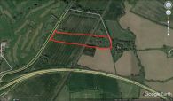
Little Johns, Margaretting (red outline) / Google Earth Street View.
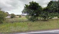
A peek from the A414 across the street into the (former?) Little Johns / Google Earth Street View.

