
Little John Inn (Ravenshead)
From International Robin Hood Bibliography
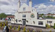
Little John Inn in Ravenshead.
[[File:|thumb|right|500px|Little John Inn in Ravenshead / Google Earth Street View.]]
By Henrik Thiil Nielsen, 2018-05-07. Revised by Henrik Thiil Nielsen, 2020-11-24.
Little John Inn is located on the north side of Main Street in Ravenshead, c. 50 m south of a short residential cul-de-sac named 'Robin Hood Terrace'.
The earliest record known at present is a 25" O.S. map from 1884 (see Maps below). Pub Wiki lists publicans for the years 1925–41.[1] Template:PnItemQry
Gazetteers
- Not included in Dobson, R. B., ed.; Taylor, J., ed. Rymes of Robyn Hood: an Introduction to the English Outlaw (London, 1976), pp. 293-311.
Sources
Maps
- 25" O.S. map Nottinghamshire XXVIII.14 (1884; surveyed 1883)
- 25" O.S. map Nottinghamshire XXVIII.14 (1900; rev. 1898)
- 25" O.S. map Nottinghamshire XXVIII.14 (1900; rev. 1898) (georeferenced)
- 25" O.S. map Nottinghamshire XXVIII.14 (1915; rev. 1913)
- 6" O.S. map Nottinghamshire XXVIII.SW (1885; surveyed 1877-83)
- 6" O.S. map Nottinghamshire XXVIII.SW (1900; rev. 1897-98)
- 6" O.S. map Nottinghamshire XXVIII.SW (1900; rev. 1897-98) (georeferenced)
- 6" O.S. map Nottinghamshire XXVIII.SW (1920; rev. 1913)
- 6" O.S. map Nottinghamshire XXVIII.SW (c. 1949; rev. 1939).
Background
- Nottingham Wayfarers' Rambling Club; Price, Roland, introd. The Robin Hood Walks: A Comprehensive Guide to Walks in Robin Hood Country including the Third Edition of the Guide to the Full Route of Nottinghamshire's First Recreational Footpath, The Robin Hood Way (Leicester: Cordee, ©1994), pp. 113, 117
- Wikipedia: Ravenshead.
Notes
Little John Inn / Google Earth Street View
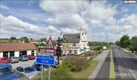
Little John Inn / Google Earth Street View
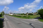
Looking towards the Little John Inn on the B6020, Ravenshead / Tim Heaton, 19 May 2013, Creative Commons, via Geograph.


