
Little John Inn (Ravenshead): Difference between revisions
From International Robin Hood Bibliography
(Created page with "__NOTOC__{{PnItemTop|Lat=53.092724|Lon=-1.156170|AdmDiv=Nottinghamshire|Vicinity=On N side of Main Road in Ravenshead|Type=Public house|Interest=Robin Hood name| Status=Extant...") |
mNo edit summary |
||
| Line 1: | Line 1: | ||
__NOTOC__{{PnItemTop|Lat=53.092724|Lon=-1.156170|AdmDiv=Nottinghamshire|Vicinity=On N side of Main Road in Ravenshead|Type=Public house|Interest=Robin Hood name| | __NOTOC__{{PnItemTop|Lat=53.092724|Lon=-1.156170|AdmDiv=Nottinghamshire|Vicinity=On N side of Main Road in Ravenshead|Type=Public house|Interest=Robin Hood name| | ||
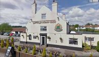
Status=Extant|Demonym=English|Riding=|GreaterLondon=|Year=1884|Aka=|Century=19|Cluster1=Ravenshead|Cluster2=|Cluster3=|Image=little-john-inn-ravenshead-google-earth-street-view.jpg|Postcards=|ExtraCat1=Places named after Little John|ExtraCat2=|ExtraCat3=|ExtraCat4=|ExtraCat5=|ExtraLink1=|ExtraLink2=|ExtraLink3=|ExtraLink4=|ExtraLink5=|ExtraLinkName1=|ExtraLinkName2=|ExtraLinkName3=|ExtraLinkName4=|ExtraLinkName5=|GeopointPrefix=|GeopointSuffix=|VicinitySuffix=|StatusSuffix=|DatePrefix=|DateSuffix=}} | Status=Extant|Demonym=English|Riding=|GreaterLondon=|Year=1884|Aka=|Century=19|Cluster1=Ravenshead|Cluster2=|Cluster3=|Image=little-john-inn-ravenshead-google-earth-street-view-1.jpg|Postcards=|ExtraCat1=Places named after Little John|ExtraCat2=|ExtraCat3=|ExtraCat4=|ExtraCat5=|ExtraLink1=|ExtraLink2=|ExtraLink3=|ExtraLink4=|ExtraLink5=|ExtraLinkName1=|ExtraLinkName2=|ExtraLinkName3=|ExtraLinkName4=|ExtraLinkName5=|GeopointPrefix=|GeopointSuffix=|VicinitySuffix=|StatusSuffix=|DatePrefix=|DateSuffix=}} | ||
{{#display_map:{{#var:Coords}}|width=34%}}<div class="pnMapLegend">Little John Inn in Ravenshead.</div> | {{#display_map:{{#var:Coords}}|width=34%}}<div class="pnMapLegend">Little John Inn in Ravenshead.</div> | ||
[[File:{{#var:Pnimage}}|thumb|right|500px|Little John Inn in Ravenshead / Google Earth Street View.]] | [[File:{{#var:Pnimage}}|thumb|right|500px|Little John Inn in Ravenshead / Google Earth Street View.]] | ||
| Line 33: | Line 33: | ||
</div | </div | ||
{{ImgGalleryIntro}} | {{ImgGalleryIntro}} | ||
<gallery widths="195px"> | <gallery widths="195px"> | ||
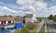
File:little-john-inn-ravenshead-google-earth-street-view-1.jpg|Little John Inn / Google Earth Street View | |||
</gallery | File:little-john-inn-ravenshead-google-earth-street-view-2.jpg|Little John Inn / Google Earth Street View | ||
</gallery> | |||
{{PnItemNav}} | {{PnItemNav}} | ||
Revision as of 01:05, 7 May 2018
Little John Inn in Ravenshead.
[[File:|thumb|right|500px|Little John Inn in Ravenshead / Google Earth Street View.]]
By Henrik Thiil Nielsen, 2018-05-07. Revised by Henrik Thiil Nielsen, 2018-05-07.
Little John Inn is located on the north side of Main Street in Ravenshead, c. 50 m south of a short residential cul-de-sac named 'Robin Hood Terrace'.
The earliest record at present is a 25" O.S. map from 1884 (see Maps below).
Gazetteers
- Not included in Dobson, R. B., ed.; Taylor, J., ed. Rymes of Robyn Hood: an Introduction to the English Outlaw (London, 1976), pp. 293-311.
Maps
- 25" O.S. map Nottinghamshire XXVIII.14 (1884; surveyed 1883)
- 25" O.S. map Nottinghamshire XXVIII.14 (1900; rev. 1898)
- 25" O.S. map Nottinghamshire XXVIII.14 (1900; rev. 1898) (georeferenced)
- 25" O.S. map Nottinghamshire XXVIII.14 (1915; rev. 1913)
- 6" O.S. map Nottinghamshire XXVIII.SW (1885; surveyed 1877-83)
- 6" O.S. map Nottinghamshire XXVIII.SW (1900; rev. 1897-98)
- 6" O.S. map Nottinghamshire XXVIII.SW (1900; rev. 1897-98) (georeferenced)
- 6" O.S. map Nottinghamshire XXVIII.SW (1920; rev. 1913)
- 6" O.S. map Nottinghamshire XXVIII.SW (c. 1949; rev. 1939).
Background
</div
Template:ImgGalleryIntro
Little John Inn / Google Earth Street View
Little John Inn / Google Earth Street View

