
Little John (Markfield)
From International Robin Hood Bibliography
Little John (Markfield).
[[File:|thumb|right|500px|_LEGEND / [_URL _PHOTOGRAPHER_, _DAY_ _MON_. _YEAR_, Creative Commons.]]]
By Henrik Thiil Nielsen, 2018-02-17. Revised by Henrik Thiil Nielsen, 2018-02-18.
Gazetteers
- Not included in Dobson, R. B., ed.; Taylor, J., ed. Rymes of Robyn Hood: an Introduction to the English Outlaw (London, 1976), pp. 293-311.
Maps
- 25" O.S. map Leicestershire XXX.3 (1903; rev. 1901) (georeferenced)
- 6" O.S. map Leicestershire XXX.NE (1904; rev. 1901) (georeferenced)
- 1:25,000 O.S. map Leicestershire XXX.NE (1904; rev. 1901) (georeferenced)
- 1:1 mill.–1:10k, SK501083 (1900s) (georeferenced)
- 1:1m to 1:63, SK501082k (1920s-1940s) (georeferenced)
- 1" O.S. map Atherstone (Hills), Sheet 155, Revised: 1898, Published: 1899 (georeferenced)
- 1" O.S. map Atherstone (Outline), Sheet 155, Revised: 1898, Published: 1899 (georeferenced)
- 1" O.S. map Derby and Leicester (1959; surveyed 1950-56) (georeferenced).
Background
Notes
View of Leicester from the summit of Little John / Mat Fascione, 29 Jul. 2007, Creative Commons, via Geograph.
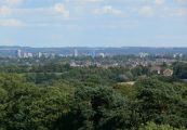
Leicester City Skyline, looking southeast from Little John / Mat Fascione, 29 Jul. 2007, Creative Commons, via Geograph.
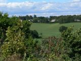
Houses located along the A50, Bradgate Hill, seen from Little John / Mat Fascione, 29 Jul. 2007, Creative Commons, via Geograph.

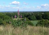
Looking southwest from the summit of Little John / Mat Fascione, 29 Jul. 2007, Creative Commons, via Geograph.


