
Little John (Markfield): Difference between revisions
m (Text replacement - "AdmDiv" to "AdministrativeDivision") |
mNo edit summary |
||
| (7 intermediate revisions by the same user not shown) | |||
| Line 1: | Line 1: | ||
__NOTOC__{{ | __NOTOC__{{PlaceNamesItemTop|Lat=52.6702|Lon=-1.2603|AdministrativeDivision=Leicestershire|Vicinity=1.3 km SSE of Markfield|Type=Natural feature|Interest=Robin Hood name| | ||
Status=Extant|Demonym=English|Riding=|GreaterLondon=|Year=1885|Aka=John's Hill|Century=19|Cluster1=|Cluster2=|Cluster3=|Image=geograph-514030-by-Mat-Fascione.jpg|Postcards=|ExtraCat1=Places named after Little John|ExtraCat2=|ExtraCat3=|ExtraCat4=|ExtraCat5=|ExtraLink1=|ExtraLink2=|ExtraLink3=|ExtraLink4=|ExtraLink5=|ExtraLinkName1=|ExtraLinkName2=|ExtraLinkName3=|ExtraLinkName4=|ExtraLinkName5=|GeopointPrefix=|GeopointSuffix=|VicinitySuffix=|StatusSuffix=|DatePrefix=|DateSuffix=}} | Status=Extant|Demonym=English|Riding=|GreaterLondon=|Year=1885|Aka=John's Hill|Century=19|Cluster1=|Cluster2=|Cluster3=|Image=geograph-514030-by-Mat-Fascione.jpg|Postcards=|ExtraCat1=Places named after Little John|ExtraCat2=|ExtraCat3=|ExtraCat4=|ExtraCat5=|ExtraLink1=|ExtraLink2=|ExtraLink3=|ExtraLink4=|ExtraLink5=|ExtraLinkName1=|ExtraLinkName2=|ExtraLinkName3=|ExtraLinkName4=|ExtraLinkName5=|GeopointPrefix=|GeopointSuffix=|VicinitySuffix=|StatusSuffix=|DatePrefix=|DateSuffix=}} | ||
{{#display_map:{{#var:Coords}}~{{#replace:{{PAGENAME}}|'|'}}|width=34%|enablefullscreen=yes}}<div class="pnMapLegend">Little John.</div> | {{#display_map:{{#var:Coords}}~{{#replace:{{PAGENAME}}|'|'}}|width=34%|enablefullscreen=yes}}<div class="pnMapLegend">Little John.</div> | ||
| Line 6: | Line 6: | ||
A small, sharply defined hill ''c.'' 1.3 km SSE of Markfield and ''c.'' 5 km NW of Leicester, is named Little John. From its summit there is an excellent view in all directions. | A small, sharply defined hill ''c.'' 1.3 km SSE of Markfield and ''c.'' 5 km NW of Leicester, is named Little John. From its summit there is an excellent view in all directions. | ||
The hill appears on the first (1835) 1" O.S. map of the area.<ref>{{:Cox, Barrie 1998a}}, pt. VI, p. 177, and source reference p. xxvii.</ref> The earliest evidence | The hill appears on the first (1835) 1" O.S. map of the area.<ref>{{:Cox, Barrie 1998a}}, pt. VI, p. 177, and source reference p. xxvii.</ref> The earliest evidence IRHS has for the name is a 6" O.S. map of the area from 1885. The English Place-Name Society's volume on this part of Leicestershire notes that | ||
<div class="plainquote" style="padding-bottom:0;">a nod to Little John of the Robin Hood legend is poss[ible]., but otherwise ''John'' is prob[ably]. a familiar name for any notable isolated physical feature, to be compared with the outcropping hill Old John, 3 3/4 miles to the north-east in Bradgate Park.<ref>{{:Cox, Barrie 1998a}}, pt. VI, p. 177. IRHB's brackets. Italics as in source.</ref></div>{{ | <div class="plainquote" style="padding-bottom:0;">a nod to Little John of the Robin Hood legend is poss[ible]., but otherwise ''John'' is prob[ably]. a familiar name for any notable isolated physical feature, to be compared with the outcropping hill Old John, 3 3/4 miles to the north-east in Bradgate Park.<ref>{{:Cox, Barrie 1998a}}, pt. VI, p. 177. IRHB's brackets. Italics as in source.</ref></div>{{PlaceNamesItemAllusionsAndRecords}} | ||
== Gazetteers == | == Gazetteers == | ||
* Not included in {{:Dobson, Richard Barrie 1976a}}, pp. 293-311. | * Not included in {{:Dobson, Richard Barrie 1976a}}, pp. 293-311. | ||
| Line 15: | Line 15: | ||
== Maps == | == Maps == | ||
* 25" O.S. map ''Leicestershire'' XXX.3 (''c.'' 1886; surveyed 1885). No | * 25" O.S. map ''Leicestershire'' XXX.3 (''c.'' 1886; surveyed 1885). No copy in NLS | ||
* [http://maps.nls.uk/view/114593787#zoom=4&lat=7150&lon=4942&layers=BT 25" O.S. map ''Leicestershire'' XXX.3 (1903; rev. 1901)] | * [http://maps.nls.uk/view/114593787#zoom=4&lat=7150&lon=4942&layers=BT 25" O.S. map ''Leicestershire'' XXX.3 (1903; rev. 1901)] | ||
* [http://maps.nls.uk/geo/explore/#zoom=17&lat=52.6708&lon=-1.2600&layers=168&b=1 25" O.S. map ''Leicestershire'' XXX.3 (1903; rev. 1901)] (georeferenced) | * [http://maps.nls.uk/geo/explore/#zoom=17&lat=52.6708&lon=-1.2600&layers=168&b=1 25" O.S. map ''Leicestershire'' XXX.3 (1903; rev. 1901)] (georeferenced) | ||
| Line 34: | Line 34: | ||
== Background == | == Background == | ||
* [https://en.wikipedia.org/wiki/Markfield Wikipedia: Markfield.] | * [https://en.wikipedia.org/wiki/Markfield Wikipedia: Markfield.] | ||
{{ | {{PlaceNamesItemAlsoSee}} | ||
== Notes == | == Notes == | ||
<references/> | <references/> | ||
| Line 40: | Line 40: | ||
<div id="gallery"> | <div id="gallery"> | ||
{{ | {{ImageGalleryIntroduction}} | ||
<gallery widths="195px"> | <gallery widths="195px"> | ||
geograph-514030-by-Mat-Fascione.jpg|Little John / [http://www.geograph.org.uk/photo/514030 Mat Fascione, 29 Jul. 2007, Creative Commons, via Geograph.] | geograph-514030-by-Mat-Fascione.jpg|Little John / [http://www.geograph.org.uk/photo/514030 Mat Fascione, 29 Jul. 2007, Creative Commons, via Geograph.] | ||
| Line 50: | Line 50: | ||
</div> | </div> | ||
{{ | {{PlaceNamesItemNavigation}} | ||
Latest revision as of 22:52, 10 June 2022
| Locality | |
|---|---|
| Coordinate | 52.6702, -1.2603 |
| Adm. div. | Leicestershire |
| Vicinity | 1.3 km SSE of Markfield |
| Type | Natural feature |
| Interest | Robin Hood name |
| Status | Extant |
| First Record | 1885 |
| A.k.a. | John's Hill |

By Henrik Thiil Nielsen, 2018-02-17. Revised by Henrik Thiil Nielsen, 2022-06-10.
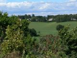
A small, sharply defined hill c. 1.3 km SSE of Markfield and c. 5 km NW of Leicester, is named Little John. From its summit there is an excellent view in all directions.
The hill appears on the first (1835) 1" O.S. map of the area.[1] The earliest evidence IRHS has for the name is a 6" O.S. map of the area from 1885. The English Place-Name Society's volume on this part of Leicestershire notes that
Gazetteers
- Not included in Dobson, R. B., ed.; Taylor, J., ed. Rymes of Robyn Hood: an Introduction to the English Outlaw (London, 1976), pp. 293-311.
Sources
- Cox, Barrie; Watts, Victor, introd.; Coates, Richard, gen. ed.; Cavill, Paul, production ed. The Place-Names of Leicestershire (English Place-Name Society, vols. LXXV, LXXVIII, LXXXI, LXXXIV, LXXXVIII, XC-XCI) (Nottingham, 1998-2016), pt. VI, p. 177, and source reference p. xxvii.
Maps
- 25" O.S. map Leicestershire XXX.3 (c. 1886; surveyed 1885). No copy in NLS
- 25" O.S. map Leicestershire XXX.3 (1903; rev. 1901)
- 25" O.S. map Leicestershire XXX.3 (1903; rev. 1901) (georeferenced)
- 25" O.S. map Leicestershire XXX.3 (1915; rev. 1914)
- 25" O.S. map Leicestershire XXX.3 (1920; rev. 1928)
- 6" O.S. map Leicestershire XXX.NE (1885; surveyed 1885)
- 6" O.S. map Leicestershire XXX.NE (1904; rev. 1901)
- 6" O.S. map Leicestershire XXX.NE (1904; rev. 1901) (georeferenced)
- 6" O.S. map Leicestershire XXX (1919; rev. 1913-14)
- 6" O.S. map Leicestershire XXX.NE (1930; rev. 1928)
- 1:25,000 O.S. map Leicestershire XXX.NE (1904; rev. 1901) (georeferenced)
- 1:1 mill.–1:10k, SK501083 (1900s) (georeferenced)
- 1:1m to 1:63, SK501082k (1920s-1940s) (georeferenced)
- 1" O.S. map Atherstone (Hills), Sheet 155, Revised: 1898, Published: 1899 (georeferenced)
- 1" O.S. map Atherstone (Outline), Sheet 155, Revised: 1898, Published: 1899 (georeferenced)
- 1" O.S. map Derby and Leicester (1959; surveyed 1950-56) (georeferenced).
Background
Also see
Notes
- ↑ Cox, Barrie; Watts, Victor, introd.; Coates, Richard, gen. ed.; Cavill, Paul, production ed. The Place-Names of Leicestershire (English Place-Name Society, vols. LXXV, LXXVIII, LXXXI, LXXXIV, LXXXVIII, XC-XCI) (Nottingham, 1998-2016), pt. VI, p. 177, and source reference p. xxvii.
- ↑ Cox, Barrie; Watts, Victor, introd.; Coates, Richard, gen. ed.; Cavill, Paul, production ed. The Place-Names of Leicestershire (English Place-Name Society, vols. LXXV, LXXVIII, LXXXI, LXXXIV, LXXXVIII, XC-XCI) (Nottingham, 1998-2016), pt. VI, p. 177. IRHB's brackets. Italics as in source.
Image gallery
Click any image to display it in the lightbox, where you can navigate between images by clicking in the right or left side of the current image.
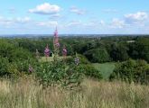
View of Leicester from the summit of Little John / Mat Fascione, 29 Jul. 2007, Creative Commons, via Geograph.
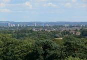
Leicester City Skyline, looking southeast from Little John / Mat Fascione, 29 Jul. 2007, Creative Commons, via Geograph.
Houses located along the A50, Bradgate Hill, seen from Little John / Mat Fascione, 29 Jul. 2007, Creative Commons, via Geograph.

Looking southwest from the summit of Little John / Mat Fascione, 29 Jul. 2007, Creative Commons, via Geograph.


