
Little John (Markfield): Difference between revisions
m (Text replacement - "=== Gazetteers ===" to "== Gazetteers ==") |
m (Text replacement - "=== Sources ===" to "== Sources ==") |
||
| Line 11: | Line 11: | ||
* Not included in {{:Dobson, Richard Barrie 1976a}}, pp. 293-311. | * Not included in {{:Dobson, Richard Barrie 1976a}}, pp. 293-311. | ||
== Sources == | |||
* {{:Cox, Barrie 1998a}}, pt. VI, p. 177, and source reference p. xxvii. | * {{:Cox, Barrie 1998a}}, pt. VI, p. 177, and source reference p. xxvii. | ||
Revision as of 14:42, 12 July 2018
[[File:|thumb|right|500px|Little John, the little hill / Mat Fascione, 29 Jul. 2007, Creative Commons, via Geograph.]]
By Henrik Thiil Nielsen, 2018-02-17. Revised by Henrik Thiil Nielsen, 2018-07-12.
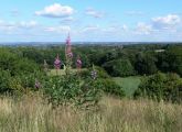
A small, sharply defined hill c. 1.3 km SSE of Markfield and c. 5 km NW of Leicester, is named Little John. From its summit there is an excellent view in all directions.
The hill appears on the first (1835) 1" O.S. map of the area.[1] The earliest evidence i have for the name "Little John" is a 5" O.S. map of the area from 1885. The English Place-Name Society's volume on this part of Leicestershire notes that
Gazetteers
- Not included in Dobson, R. B., ed.; Taylor, J., ed. Rymes of Robyn Hood: an Introduction to the English Outlaw (London, 1976), pp. 293-311.
Sources
- Cox, Barrie; Watts, Victor, introd.; Coates, Richard, gen. ed.; Cavill, Paul, production ed. The Place-Names of Leicestershire (English Place-Name Society, vols. LXXV, LXXVIII, LXXXI, LXXXIV, LXXXVIII, XC-XCI) (Nottingham, 1998-2016), pt. VI, p. 177, and source reference p. xxvii.
Maps
- 25" O.S. map Leicestershire XXX.3 (c. 1886; surveyed 1885). No Copy in NLS
- 25" O.S. map Leicestershire XXX.3 (1903; rev. 1901)
- 25" O.S. map Leicestershire XXX.3 (1903; rev. 1901) (georeferenced)
- 25" O.S. map Leicestershire XXX.3 (1915; rev. 1914)
- 25" O.S. map Leicestershire XXX.3 (1920; rev. 1928)
- 6" O.S. map Leicestershire XXX.NE (1885; surveyed 1885)
- 6" O.S. map Leicestershire XXX.NE (1904; rev. 1901)
- 6" O.S. map Leicestershire XXX.NE (1904; rev. 1901) (georeferenced)
- 6" O.S. map Leicestershire XXX (1919; rev. 1913-14)
- 6" O.S. map Leicestershire XXX.NE (1930; rev. 1928)
- 1:25,000 O.S. map Leicestershire XXX.NE (1904; rev. 1901) (georeferenced)
- 1:1 mill.–1:10k, SK501083 (1900s) (georeferenced)
- 1:1m to 1:63, SK501082k (1920s-1940s) (georeferenced)
- 1" O.S. map Atherstone (Hills), Sheet 155, Revised: 1898, Published: 1899 (georeferenced)
- 1" O.S. map Atherstone (Outline), Sheet 155, Revised: 1898, Published: 1899 (georeferenced)
- 1" O.S. map Derby and Leicester (1959; surveyed 1950-56) (georeferenced).
Background
Notes
- ↑ Cox, Barrie; Watts, Victor, introd.; Coates, Richard, gen. ed.; Cavill, Paul, production ed. The Place-Names of Leicestershire (English Place-Name Society, vols. LXXV, LXXVIII, LXXXI, LXXXIV, LXXXVIII, XC-XCI) (Nottingham, 1998-2016), pt. VI, p. 177, and source reference p. xxvii.
- ↑ Cox, Barrie; Watts, Victor, introd.; Coates, Richard, gen. ed.; Cavill, Paul, production ed. The Place-Names of Leicestershire (English Place-Name Society, vols. LXXV, LXXVIII, LXXXI, LXXXIV, LXXXVIII, XC-XCI) (Nottingham, 1998-2016), pt. VI, p. 177. IRHB's brackets. Italics as in source.
View of Leicester from the summit of Little John / Mat Fascione, 29 Jul. 2007, Creative Commons, via Geograph.
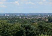
Leicester City Skyline, looking southeast from Little John / Mat Fascione, 29 Jul. 2007, Creative Commons, via Geograph.
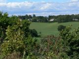
Houses located along the A50, Bradgate Hill, seen from Little John / Mat Fascione, 29 Jul. 2007, Creative Commons, via Geograph.

Looking southwest from the summit of Little John / Mat Fascione, 29 Jul. 2007, Creative Commons, via Geograph.


