
Little John (Markfield): Difference between revisions
mNo edit summary |
mNo edit summary |
||
| Line 4: | Line 4: | ||
[[File:{{#var:Pnimage}}|thumb|right|500px|Little John, the little hill / [http://www.geograph.org.uk/photo/514030 Mat Fascione, 29 Jul. 2007, Creative Commons, via Geograph.]]] | [[File:{{#var:Pnimage}}|thumb|right|500px|Little John, the little hill / [http://www.geograph.org.uk/photo/514030 Mat Fascione, 29 Jul. 2007, Creative Commons, via Geograph.]]] | ||
<p id="byline">By Henrik Thiil Nielsen, 2018-02-17. Revised by {{#realname:{{REVISIONUSER}}}}, {{REVISIONYEAR}}-{{REVISIONMONTH}}-{{REVISIONDAY2}}.</p><div class="no-img"> | <p id="byline">By Henrik Thiil Nielsen, 2018-02-17. Revised by {{#realname:{{REVISIONUSER}}}}, {{REVISIONYEAR}}-{{REVISIONMONTH}}-{{REVISIONDAY2}}.</p><div class="no-img"> | ||
A small, sharply defined hill ''c.'' 1.3 km SSE of Markfield and ''c | A small, sharply defined hill ''c.'' 1.3 km SSE of Markfield and ''c.'' 5 km NW of Leicester, is named Little John. The view from its summit is excellent in all directions. | ||
{{#ask:[[Category:Records ({{#ifeq:{{#pos:{{PAGENAME}}|(|}}||{{PAGENAME}}|{{#sub:{{PAGENAME}}|0| {{#expr:{{#pos:{{PAGENAME}}|(|}}-1}} }},{{#sub:{{PAGENAME}}|{{#expr:{{#pos:{{PAGENAME}}|(|}}-1}}|1}}{{#sub:{{PAGENAME}}|{{#expr:{{#pos:{{PAGENAME}}|(|}}+1}}}}}}]]| format=embedded|embedformat=h4|columns=1|limit=1000|sort=Utitle|intro=<h3>Records</h3>}} | {{#ask:[[Category:Records ({{#ifeq:{{#pos:{{PAGENAME}}|(|}}||{{PAGENAME}}|{{#sub:{{PAGENAME}}|0| {{#expr:{{#pos:{{PAGENAME}}|(|}}-1}} }},{{#sub:{{PAGENAME}}|{{#expr:{{#pos:{{PAGENAME}}|(|}}-1}}|1}}{{#sub:{{PAGENAME}}|{{#expr:{{#pos:{{PAGENAME}}|(|}}+1}}}}}}]]| format=embedded|embedformat=h4|columns=1|limit=1000|sort=Utitle|intro=<h3>Records</h3>}} | ||
| Line 13: | Line 13: | ||
=== Sources === | === Sources === | ||
* {{:Cox, Barrie 1998a}}, pt. VI, p. 177, and source reference p. xxvii. | * {{:Cox, Barrie 1998a}}, pt. VI, p. 177, and source reference p. xxvii. | ||
=== Maps === | === Maps === | ||
* 25" O.S. map ''Leicestershire'' XXX.3 (''c.'' 1886; surveyed 1885). No Copy in NLS | |||
* [http://maps.nls.uk/view/114593787#zoom=4&lat=7150&lon=4942&layers=BT 25" O.S. map ''Leicestershire'' XXX.3 (1903; rev. 1901)] | |||
* [http://maps.nls.uk/geo/explore/#zoom=17&lat=52.6708&lon=-1.2600&layers=168&b=1 25" O.S. map ''Leicestershire'' XXX.3 (1903; rev. 1901)] (georeferenced) | * [http://maps.nls.uk/geo/explore/#zoom=17&lat=52.6708&lon=-1.2600&layers=168&b=1 25" O.S. map ''Leicestershire'' XXX.3 (1903; rev. 1901)] (georeferenced) | ||
* [http://maps.nls.uk/view/114593790#zoom=5&lat=7055&lon=5163&layers=BT 25" O.S. map ''Leicestershire'' XXX.3 (1915; rev. 1914)] | |||
* [http://maps.nls.uk/view/114593793#zoom=5&lat=7025&lon=5076&layers=BT 25" O.S. map ''Leicestershire'' XXX.3 (1920; rev. 1928)] | |||
* [http://maps.nls.uk/view/101592609#zoom=5&lat=5178&lon=2165&layers=BT 6" O.S. map ''Leicestershire'' XXX.NE (1885; surveyed 1885)] | |||
* [http://maps.nls.uk/view/101592606#zoom=5&lat=5133&lon=1966&layers=BT 6" O.S. map ''Leicestershire'' XXX.NE (1904; rev. 1901)] | |||
* [http://maps.nls.uk/geo/explore/#zoom=16&lat=52.6715&lon=-1.2600&layers=6&b=1 6" O.S. map ''Leicestershire'' XXX.NE (1904; rev. 1901)] (georeferenced) | * [http://maps.nls.uk/geo/explore/#zoom=16&lat=52.6715&lon=-1.2600&layers=6&b=1 6" O.S. map ''Leicestershire'' XXX.NE (1904; rev. 1901)] (georeferenced) | ||
* [http://maps.nls.uk/view/102345809#zoom=5&lat=10004&lon=9023&layers=BT 6" O.S. map ''Leicestershire'' XXX (1919; rev. 1913-14)] | |||
* [http://maps.nls.uk/view/101592603#zoom=5&lat=5281&lon=1954&layers=BT 6" O.S. map ''Leicestershire'' XXX.NE (1930; rev. 1928)] | |||
* [http://maps.nls.uk/geo/explore/#zoom=16&lat=52.6709&lon=-1.2592&layers=10&b=1 1:25,000 O.S. map ''Leicestershire'' XXX.NE (1904; rev. 1901)] (georeferenced) | * [http://maps.nls.uk/geo/explore/#zoom=16&lat=52.6709&lon=-1.2592&layers=10&b=1 1:25,000 O.S. map ''Leicestershire'' XXX.NE (1904; rev. 1901)] (georeferenced) | ||
* [http://maps.nls.uk/geo/explore/#zoom=16&lat=52.6709&lon=-1.2592&layers=175&b=1 1:1 mill.–1:10k, SK501083 (1900s)] (georeferenced) | * [http://maps.nls.uk/geo/explore/#zoom=16&lat=52.6709&lon=-1.2592&layers=175&b=1 1:1 mill.–1:10k, SK501083 (1900s)] (georeferenced) | ||
Revision as of 00:53, 18 February 2018
[[File:|thumb|right|500px|Little John, the little hill / Mat Fascione, 29 Jul. 2007, Creative Commons, via Geograph.]]
By Henrik Thiil Nielsen, 2018-02-17. Revised by Henrik Thiil Nielsen, 2018-02-18.
A small, sharply defined hill c. 1.3 km SSE of Markfield and c. 5 km NW of Leicester, is named Little John. The view from its summit is excellent in all directions.
Gazetteers
- Not included in Dobson, R. B., ed.; Taylor, J., ed. Rymes of Robyn Hood: an Introduction to the English Outlaw (London, 1976), pp. 293-311.
Sources
- Cox, Barrie; Watts, Victor, introd.; Coates, Richard, gen. ed.; Cavill, Paul, production ed. The Place-Names of Leicestershire (English Place-Name Society, vols. LXXV, LXXVIII, LXXXI, LXXXIV, LXXXVIII, XC-XCI) (Nottingham, 1998-2016), pt. VI, p. 177, and source reference p. xxvii.
Maps
- 25" O.S. map Leicestershire XXX.3 (c. 1886; surveyed 1885). No Copy in NLS
- 25" O.S. map Leicestershire XXX.3 (1903; rev. 1901)
- 25" O.S. map Leicestershire XXX.3 (1903; rev. 1901) (georeferenced)
- 25" O.S. map Leicestershire XXX.3 (1915; rev. 1914)
- 25" O.S. map Leicestershire XXX.3 (1920; rev. 1928)
- 6" O.S. map Leicestershire XXX.NE (1885; surveyed 1885)
- 6" O.S. map Leicestershire XXX.NE (1904; rev. 1901)
- 6" O.S. map Leicestershire XXX.NE (1904; rev. 1901) (georeferenced)
- 6" O.S. map Leicestershire XXX (1919; rev. 1913-14)
- 6" O.S. map Leicestershire XXX.NE (1930; rev. 1928)
- 1:25,000 O.S. map Leicestershire XXX.NE (1904; rev. 1901) (georeferenced)
- 1:1 mill.–1:10k, SK501083 (1900s) (georeferenced)
- 1:1m to 1:63, SK501082k (1920s-1940s) (georeferenced)
- 1" O.S. map Atherstone (Hills), Sheet 155, Revised: 1898, Published: 1899 (georeferenced)
- 1" O.S. map Atherstone (Outline), Sheet 155, Revised: 1898, Published: 1899 (georeferenced)
- 1" O.S. map Derby and Leicester (1959; surveyed 1950-56) (georeferenced).
Background
Notes
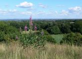
View of Leicester from the summit of Little John / Mat Fascione, 29 Jul. 2007, Creative Commons, via Geograph.
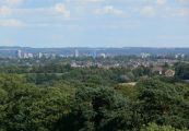
Leicester City Skyline, looking southeast from Little John / Mat Fascione, 29 Jul. 2007, Creative Commons, via Geograph.
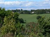
Houses located along the A50, Bradgate Hill, seen from Little John / Mat Fascione, 29 Jul. 2007, Creative Commons, via Geograph.

Looking southwest from the summit of Little John / Mat Fascione, 29 Jul. 2007, Creative Commons, via Geograph.


