
Little John's Mead (Upminster): Difference between revisions
(Created page with "__NOTOC__{{PnItemTop|Lat=51.547806|Lon=0.234751|AdmDiv=Essex|Vicinity=SE side of Little Gaynes Lane in Hacton, Upminster|Type=Area|Interest=Robin Hood name| Status=Defunct|Dem...") |
mNo edit summary |
||
| Line 38: | Line 38: | ||
{{ImgGalleryIntro}} | {{ImgGalleryIntro}} | ||
<gallery widths="195px"> | <gallery widths="195px"> | ||
File:little-johns-mead-google-earth-street-view.jpg|Little John's Mead (red outline) and its larger neighbour, [[Robin Hood (Upminster)|Robin Hood]] (yellow outline) / Google Earth Street View. | File:little-johns-mead-upminster-google-earth-street-view.jpg|Little John's Mead (red outline) and its larger neighbour, [[Robin Hood (Upminster)|Robin Hood]] (yellow outline) / Google Earth Street View. | ||
File:little-johns-mead-google-earth-street-view-2.jpg|These two houses on the SE side of Little Gaynes Lane stand in the NW end of the former Little John's Mead. | File:little-johns-mead-upminster-google-earth-street-view-2.jpg|These two houses on the SE side of Little Gaynes Lane stand in the NW end of the former Little John's Mead. | ||
</gallery> | </gallery> | ||
{{PnItemNav}} | {{PnItemNav}} | ||
Revision as of 20:30, 19 February 2018
[[File:|thumb|right|500px|Little John's Mead (red outline) and its larger neighbour, Robin Hood (yellow outline) / Google Earth Street View.]]
By Henrik Thiil Nielsen, 2018-02-19. Revised by Henrik Thiil Nielsen, 2018-02-19.
The 1842 tithe award for Upminster lists 'Little John's Mead' as the name of a close on the southeast side of Little Gaynes Lane in Hacton, Upminster. Its owner/occupier is listed as the Reverend M. Battiscombe, its state of cultivation as 'Pasture', its area as 1 acre, 3 roods and 26 perches (Template:AcreRoodPerchToM2 m2).[1] The field immediately east of Little John's Mead was named Robin Hood.
Gazetteers
- Not included in Dobson, R. B., ed.; Taylor, J., ed. Rymes of Robyn Hood: an Introduction to the English Outlaw (London, 1976), pp. 293-311.
MS sources
- Tithe award for Barking, online at the Genealogist.co.uk, Piece 12, Sub-Piece 356, Image 013 (requires paid subscription)
- Accompanying map, online at the Genealogist.co.uk, Piece 12, Sub-Piece 356, Sub-Image 001 (requires paid subscription).
Printed sources
Maps
- 25" O.S. map Essex LXXV.5 (1897; rev. 1895)
- 25" O.S. map Essex LXXV.5 (1897; rev. 1895) (georeferenced)
- 6" O.S. map Essex LXXV.NW (1898; rev. 1895)
- 6" O.S. map Essex LXXV.NW (1898; rev. 1895) (georeferenced)
- 6" O.S. map Essex nLXXXVII.NE (1921; rev. 1915)
- 6" O.S. map Essex nLXXXVII.NE (c. 1945; rev. 1938)
- 1:25,000 O.S. map TQ58 (1959; surveyed 1938-55) (georeferenced)
- 1:1 million–1:10k (1900s) (georeferenced).
Background
Notes
- ↑ Tithe award for Barking, online at the Genealogist.co.uk, Piece 12, Sub-Piece 356, Image 013 (requires paid subscription); Genealogist.co.uk, Piece 12, Sub-Piece 356, Sub-Image 001; map (requires paid subscription). Waller, William Chapman, compil. 'Essex Field Names: Part II.—The Hundreds of Beacontree, Chafford, and Barstable, with the Liberty of Havering', Transactions of the Essex Archæological Society, New Series, vol. VI (1898), pp. 60-84; see pp. 62, 73.
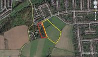
Little John's Mead (red outline) and its larger neighbour, Robin Hood (yellow outline) / Google Earth Street View.
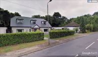
These two houses on the SE side of Little Gaynes Lane stand in the NW end of the former Little John's Mead.

