
Joaney How (Luccombe): Difference between revisions
mNo edit summary |
mNo edit summary |
||
| Line 7: | Line 7: | ||
|data3=[[pnadmdiv::{{#var:County}}]] | |data3=[[pnadmdiv::{{#var:County}}]] | ||
|label4=Vicinity | |label4=Vicinity | ||
|data4=[[pnvicinity::On | |data4=[[pnvicinity::On Luccombe Hill, ''c.'' 2 km SSW of Luccombe]] | ||
|label5=Type | |label5=Type | ||
|data5=[[pntype::Prehistoric site]] | |data5=[[pntype::Prehistoric site]] | ||
| Line 17: | Line 17: | ||
|data8=[[pnfirstrecord::1889]] | |data8=[[pnfirstrecord::1889]] | ||
|label9=A.k.a. | |label9=A.k.a. | ||
|data9= | |data9=Yonney How; Luckham Barrows (together with the neighbouring [[Robin How (Luccombe)|Robin How]]) | ||
}} | }} | ||
{{#display_map:{{#var:Lat}},{{#var:Lon}}|width=34%}}<div class="pnMapLegend">Joanie How.</div> | {{#display_map:{{#var:Lat}},{{#var:Lon}}|width=34%}}<div class="pnMapLegend">Joanie How.</div> | ||
[[File:robin-how-roger-cornfoot-geograph.jpg|thumb|right|500px|The cairn on Robin How / [http://www.geograph.org.uk/photo/2561893 Roger Cornfoot,19 Aug. 2011, Creative Commons.]]] | [[File:robin-how-roger-cornfoot-geograph.jpg|thumb|right|500px|The cairn on Robin How / [http://www.geograph.org.uk/photo/2561893 Roger Cornfoot,19 Aug. 2011, Creative Commons.]]] | ||
<p id="byline">By Henrik Thiil Nielsen, 2017-09-16. Revised by {{#realname:{{REVISIONUSER}}}}, {{REVISIONYEAR}}-{{REVISIONMONTH}}-{{REVISIONDAY2}}.</p><div class="no-img"> | <p id="byline">By Henrik Thiil Nielsen, 2017-09-16. Revised by {{#realname:{{REVISIONUSER}}}}, {{REVISIONYEAR}}-{{REVISIONMONTH}}-{{REVISIONDAY2}}.</p><div class="no-img"> | ||
Joaney How, a large Bronze Age cairn on the edge of a natural terrace on the north slope of Luccombe Hill, survives as an earthwork mound more than 22 metres in diameter and ''c.'' 1.8 m high, with a much mutilated, roughly conical pile of stones whose surface stones are quite loose as if recently moved, suggesting that it may have been rebuilt after destruction.<ref name="pastscape">[http://www.pastscape.org.uk/hob.aspx?hob_id=36963 PastScape: Joanie How.]</ref> | |||
Joanie How is traditionally thought to be named after Little John,<ref name="pastscape"/> while the name of [[Robin How (Luccombe)|Robin How]], its neighbour to the southwest, is believed to refer to Robin Hood. Both of these together with a southern neighbour of the latter used to be referred to collectively as Luckham Barrows. The earliest source to include the names 'Joaney How' and 'Robin How' found so far is the 6" O.S. map from 1889 listed in the Maps section below.<ref name="pastscape"/> | |||
<!--{{#ask:[[Category:Records (_PLACE-NAME)]]| format=embedded|embedformat=h4| columns=1|limit=1000|sort=Utitle}}--> | <!--{{#ask:[[Category:Records (_PLACE-NAME)]]| format=embedded|embedformat=h4| columns=1|limit=1000|sort=Utitle}}--> | ||
<!--{{#ask:[[Category:Allusions (_PLACE-NAME)]]| format=embedded|embedformat=h4| columns=1|limit=1000|sort=Utitle}}--> | <!--{{#ask:[[Category:Allusions (_PLACE-NAME)]]| format=embedded|embedformat=h4| columns=1|limit=1000|sort=Utitle}}--> | ||
=== Gazetteers === | === Gazetteers === | ||
* Not included in {{:Dobson, Richard Barrie 1976a}}, pp. 293-311. | * Not included in {{:Dobson, Richard Barrie 1976a}}, pp. 293-311. | ||
=== Sources === | === Sources === | ||
* [https://historicengland.org.uk/listing/the-list/list-entry/1020930 Historic England: Round cairn cemetery on Dunkery Hill] | * [https://historicengland.org.uk/listing/the-list/list-entry/1020930 Historic England: Round cairn cemetery on Dunkery Hill] | ||
| Line 50: | Line 48: | ||
=== Background === | === Background === | ||
* {{:Gray, H St G 1932a}}, see pp. 124-25. Not seen, but cf. [http://www.pastscape.org.uk/hob.aspx?hob_id=36960&sort=4&search=exact&criteria=robin%20how&rational=q&recordsperpage=10 PastScape]. | * {{:Gray, H St G 1932a}}, see pp. 124-25. Not seen, but cf. [http://www.pastscape.org.uk/hob.aspx?hob_id=36960&sort=4&search=exact&criteria=robin%20how&rational=q&recordsperpage=10 PastScape]. | ||
* {{:Grinsell, L V 1968a}}, see pp. 14, 15, 17, 35 | * {{:Grinsell, L V 1968a}}, see pp. 14, 15, 17, 35. Not seen, but cf. [http://www.pastscape.org.uk/hob.aspx?hob_id=36960&sort=4&search=exact&criteria=robin%20how&rational=q&recordsperpage=10 PastScape]. | ||
* [http://www.megalithic.co.uk/article.php?sid=4959 The Megalithic Portal: Joaney How] | |||
* [http://www.themodernantiquarian.com/site/3517/dunkery_hill_barrows.html Modern Antiquarian: Dunkery Hill Barrows] | * [http://www.themodernantiquarian.com/site/3517/dunkery_hill_barrows.html Modern Antiquarian: Dunkery Hill Barrows] | ||
* [https://en.wikipedia.org/wiki/Dunkery_Hill Wikipedia: Dunkery Hill.] | * [https://en.wikipedia.org/wiki/Dunkery_Hill Wikipedia: Dunkery Hill.] | ||
| Line 83: | Line 82: | ||
[[Category:Places named after Little John]] | [[Category:Places named after Little John]] | ||
{{#set:century={{#var:CenturyOrdinal}}}} | {{#set:century={{#var:CenturyOrdinal}}}} | ||
{{#set:pnaka=Luckham Barrows;Yonney How||+sep=;}} | |||
{{#set:Utitle={{#replace:{{uc:{{PAGENAME}}}}|'|'}}}} | {{#set:Utitle={{#replace:{{uc:{{PAGENAME}}}}|'|'}}}} | ||
<!--{{#set:Pnimage=_IMAGENAME_._EXTENSION_}}--> | <!--{{#set:Pnimage=_IMAGENAME_._EXTENSION_}}--> | ||
Revision as of 06:16, 16 September 2017
| Locality | |
|---|---|
| Coordinates | 51.1739, -3.5632 |
| Adm. div. | Somerset |
| Vicinity | On Luccombe Hill, c. 2 km SSW of Luccombe |
| Type | Prehistoric site |
| Interest | Robin Hood name |
| Status | Extant |
| First Record | 1889 |
| A.k.a. | Yonney How; Luckham Barrows (together with the neighbouring Robin How) |

By Henrik Thiil Nielsen, 2017-09-16. Revised by Henrik Thiil Nielsen, 2017-09-16.
Joaney How, a large Bronze Age cairn on the edge of a natural terrace on the north slope of Luccombe Hill, survives as an earthwork mound more than 22 metres in diameter and c. 1.8 m high, with a much mutilated, roughly conical pile of stones whose surface stones are quite loose as if recently moved, suggesting that it may have been rebuilt after destruction.[1]
Joanie How is traditionally thought to be named after Little John,[1] while the name of Robin How, its neighbour to the southwest, is believed to refer to Robin Hood. Both of these together with a southern neighbour of the latter used to be referred to collectively as Luckham Barrows. The earliest source to include the names 'Joaney How' and 'Robin How' found so far is the 6" O.S. map from 1889 listed in the Maps section below.[1]
Gazetteers
- Not included in Dobson, R. B., ed.; Taylor, J., ed. Rymes of Robyn Hood: an Introduction to the English Outlaw (London, 1976), pp. 293-311.
Sources
- Historic England: Round cairn cemetery on Dunkery Hill
- PastScape: Joanie How
- Exmoor National Park: MSO6251 - Robin How Cairn on Dunkery Hill.
Maps
- 6" O.S. map Somerset XXXIV.SW (1889; surveyed 1888)
- 6" O.S. map Somerset XXXIV.SW (1903; rev. 1902)
- 6" O.S. map Somerset XXXIV.SW (1903; rev. 1902) (georeferenced)
- 6" O.S. map Somerset XXXIV.SW (1930; rev. 1928).
Background
- Gray, H. St. G., 'Rude stone monuments of Exmoor', Somerset Archaeology and Natural History: the Proceedings of the Somersetshire Archaeological and Natural History Society, vol. 78 (1932), pp.121-25, see pp. 124-25. Not seen, but cf. PastScape.
- Grinsell, L.V., 'Somerset Barrows Part 1: West and South', Somerset Archaeology and Natural History: the Proceedings of the Somersetshire Archaeological and Natural History Society, vol. 113 (1968-69) pp. 1-43., see pp. 14, 15, 17, 35. Not seen, but cf. PastScape.
- The Megalithic Portal: Joaney How
- Modern Antiquarian: Dunkery Hill Barrows
- Wikipedia: Dunkery Hill.
Also see
Notes
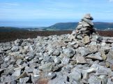
The cairn on Robin How / Roger Cornfoot,19 Aug. 2011, Creative Commons.
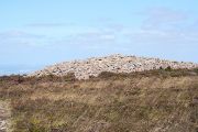
Robin How Cairn. Looking east-north-east from Dunkery Hill / Martin Bodman, 9 Aug. 2006, Creative Commons.
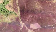
Three grey dots at centre, from top: Joaney How, Robin How, and an unnamed mound / Google Earth Street View. (Click to enlarge).


"th" can not be assigned to a declared number type with value 19.