Ivanhoe Baths (Ashby-de-la-Zouch): Difference between revisions
m (Text replacement - "=== Gazetteers ===" to "== Gazetteers ==") |
m (Text replacement - "=== Sources ===" to "== Sources ==") |
||
| Line 12: | Line 12: | ||
== Gazetteers == | == Gazetteers == | ||
* Not included in {{:Dobson, Richard Barrie 1976a}}, pp. 293-311. | * Not included in {{:Dobson, Richard Barrie 1976a}}, pp. 293-311. | ||
== Sources == | |||
* {{:Cox, Barrie 1998a}}, pt. VII, pp. 8-9, 10, 12; pt. VI, p. xxvii, pt. VII, p. xxvi, for sources | * {{:Cox, Barrie 1998a}}, pt. VII, pp. 8-9, 10, 12; pt. VI, p. xxvii, pt. VII, p. xxvi, for sources | ||
* [http://www.bathgroundsfriends.com/history Friends of Ashby Bath Grounds] | * [http://www.bathgroundsfriends.com/history Friends of Ashby Bath Grounds] | ||
Revision as of 14:32, 12 July 2018

By Henrik Thiil Nielsen, 2017-05-08. Revised by Henrik Thiil Nielsen, 2018-07-12.
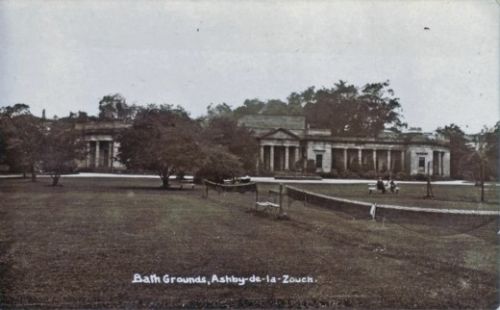
Ivanhoe Baths, housed in a Neoclassical building on Station Road in Ashby-dela-Zouch, opened in 1822. The building was derelict by 1960 and demolished in 1962. In 1805, a saline spring was discovered during coal mining at Moira Colliery, c. 5 km west of Ashby. Baths and a hotel were built, but after a few years it was decided to convey the water to Ashby and establish the business there instead under the name of the Ivanhoe Baths.[1]
The spa was designed by Robert Chaplin and built by the 1st Marquis of Hastings. The building had a 45 m wide collonade in front and a classical dome which let in light for saloon and pump room. There were card rooms, a billiards room as well as private baths for ladies and gentlemen. Remarkably the mineral water for the baths was transported to Ashby by boat and horse-drawn tramway from the spring at Moira colliery. The Bath Grounds included a carriage drive and walks used for recreation.[2]
Barrie Cox discussed Ivanhoe Baths in the English Place-Name Society's seventh volume on Leicestershire, referring to trade directories of 1846, 1863 and 1877 as well as an O.S. map dated 1835.[3]
Gazetteers
- Not included in Dobson, R. B., ed.; Taylor, J., ed. Rymes of Robyn Hood: an Introduction to the English Outlaw (London, 1976), pp. 293-311.
Sources
- Cox, Barrie; Watts, Victor, introd.; Coates, Richard, gen. ed.; Cavill, Paul, production ed. The Place-Names of Leicestershire (English Place-Name Society, vols. LXXV, LXXVIII, LXXXI, LXXXIV, LXXXVIII, XC-XCI) (Nottingham, 1998-2016), pt. VII, pp. 8-9, 10, 12; pt. VI, p. xxvii, pt. VII, p. xxvi, for sources
- Friends of Ashby Bath Grounds
- Wikipedia: Ashby-de-la-Zouch.
Maps
- 6" O.S. map Leicestershire XVI.SW (1886; surveyed 1881-82)
- 6" O.S. map Leicestershire XVI.SW (1904; rev. 1901)
- 6" O.S. map Leicestershire XVI.SW (1904; rev. 1901) (georeferenced)
- 6" O.S. map Leicestershire XVI.SW (1925; rev. 1920).
Postcards
- Close up of Baths Spa (Leicestershire and Rutland Gardens Trust)
- Grounds to Ivanhoe Baths (Leicestershire and Rutland Gardens Trust)
- Ivanheo Baths Spa (Leicestershire and Rutland Gardens Trust; reproduced on this page).
Notes
- ↑ Wikipedia: Ashby-de-la-Zouch.
- ↑ Friends of Ashby Bath Grounds.
- ↑ Cox, Barrie; Watts, Victor, introd.; Coates, Richard, gen. ed.; Cavill, Paul, production ed. The Place-Names of Leicestershire (English Place-Name Society, vols. LXXV, LXXVIII, LXXXI, LXXXIV, LXXXVIII, XC-XCI) (Nottingham, 1998-2016), pt. VII, pp. 8-9, 10, 12; pt. VI, p. xxvii, pt. VII, p. xxvi, for sources.
