
Barnsdale Close (Car Colston): Difference between revisions
mNo edit summary |
mNo edit summary |
||
| Line 6: | Line 6: | ||
A plot of land in Car Colston was known as Barnsdale Close in 1843. | A plot of land in Car Colston was known as Barnsdale Close in 1843. | ||
The close is listed as two contiguous plots in the 1843 tithe award for Car Colston, both with Henry Chettle as owner, Ann Chettle as occupier, 'Pasture' as state of cultivation, and areas of respectively 6 acres, 3 roods and 12 perches ({{AcreRoodPerchToM2|6|3|12}}; m<sup>2</sup>), and just 34 perches ({{AcreRoodPerchToM2|0|0|34}}; m<sup>2</sup>).<ref>1843 tithe award for the parish of Car Colston, online at the [https://www.thegenealogist.com Genealogist.com], piece 26, sub-piece 026, image 191, items #307 and #308 (subscription required); accompanying map, online at the [https://www.thegenealogist.com Genealogist.com], piece 26, sub-piece 026, sub-image 001 (subscription required).</ref> While the field name may have arisen independently, it may also have been transferred from that of [[Barnsdale (Doncaster)]] or [[Barnsdale (Exton)]], or just possible that of [[Barnsdale (Great Easton)]] or [[Eagle Barnsdale]]. Only in case it was named after the area north of Doncaster is there a possible connection with the Robin Hood tradition. The other Barnsdales have no connection with the outlaw. | The close is listed as two contiguous plots in the 1843 tithe award for Car Colston, both with Henry Chettle as owner, Ann Chettle as occupier, 'Pasture' as state of cultivation, and areas of respectively 6 acres, 3 roods and 12 perches ({{AcreRoodPerchToM2|6|3|12}}; m<sup>2</sup>), and just 34 perches ({{AcreRoodPerchToM2|0|0|34}}; m<sup>2</sup>).<ref>1843 tithe award for the parish of Car Colston, online at the [https://www.thegenealogist.com Genealogist.com], piece 26, sub-piece 026, image 191, items #307 and #308 (subscription required); accompanying map, online at the [https://www.thegenealogist.com Genealogist.com], piece 26, sub-piece 026, sub-image 001 (subscription required).</ref> While the field name may have arisen independently, it may also have been transferred from that of [[Barnsdale (Doncaster)]] or [[Barnsdale (Exton)]], or just possible that of [[Barnsdale (Great Easton)]] or [[Eagle Barnsdale]]. Only in case it was named after the area north of Doncaster is there a possible connection with the Robin Hood tradition. The other Barnsdales have no connection with the outlaw. | ||
The location and contours of Barnsdale Close are well indicated on the early O.S. maps. See the map detail in the image gallery below. | |||
{{PnItemQry}} | {{PnItemQry}} | ||
== Gazetteers == | == Gazetteers == | ||
| Line 36: | Line 38: | ||
</div> | </div> | ||
{{ImgGalleryIntro}} | {{ImgGalleryIntro}} | ||
<gallery widths="195px"> | <gallery widths="195px"> | ||
barnsdale-close-car-colston-google-earth-street-view.jpg|Looking SE from Car Lane into the field (formerly?) known as Barnsdale Close / Google Earth Street View. | |||
</gallery | barnsdale-close-car-colston-nls-os-map.jpg|Barnsdale Close is indicated in gray / Detail of [https://maps.nls.uk/view/101603190#zoom=5&lat=3296&lon=6702&layers=BT 25" O.S. map ''Nottinghamshire'' XXXIX.SE (1884; surveyed 1883);] reproduced with the permission of the [https://maps.nls.uk/ National Library of Scotland]; under [https://maps.nls.uk/copyright.html#exceptions Creative Commons Attribution (CC-BY) license;] adaptation by Henrik Thiil Nielsen. | ||
</gallery> | |||
{{PnItemNav}} | {{PnItemNav}} | ||
Revision as of 00:27, 13 September 2020
[[File:|thumb|right|500px|Looking SE from Car Lane into the field (formerly?) known as Barnsdale Close / Google Earth Street View.]]
By Henrik Thiil Nielsen, 2020-09-13. Revised by Henrik Thiil Nielsen, 2020-09-13.
A plot of land in Car Colston was known as Barnsdale Close in 1843.
The close is listed as two contiguous plots in the 1843 tithe award for Car Colston, both with Henry Chettle as owner, Ann Chettle as occupier, 'Pasture' as state of cultivation, and areas of respectively 6 acres, 3 roods and 12 perches (Template:AcreRoodPerchToM2; m2), and just 34 perches (Template:AcreRoodPerchToM2; m2).[1] While the field name may have arisen independently, it may also have been transferred from that of Barnsdale (Doncaster) or Barnsdale (Exton), or just possible that of Barnsdale (Great Easton) or Eagle Barnsdale. Only in case it was named after the area north of Doncaster is there a possible connection with the Robin Hood tradition. The other Barnsdales have no connection with the outlaw.
The location and contours of Barnsdale Close are well indicated on the early O.S. maps. See the map detail in the image gallery below. Template:PnItemQry
Gazetteers
- Not included in Dobson, R. B., ed.; Taylor, J., ed. Rymes of Robyn Hood: an Introduction to the English Outlaw (London, 1976), pp. 293-311.
MS sources
- 1843 tithe award for the parish of Car Colston, online at the Genealogist.com, piece 26, sub-piece 026, image 191, items #307 and #308 (subscription required)
- accompanying map, online at the Genealogist.com, piece 26, sub-piece 026, sub-image 001 (subscription required).
Maps
- 25" O.S. map Nottinghamshire XXXIX.16 (1884; surveyed 1883)
- 25" O.S. map Nottinghamshire XXXIX.16 (1900; rev. 1899) (georeferenced)
- 25" O.S. map Nottinghamshire XXXIX.16 (1900; rev. 1899)
- 25" O.S. map Nottinghamshire XXXIX.16 (1914; rev. 1912)
- 6" O.S. map Nottinghamshire XXXIX.SE (1884; surveyed 1883)
- 6" O.S. map Nottinghamshire XXXIX.SE (1901; rev. 1899) (georeferenced)
- 6" O.S. map Nottinghamshire XXXIX.SE (1901; rev. 1899)
- 6" O.S. map Nottinghamshire XXXIX.SE (1919; rev. 1912–13)
- 6" O.S. map Nottinghamshire XXXIX.SE (1952; rev. 1950).
Background
Notes
- ↑ 1843 tithe award for the parish of Car Colston, online at the Genealogist.com, piece 26, sub-piece 026, image 191, items #307 and #308 (subscription required); accompanying map, online at the Genealogist.com, piece 26, sub-piece 026, sub-image 001 (subscription required).
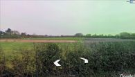
Looking SE from Car Lane into the field (formerly?) known as Barnsdale Close / Google Earth Street View.
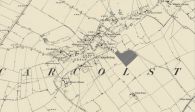
Barnsdale Close is indicated in gray / Detail of 25" O.S. map Nottinghamshire XXXIX.SE (1884; surveyed 1883); reproduced with the permission of the National Library of Scotland; under Creative Commons Attribution (CC-BY) license; adaptation by Henrik Thiil Nielsen.

