
Robin Hood (Stone)
| Locality | |
|---|---|
| Coordinate | 52.902068, -2.143697 ? |
| Adm. div. | Staffordshire |
| Vicinity | 60 Church Street, Stone |
| Type | Public house |
| Interest | Robin Hood name |
| Status | Defunct |
| First Record | 1871 |
| A.k.a. | Robin Hood Inn; Sherwood House |

By Henrik Thiil Nielsen, 2020-11-02. Revised by Henrik Thiil Nielsen, 2021-02-12.
The Robin Hood on 60 Church Street in Stone, Staffordshire, was in existence by 1871 and at least as late as 1911.
The pub is listed as 'Robin Hood Inn', with Joseph Harding as innkeeper, in the 1871 census.[1] In the 1891 census it is 'Robin Hood' tout court, with the same innkeeper.[2]. The 1911 census lists the publican as William Midwinter, giving the street number as 60 and 60 A Church Street.[3] Though heavily renovated, the house presently at 60 Church Street was evidently not constructed recently. Its current name, 'Sherwood House' (see image gallery below), strongly suggests that it once housed the Robin Hood. It is not clear when the pub went out of business, but this could hardly have been later than 1974, when Joules, the local brewery to which it belonged, ceased production and closed its public houses.[4]
Gazetteers
- Not included in Dobson, R. B., ed.; Taylor, J., ed. Rymes of Robyn Hood: an Introduction to the English Outlaw (London, 1976), pp. 293-311.
MS sources
- 1871 Census, County: Staffordshire, Piece 02824, Image 00023, No. of Schedule: 87 (£)
- 1891 Census, County: Staffordshire, Piece 02142, Image 00056, No. of Schedule: 115 (£)
- 1911 Census, County: Staffordshire, Piece 16366, Image: 0329, Ending: 03, No. of schedule: 165 (£).
Web sources
Maps
- 25" O.S. map Staffordshire XXX.2 (1880; surveyed 1878–79)
- 25" O.S. map Staffordshire XXX.2 (1901; rev. 1900) (georeferenced)
- 25" O.S. map Staffordshire XXX.2 (1901; rev. 1900)
- 25" O.S. map Staffordshire XXX.2 (1924; rev. 1922)
- 25" O.S. map Staffordshire XXX.2 (1939; rev. 1937)
- 6" O.S. map Staffordshire XXX.NW (1887; surveyed 1879)
- 6" O.S. map Staffordshire XXX.NW (1901; rev. 1900) (georeferenced)
- 6" O.S. map Staffordshire XXX.NW (1901; rev. 1900)
- 6" O.S. map Staffordshire XXX.NW (1925; rev. 1921–22)
- 6" O.S. map Staffordshire XXX.NW (c. 1949; rev. 1938).
Background
Also see
Notes
- ↑ 1871 Census, County: Staffordshire, Piece 02824, Image 00023, No. of Schedule: 87 (£).
- ↑ 1891 Census, County: Staffordshire, Piece 02142, Image 00056, No. of Schedule: 115 (£)
- ↑ 1911 Census, County: Staffordshire, Piece 16366, Image: 0329, Ending: 03, No. of schedule: 165 (£). The address cited above is from metadata provided by The Genealogist but probably based on the MS source. The 'Postal Address' cited in the latter is 'Robin Hood[,] Stone[,] Staffs'.
- ↑ See Brewerypedia: Joule & Sons - An Essay.
Image gallery
Click any image to display it in the lightbox, where you can navigate between images by clicking in the right or left side of the current image.
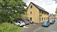
A heavily renovated former Robin Hood? / Google Earth Street View.
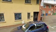
The house has been rechristened 'Sherwood House' / Google Earth Street View.
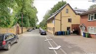
The house looks older from this angle / Google Earth Street View.

